Download
1 / 42
420 likes | 665 Vues
Topic 4 Plate Tectonics—Plate Theory. GEOL 2503 Introduction to Oceanography. Two Parts. Topic 4. The Birth of a Theory Topic 5. Plate Dynamics See videos on Learner.org under the Earth Revealed series See the U. S. Geological Survey on-line publication This Dynamic Earth at

E N D
Topic 4Plate Tectonics—Plate Theory GEOL 2503 Introduction to Oceanography
Two Parts • Topic 4. The Birth of a Theory • Topic 5. Plate Dynamics • See videos on Learner.org under the Earth Revealedseries • See the U. S. Geological Survey on-line publication This Dynamic Earth at http://pubs.usgs.gov/gip/dynamic/dynamic.html
Evolution of plate tectonic thinking • 1620 Francis Bacon: Continents on either side of Atlantic Ocean fit together--continents once were joined? • 1750 Georges Buffon: Life forms similar in Europe and N. America--continents once were joined? • 1883 Edward Suess: Southern hemisphere continents once were joined as super-continent Gondwana • 1908-1912 Alfred Wegener: Proposes hypothesis of “continental drift” • 1950s-1960s: Mapping of ocean floor (and many other discoveries) leads to theory of plate tectonics
In 1858, geographer Antonio Snider-Pellegrini made these two maps showing his version of how the American and African continents may once have fit together, then later separated. Left: The formerly joined continents before their separation. Right: The continents after the separation. From USGS, This Dynamic Earth.
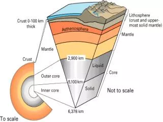
Interior of the Earth • Four main layers Inner core Outer core Mantle Crust • Other layers Lithosphere Asthenosphere
Inner Core • Mostly iron • Magnetized and very hot (4000-5500 C) • Radius of 1222 km. (759 mi.)—about the same size as the moon • Solid due to intense pressure and heat
Outer Core • Mostly iron • 3200 C, slightly cooler than Inner Core • Radius of 2258 km. (1402 mi.) • Has fluid or liquid characteristics
Mantle • Largest layer • 2866 km. (1780 mi.) thick • Cooler than core (1100-3200 C) • Composed of magnesium/iron
Crust • Cold and rigid • Oceanic crust • Thin 10 km (6 mi) • Basalt • Denser • Continental crust • Thick 100 km (60 mi) • Granite • Less dense
Lithosphere • Crust and very upper mantle • Cold and rigid • Brittle—can crack and break • Floats on asthenosphere • Forms the “plates” in plate tectonics
Asthenosphere • Upper part of mantle below lithosphere • Weaker than lithosphere, behaves plastically
Lithosphere (crust and mantle; rigid) Asthenosphere (mantle; plastic) Mesosphere (mantle; rigid)
Evidence for Internal Structure • From seismic waves • P-waves (primary waves) are fast and can penetrate all states of matter • S-waves (secondary waves) are slow and cannot pass through liquid outer core • Patterns of seismic wave travel give information on earth internal structure • Earthquakes and nuclear bomb testing
Don’t worry about the details, just know that this is how we have learned of Earth’s internal structure.
Density • Measure of mass per unit volume (m/v) • Mass versus weight • Units: grams per cubic centimeter (g/cm3) or kilograms per cubic meter (kg/m3) • Average density of Earth 5.51 (g/cm3) • Pure water has a density of 1 g/cm3 which is equal to 1,000 kg/m3
Theory of Continental Drift • Continents move about on the surface of the Earth • Proposed by Alfred Wegener in Early 1900’s • Evidence • Fit of continents • Rock and mountain formations • Fossils • Climatic evidence in fossils and rocks
Glacial striations—formed by gravel and rocks in the ice scratch the rock surface
Large and small rocks, many angular and broken, mixed with very fine silt and clay. Indicative of being dumped from a melted glacier. Diamictite
Diamictite • poorly sorted sediment • glacial origin • deposited by rapidly melting glaciers
The Glossopteris fauna http://geomaps.wr.usgs.gov/parks/pltec/pangea.html
Sea Floor Spreading • Proposed by Harry Hess in 1960 • Proposed convection cells in the mantle as the mechanism for continental drift • Oceanographic observations during the years after World War II provided evidence
Sea floor spreading • Harry Hess (1962) • Mid-ocean ridge site of new ocean crust • Oceanic trench site of crust destruction (subduction) Fig. 2.10
Evidence of Sea Floor Spreading • Earthquakes along spreading and subducting areas • Radiometric dating of rocks (youngest at ridge oldest, farther from ridge) • Magnetism of rocks/polar reversals
Not randomly distributed, but mostly restricted to narrow belts
Ocean crust is young (Y) at spreading centers—and older (O) in both directions away from spreading centers spreading centers O Y O O O Y
Iceland is one place where the spreading center comes up on land.
Paleomagnetism • New oceanic crust is formed as sea floor spreading continues • Earth’s magnetic field reverses often as the ocean crust is formed • Earth’s magnetism is recorded in the new crust • The result is magnetic stripes in the sea floor parallel to ridges recording the magnetic reversals
Magnetic polarity reversals Fig. 2.9
Magnetic anomalies Fig. 2.12