STATIC PPP WITH GPS+GLONASS. A CASE STUDY
This study analyzes the performance of GPS combined with GLONASS for Precise Point Positioning (PPP). Using only an hour of static station data, results indicate that GPS+GLONASS solutions exhibit significantly higher accuracy and reliability compared to GPS-only solutions. Improvements in orbit and clock data, as well as better satellite geometry, further enhance these outcomes, especially in urban environments with limited satellite visibility. The findings highlight the potential of multi-constellation GNSS integration, paving the way for future advancements in positioning accuracy in challenging environments.

STATIC PPP WITH GPS+GLONASS. A CASE STUDY
E N D
Presentation Transcript
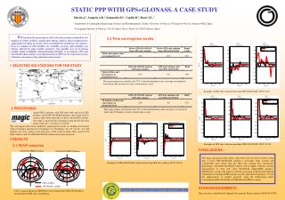
The main conclusion of the study is that when only one hour of static station data is used, GPS+GLONASS solution is noticeably more accurate and considerably more robust than the GPS only solution The convergence percentages with GPS+GLONASS solution will be higher with the constant improvement of orbit and clock GLONASS MagicGNSS products. Furthermore results will improve with the increasing of global and regional distribution of tracking GNSS stations used for generation of products or with the improvement of satellite geometry using the forthcoming multi-constellation GPS+GLONASS+COMPASS+GALILEO scenario GPS satellite GLONASS satellite European Geosciences Union General Assembly 2011 STATIC PPP WITH GPS+GLONASS. A CASE STUDY Martín A.1, Anquela A.B.1, Sanmartin M.1, Capilla R.2, Berné J.L.1 1 Department of Cartographic Engineering, Geodesy and Photogrammetry, Technic University of Valencia, C\Camino de Vera s/n, Valencia 46022, Spain 2 Cartographic Institute of Valencia, C/ de los Santos Justo y Pastor 116, 46022 Valencia, Spain. PPP based on the processing of GPS static observations is limited by the number of visible satellites, among other things, which is often insufficient for applications in urban or narrow areas surrounded by mountains, for instance. Even if a number of GPS satellites are available, accuracy and reliability can still be affected by poor satellite geometry. One possible way of increasing satellite signal availability and positioning reliability is to integrate GPS and GLONASS observations, so an improvement in PPP can be expected in terms of shorter convergence time and increased accuracy 3.2 Time convergence results 1 SELECTED IGS STATIONS FOR THE STUDY These percentages are related to the 70% of the determinations that converge at centimetric level when only one hour of static satation data is used. Example of GPS only solution better than GPS+GLONASS. DOY 33/10. 2 PROCESSING These percentages are related to the 70% of the determinations that converge at 10 cm level when only 30 minutes of static satation data is used. magicGNSS software, with IGS final orbit and clock GPS products and GMV GLONASS products, have been used to analyse daily observation files at the 8 selected IGS stations. Our study is based on the convergence time for the first four hours of the day 1, 33 and 211 of 2010. The convergence have been studied by analyzing the results of stacking observations with a 10 minutes interval (0 to 10 minutes, 0 to 20 minutes, 0 to 30, 0 to 40…0 to 240 minutes) for every station at the three days of the study. It means that a total of 576 GPS solutions and 576 GPS+GLONASS solutions have been analyzed. 3 RESULTS Example of GPS only solution equal than GPS+GLONASS. DOY 211/10. 3.1 PDOP reduction CONCLUSIONS 2010/02/02 BRST Station 2010/30/07 MDVJ Station Example of GPS+GLONASS solution better than GPS only solution. DOY 211/10. ACKNOWLEDGEMENTS A 28 % mean reduction in PDOP have been found when GPS+GLONASS is used instead of GPS only constellation. This research is funded by the Spanish Government. Project number AYA2010-18706