Brian McInerney
140 likes | 285 Vues
Brian McInerney. National Weather Service. Hydrologist. Analysis of the Egypt3 Flash Flood Event. September 10, 2008.

Brian McInerney
E N D
Presentation Transcript
Brian McInerney National Weather Service Hydrologist Analysis of the Egypt3 Flash Flood Event September 10, 2008
On September 10th, 2008 a small but popular slot canyon called Egypt3 experienced a flash flood. Egypt 3 is located in Southern Utah near the Escalante River in the Glen Canyon National Recreation Area. The flood caused two fatalities and injured two others. In total 8 people were in the slot when approximately 0.30 inches of precipitation fell in under an hour. Egypt3 drainage is small, measuring 1.2 mi2. The area is void of vegetation and soil. The underlying parent matter is Navajo Sandstone, and is virtually impermeable. The slot canyon itself is extremely narrow, with recommendations that if you are over 200 lbs, you may not fit through the narrow confines.
Egypt3 Slot Canyon Photos Courtesy of Tom Jones at Tom’s Canyoneering
Egypt 3 Slot Canyon Escalante River Egypt3 Slot Hole in Rock Road
Egypt 3 Slot Canyon Trailhead and Route Road Basin Area 1.2 mi2 Length of slot one way approximately 2.5 miles
The next slide looks at point precipitation frequency estimates. The table on the following slide was established for the headwaters of Egypt 3 slot canyon. The table essentially categorizes rainfall intensities by how big, and often they occur based on rainfall climatology. Very intense thunderstorms may occur only every 50 years or so. For instance, 1.3 inches of rain in one hour statistically occurs once every 50 years at this location. On the other hand, a storm of 0.30 inches in one hour occurs every year. This is the amount of rainfall believed to have fallen in the Egypt3 watershed boundary.This storm is not very significant, and occurs statistically at least once every year according to the frequency tables.
Egypt 3 Slot CanyonOne Hour Frequency Estimate 0.30 inches of rainfall in 1 hour occurs statistically at least once a year over this area.
The next slide looks at radar reflectivity data. This is the data that indicates size and speed of thunderstorms in the area. Typically, the yellow colors indicate rainfall that is somewhat heavy, with sky conditions that are dark, but not necessarily threatening. Red colors, on the other hand indicate black skies and heavy rain. They are categorized by a dbz level of 50.If you notice, about 12:34pm, several cells of dbz level 50 move through the area. This is most likely when the slot canyon received the most intense rainfall event.
The next slide looks at storm total precipitation estimates from the National Weather Service radar that covers this area. The radar depiction in this case indicates the heaviest rainfall fell to the west north west of the Egypt3 slot. As such, it is important to know that there is some error involving exact location of rainfall from a depicted thunderstorm shown on the radar. Such things as storm movement, distance from the radar, curving of the rainfall shaft, and other atmospheric conditions will effect the destination of falling rain.This is probably the case where the heaviest rainfall amount during the storm was adjacent to the slot canyon’s boundaries. Most likely, the amount of rainfall that fell within the Egypt3’s watershed boundary was near 0.20” to 0.40” of rain.
The National Weather Service issues a forecast twice daily to address the potential for flash flooding one to two days out. The forecast looks at atmospheric conditions which may produce a flash flood. The forecast for Wednesday, September 10th, 2008 called for a moderate flash flood potential. A moderate flash flood potential indicates that localized slot canyons, dry washes, and small streams may experience flash flooding
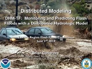
Egypt3 Peak Flow Estimate • Drainage area: 1.2 mi2 • Rainfall Estimate: 0.30”/hr • Land Surface: • Impervious Navajo Sandstone • Absence of Vegetation • Steep slot canyon • Time of Concentration or water to flow from top of slot canyon to outlet was calculated to be approximately 30 minutes • Time to Peak, which is the time from the beginning of rainfall to the time of peak discharge was estimated to be 24 minutes • Peak Discharge was estimated to be approximately 450 cfs. • With channel dimensions as they are, it is probable that depth of flood exceeded 20 ft. • Actual calculations and analysis methods are available
Contact Information Brian McInerney801.971.2033 cbrian.mcinerney@noaa.gov