Download
1 / 24
240 likes | 399 Vues
Location Aware Information System (LAIS). Neftali Alverio Bryan Halter Jeff Cardillo Brian Reed Advisor: Prof. Tilman Wolf. LAIS Project Overview. Provide location specific information on wireless PDA Maps, businesses, events, etc. Updates as you travel Example:

E N D
Location Aware Information System(LAIS) Neftali Alverio Bryan Halter Jeff Cardillo Brian Reed Advisor: Prof. Tilman Wolf
LAIS Project Overview • Provide location specific information on wireless PDA • Maps, businesses, events, etc. • Updates as you travel • Example: • Campus tour with wireless client • Required: • Pocket PC • GPS device • Internet access (wireless Ethernet or cellular)
Database Challenges • Store location relevant information • Ranges instead of points • Large amount of information • Efficiently query any point in the world • Map the spherical Earth into database tables
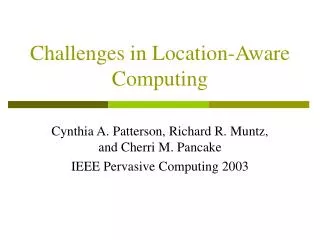
World Subdivision Quadrant 1 Quadrant 2 Quadrant 3 Our Cell: 1… Our Cell: 14… Quadrant 4
Local cells Cell Algorithm • Used by Scavenger & Server • Matching Latitudes & Longitudes to cells • Divides current cell into 4 equal pieces • Select sub-cell by comparing Latitude & Longitude • Repeated 16 times • UMass Engineering Quad – 1411223332432413 • Width of cells thins out towards the poles • Find set of cells for a user given range
Database Design • 16 layers for data of different sizes • Finest resolution is 1/3 mile x 1/3 mile • To store and retrieve information • Cell number is key to data • Need to calculate cell number from geographic coordinates • Separation of locations and their information • One to many relationship
LAIS Location FinderChallenges • Admin specifies location and type of information • Example: • Banks in Amherst, MA 01003 • Challenge: • Getting GPS coordinates for address • Commercial solutions: • Microsoft MapPoint.NET ($5,000 for student license) • Web sources: • superpages.com and gps.algebra.com
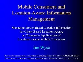
category links Location Finder ProcessFinding Locations using superpages.com http://yp107.superpages.com/listings.phtml?SRC=&STYPE=D&PG=L&RLO=&RLT=&CB=&C=&N=&RR=5&AL=&RE=&RT=[City]&RS=[State]&RZ=[ZipCode]&R=D&search=Find+It URL used will have actual city state and zip filled in where red text apears Sample of a resulting webpage with links to categories
Sample webpage of location results for a category type. Location Finder ProcessFinding Locations using superpages.com • Search for listings on superpages.com based on admin preferences • Use form post method per area for listings • Parse source code to extract listings.
Location Finder ProcessAcquiring Cell Number and GPS Coordinates • Break address into 2 parts after first comma from previous process. • 253 Triangle St, Amherst, MA 01002 becomes • 253 Triangle St • Amherst, MA 01002 • Feed into gps.algebra site via form post • Parse results for Latitude and Longitude. http://gps.algebra.com/?addr1=253 Triangle St&addr2=Amherst, MA 01002
Purpose Obtain information about locations from web Update automatically Require minimal human intervention Challenges Web pages lack well defined form All relevant data is not in one section HTML page not well suited to output Information Retrieval
Parsing Steps Remove all but useful sections Remove HTML Tags Remove tabs and carriage returns Remove extra spaces Store to the database
Raw HTML <br> </td> </tr> <tr> <td width="50%" bgcolor="#ffffff"> <font face="Arial"><font color="#800000"> <a href="http://www.ecs.umass.edu/ece/ lectures/martinez.html"> Jose Martinez </a> </font></font> <br> <i><font color="#800000"> University of Illinois/Urbana-Champaign, Computer Science </font></i> <br><i> <font color="#800000"> Title: Speculative Shared-Memory Architectures</font></i> <br> <font color="#800000"> February 25, 4:00 p.m., 132 Marston</font> <br> <fontcolor="#800000"> </font> </td> <td><br> Syntax Recognition Desired Output Jose Martinez University of Illinois/Urbana-Champaign, Computer Science Title: Speculative Shared-Memory Architectures February 25, 4:00 p.m., 132 Marston Syntax Rule Token: <br> Sections before: 3 Sections after: 0
Data storage • Data is stored with a type, entry date, reference URL, referred to location • Data is stored in a table corresponding to the layer on which the location it refers to exists.
Client/Server Interactions • Client: • Get GPS coordinates • Send request to server via wireless link • Server: • Receive request • Query database • Generate output map • Client: • Display page
System Demo User Login User Preferences
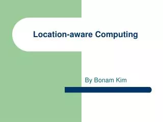
University of Massachusetts Campus Our location is the W.E.B Dubois library (marked red). Maps with a zoom of 1.5 mi (left), 1 mi (center), and .5 mi (right)
University of Massachusetts Campus Same location as before but with a road map shown.
Budget • Hardware: • PDA ($500) • Server ($2,000) Donated by Microsoft • GPS Unit ($300) • Wireless Access Points ($150) • Software • Visual Studio .NET • Microsoft SQL Server • Submitted grant to Microsoft • Microsoft funds everything excluding the GPS