Download

1 / 6
60 likes | 135 Vues
Explore the detailed photorealistic survey findings of rock formations in Pine Canyon and Cedar Canyon in Rock Springs, focusing on key outcrops and geological features. The study provides a comprehensive view of the fluvial-deltaic-estuarine rocks of the upper Mesaverde Group.

E N D
Ole J. Martinsen Photorealistic Surveying Rock Springs 2004
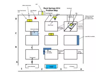
Aims Pine Canyon • Survey Ericson Sandstone and lower part of Almond Formation in northernmost Rock Springs Uplift • Primary location: Pine Canyon • Secondary location: Cedar Canyon • 2 miles south of Pine Canyon and closest to UW#1 well • Cliff wall lies immediately south of well location • Attempt to cover entire Pine Canyon with 3-D perspective of fluvial-deltaic-estuarine rocks of upper Mesaverde Group • Particular focus on northern and western sides of canyon where outcrops are best Cedar Canyon
Stratigraphy and location, Pine Canyon Priority 1: Concentrate on the outcrops along line with focus on area around logs UW #1 well Priority 2: Great cliffwall on north side of Cedar Canyon just south of well location (see UTM coordinates in box). Well location is at 2237 m above sea level.
Cedar Canyon cliff wall, immediately south of UW#1 (on top of hill in background) UW #1 well