Download
1 / 4
40 likes | 59 Vues
The SeaWiFS Project supports the Volvo Ocean Adventure, providing content and near real-time maps of ocean color for yachts sailing in different regions. The project also analyzes and compares satellite data to study Antarctic sea ice concentrations and changes. High frequency microwave observations are used to detect snowfall over land.

E N D
SeaWiFS Highlights September 2001 SeaWiFS Races Around the World The SeaWiFS Project is helping support the Volvo Ocean Adventure, which is the educational component of the Volvo Ocean Race by providing content, images, and near real-time maps of ocean color for the regions of the world's ocean in which the yachts are sailing. Having left Southampton, England on Sunday, 23 September, the yachts are now approaching the Canary Islands as can be seen above and in the latest SeaWiFS image. For nine long months, eight yachts will sail through some of the most demanding ocean conditions as they circle the globe with SeaWiFS keeping an eye on them every day. For more information about SeaWiFS’ role in this venture, please go to the following URL: http://www.volvooceanadventure.org/article.php/rz_4_tci.html
SeaWiFS Races Around the World September 30, 2001
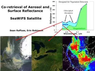
Antarctic Sea Ice Concentrations Satellite Landsat, OLS, and AVHRR data have been analyzed and compared with ice concentrations derived from passive microwave (PM) data. The results show generally good agreement in consolidated sea ice regions, especially in winter. The PM data, however, show changes in ice concentration that reflects the changes associated with changing seasons and ice type. The physical changes are vividly illustrated in the Landsat images (right) over the same area during autumn and spring. The ability to detect such changes in surface properties and ice types is important since it enables identification of polynya and divergence activities and a good quantification of fluxes between the ocean and the atmosphere. The study also shows that good consistency in the derived ice concentrations are needed, especially when different PM sensors are used, for accurate trend and variability studies of the sea ice cover. Reference: Comiso, J. and K. Steffen, Studies of Antarctic Sea Ice Concentration and their Application, J. Geophys. Res. C (in press). (a) autumn (b) Spring
High Frequency Microwave Observations of SnowfallG. Skofronick-Jackson, J. A. Weinman, D.-E. ChangCode 975 85GHz PCT 3/6/01 0102UTC 183±7 GHz 3/5/01 2302UTC GPM would be greatly enhanced if it were able to detect snow and light rain over land. Snow during the March 2001 New England blizzard could not be observed from SSM/I 85 GHz brightness temperatures because 85 GHz is sensitive to snow in the air and on the ground (A). The AMSU-B 183 + 7 water vapor sounding channel appears to be insensitive to snow on the ground yet is sensitive to snow in the air (B). The 183 GHz feature moves off-shore as would be expected from an atmospheric feature (C) and it is in the right place according to the NWS radar (D). A B 183±7 GHz 3/6/01 1302UTC NEXRAD 3/5/01 2300UTC D C