Resolution
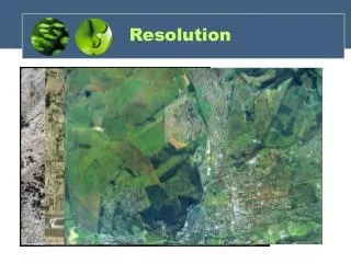
Resolution. Landsat ETM+ image. What are the four types of resolution?. Spatial Spectral Radiometric Temporal. Spatial Resolution. Usually reported as th e length of one side of a single pixel


Resolution
E N D
Presentation Transcript
What are the four types of resolution? • Spatial • Spectral • Radiometric • Temporal
Spatial Resolution • Usually reported as the length of one sideof a single pixel • In analog imagery, the dimension (e.g. width) of the smallest object on the ground that can be distinguished in the imagery • Determined by sensor characteristics (for digital imagery), film characteristics (for air photos)field of view, altitude, and.
Group Problem If you have a study area that covers 1 km2, how many Landsat 30 m pixels does it take to cover it (nearest whole number)? How many 15 m panchromatic pixels would it take to cover the same area?
IFOV 1 pixel
Raster pixel size Higher resolution Lower resolution
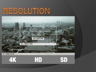
Available Spatial Resolution for Land RS • Satellites: ~ 0.5 m to1 km • Air photos ~ centimeters to meters
Satellite data resolution • MODIS: 250 - 1000 m • Landsat MSS: 80 m • Landsat 5, 7, 8: 30 m (15 m panchromatic) • IRS MS: 22.5 m (5 m pan) • SPOT: 20 m • ASTER: 15m • Digital Globe: 2 m (0.5 m pan)
Quickbird (Digital Globe, Inc.) ~ 2.4 m spatial resolution in multispectral bands.
MODIS 500 m spatial resolution
Spatial Resolution Trade-offs • Data volume • Signal to Noise Ratio • “Salt and Pepper” • Cost
Spectral Resolution Can be described two ways, but they usually go hand in hand. • How many spectral “bands” an instrument records • How “wide” each band is (the range of wavelengths covered by a single band)
Spectral resolution • Related to the measured range of EMR • Wide range - coarse resolution • Narrow range - finer resolution
Case 1 • Measure the EMR across a wide range • E.g., a single panchromatic band covering the entire visible portion of the spectrum • Assigns a single DN representing all visible light energy hitting the sensor • Analogous to black and white (panchromatic) film
green blue red UV Near-infrared 0.4 0.5 0.6 0.7 Case 1
Case 2 Measure EMR across narrower ranges E.g., Separate bands for blue, green and red parts of the spectrum Assign a DN for each of these wavelength ranges to create 3 bands
green blue red UV Near-infrared 0.4 0.5 0.6 0.7 Case 2
Red Green Blue Coarser (lower) Spectral Resolution RGB Finer (higher) Spectral Resolution
High Spectral Resolution Spectral reflectance curve for green leaf using 224 bands (high spectral resolution) Reflectance Wavelength (nm) Low Spectral Resolution Spectral reflectance curve for green leaf using 6 bands (lower spectral resolution) Reflectance Wavelength (nm)
Could you distinguish Dolomite from Calcite using Landsat 8 spectral data?
Spectral Resolution Trade-Offs • Data Volume and processing 1 DN for each pixel in EACH BAND • Signal to Noise Ratio • Cost
Group Problem For your 1 km2 study area, if you use 7 Landsat 8 bands, how many DNs will your computer have to store?
Radiometric Resolution • How finely does the satellite divide up the radiance it receives in each band? How much light does it take to change the DN from one number to the next? • Usually expressed as number of bits used to store the maximum possible DN value • 8 bits = 28 = 256 levels (usually 0 to 255) • 16 bits = 216 = 65,536 levels (0 to 65,535)
26 = 64 levels (6 bit) 22 = 4 levels (2 bit)
Radiometric resolution • 1 bit ( 0 - 1) • 8 bit ( 0 - 255 ) (older Landsats, many others) • 16 bit ( 0 - 65,535 ) (Landsat 8) • 32 bit ( 0 - 4,294,967,295 ) (uncommon) For an 8-bit satellite: DN = 0: No EMR or below some minimum amount of light (threshold) DN = 255: Max EMR or above some maximum amount of light
Radiometric resolution • 8 bit data (256 values) • Everything will be scaled from 0 – 255 • Subtle details may not be represented • 16 bit data (65,536 values) • Wide range of choices • Required storage space will be twice that of 8 bit
Radiometric Radiation Trade Offs • Data volume Every 8 bits takes 1 byte to store on a computer. One 8-bit DN takes 1 byte One 16-bit DN takes 2 bytes Etc.
Group Problem If your are using 7-band, 16-bit Landsat 8 data for your 1 km2 area, how many bytes are needed to store your DNs on your computer?
Calculating Image Size Computer hard drives store data in “boxes” called bytes (e.g., 1 Mb = 1 million bytes) 1 byte can hold 8 binary (base 2) digits (0s or 1s or some combination of 0s and 1s) Each “bit” is a single binary digit An 8-bit number is made of of 8 binary digits and fits into 1 byte. A 9-bit number won’t fit in 1 byte and requires 2 bytes.
Temporal resolution • Time between two subsequent data acquisitions for an area All of the Landsat satellites have a 16-day return time MODIS has a 1-2 day return time.
Return Time (Temporal Resolution) • Depends on: • Orbital characteristics • Swath width • Ability to point the sensor
Orbital Characteristics • Geosynchronous • Polar • Sun synchronous
Geosynchronous Orbits • Satellite orbits the earth at a rate that allows it to match the earth’s rotation—so the satellite is always over the same place • Narrow range of altitudes—about 35,786 km above the equator. • Useful for communications, weather etc. • Example: GOES satellite (weather) • Geosynchronous orbiting earth satellite
Polar/Sun Synchronous Orbits • Pass roughly over the north and south poles • Fly over the same place on earth at the same time of day • Examples: Landsat, AVHRR • Good for land remote sensing • Return time related to spatial resolution, latitude, swath width, and orbital altitude
Return Time Trade Offs • Spatial resolution • Viewing geometry effects (off nadir) • Clouds and other atmospheric problems • Lack of archival repeat coverage for pointable satellites
In summary, choosing a satellite is often an exercise in weighing the relative trade-offs of resolution against data needs.