Water on Mars
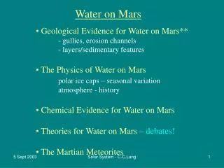
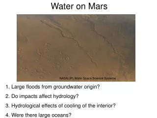
NASA/JPL/Malin Space Science Systems. Water on Mars. Michael Manga, UC Berkeley. Large floods from groundwater origin? Do impacts affect hydrology? Hydrological effects of cooling of the interior? Were there large oceans?. Why study water on Mars?.

Water on Mars
E N D
Presentation Transcript
NASA/JPL/Malin Space Science Systems Water on Mars Michael Manga, UC Berkeley Large floods from groundwater origin? Do impacts affect hydrology? Hydrological effects of cooling of the interior? Were there large oceans?
Why study water on Mars? • Climate and habitability (Mars and Earth were not so different once...) • Human exploration • Water and life • Testing terrestrial science
Water on present-day Mars 1. Atmosphere • But not much! (precipitable mm) 2. Polar Caps 3. Mantle 4. Regolith
Water on present-day Mars 1. Atmosphere 2.Polar Caps • N cap equivalent to 9m global ocean • S cap has CO2 frost cover (water beneath) 3. Mantle 4. Regolith NASA/JPL/MSSS
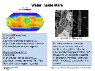
Water on present-day Mars 1. Atmosphere 2. Polar Caps 3. Mantle (?) • Meteorites contain hydrous minerals, but these may have formed at the surface 4. Regolith
Water on present-day Mars 1. Atmosphere 2. Polar Caps 3. Mantle 4. Regolith • Mars Odyssey mission: abundant ground ice at high southern latitudes NASA/JPL/U. Arizona
Water on early Mars “Valley networks” • Dendritic networks suggest erosion by surface runoff • On Noachian-age crust 50 km Viking image of Warrego Valles
Water on early Mars “Valley networks” • Evidence for sustained flow: Fans, meander bends, scroll bars Moore et al., GRL 2003; Malin & Edgett, Science 2003 • NASA/JPL/MSSS
NASA/JPL/Cornell Mars Exploration Rovers (MER) • Outcrop-scale evidence of water-rich environment in Meridiani Planum (Opportunity)
Water on early Mars “Outflow channels” • Large channels originate at point source • Q ~100 to 10000 x Mississippi R. (> 106 m3 s-1) • Spatial association with collapsed terrain suggests subsurface fluid source • Total Vol ~ 107 km3 (where did it go?) 150 km 50 km
Global hydrogeology,aquifers on Mars? • North-south gradient in elevation • Lots of craters
Clifford and Parker (2001) Global hydrogeology,aquifers on Mars? • North-south gradient in elevation • Lots of craters
NASA/JPL/Malin Space Science Systems Water on Mars Michael Manga, UC Berkeley Large floods from groundwater origin? Do impacts affect hydrology? Hydrological effects of cooling of the interior? Were there large oceans?
1. Recent (<10 Ma) floods at Cerberus Fossae Did these floods have a groundwater origin?
Murray et al., Science (2005) 1. Recent (<10 Ma) floods at Cerberus Fossae Did these floods have a groundwater origin?
Can subsurface aquifers deliver enough water, and deliver it fast enough to make the features we see?
Can subsurface aquifers deliver enough water, and deliver it fast enough to make the features we see? YES A groundwater source in a large deep aquifer is plausible if k is large enough Is k ~ 10-9 m2 reasonable?
Quinn River Cultus River Permeability of basalt aquifers: The High Cascades
Useful features • Nearly constant discharge • Peak discharges lags recharge by 1-6 months
Flow governed by Response characterized by diffusion time
Conclusion: A groundwater source in a large deep aquifer is plausible if k is large enough Is k ~ 10-9 m2 reasonable? Yes, if aquifers are made of basaltic lava flows, not too much weathering
Compared with Earth, slow hydrological cycling • Geological processes that are • infrequent • slow • may be hydrological important • Two examples • Impacts • Secular cooling of the planet
2. Impacts and groundwater • Shaking from earthquakes • changes pore pressure • increases streamflow • causes liquefaction
Shaking from earthquakes • changes pore pressure • increases streamflow • causes liquefaction
Shaking from earthquakes • changes pore pressure • increases streamflow • causes liquefaction Connection to earthquakes? Impacts also shake the ground
Distance over which liquefaction occurs, streamflow increases Wang, Manga, Wong, Icarus (2005) Empirical upper bound
Scaling of impact shaking to earthquakes Size-energy scaling (Melosh, 1978) Seismic efficiency Maximum distance for liquefaction
Origin of “chaotic terrain”? lateral spreading?
3. Slow processes may be important on Mars: As planet cools, cryosphere gets thicker Implications for groundwater?
Cooling Cryosphere thickens Water erupts when pressure becomes lithostatic Water pressure increases Discharge continues until pressure is hydrostatic A small number (of large) floods may be possible,
Carr & Head, JGR 2003 4. Paleoshorelines on Mars?
Webb, JGR 2004 Paleoshorelines on Mars? ~300 km Bonneville paleoshoreline, Utah www.geo.cornell.edu
Interpolation artifacts [Carr & Head, 2003; Webb, 2004] Problem: Shorelines don’t follow an equipotential surface [Head et al., 1999; Carr & Head, 2003] Raw elevations from Carr & Head [2003]
Long-wavelength lithospheric deformation • Loading by H2O (Leverington and Ghent) • Flexural response to large surface loads • Dynamic topography (mantle convection) • True polar wander (TPW)
TPW + elastic lithosphere spatially non-uniform change in topography Initial Final Difference a Difference in centrifugal potential determines geometry of sea level response [Mound & Mitrovica 1998]
TPW + elastic lithosphere spatially non-uniform change in topography a Amplitude depends on amount of TPW, elastic thickness of lithosphere, and internal density structure Degree 2 fluid tidal Love numbers Topography decreases Topography increases Details of TPW calculations in Matusyama et al. (2006)
Inversion procedure • Monte Carlo search for best-fit paleopoles for 100 km ≤Te≤ 400 km • Allow constant C to vary freely • Minimize RMS misfit between S(q,y) and shoreline topography
Displacement (km) Approach: use shoreline topography to infer paleopole locations Present pole Paleopole Shoreline Elevation increases Elevation decreases
Best-fit paleopoles Deuteronilus (younger, shallower) Te= 200 km Arabia (older, deeper)
Best-fit paleopoles Inferred TPW path implies Tharsis would remain at the equator 90° What caused the polar wander?
TPW Implications Equatorial ocean ~4Ga? Ocean volumes Arabia, 690 m Deuteronilus, 150 m
Oceans on Mars: Open questions • Source of water, ocean formation time? • Short- and long-term fates of ocean water? • Independent evidence of oceans?
Oceans are a major uncertainty in Mars’ global water budget Arabia Northern ocean plains Deuteronilus North Polar caps South Regolith Lost to space 0.2 0 0.05 0.1 0.15 Volume in billions of km3) Based on data from Clifford and Parker (2001), Zuber et al. (1998), Smith et al. (1999) and Kass (2001) Clifford & Parker [2001], Zuber et al. [1998], Smith et al. [1999], Kass [2001]; as summarized by Carr & Head [2003]
Collaborators Chi-Yuen Wang Martin Saar Alex Wong Isamu Matsuyama Jerry Mitrovica Taylor Perron