Weather and Climate
Weather and Climate. Unit 1B. Key Question 1. Elements and measurements of the weather. WEATHER is about day to day changes in the atmosphere. It includes changes in temperature, rainfall, sunshine & wind). CLIMATE

Weather and Climate
E N D
Presentation Transcript
Weather and Climate Unit 1B
Key Question 1 Elements and measurements of the weather
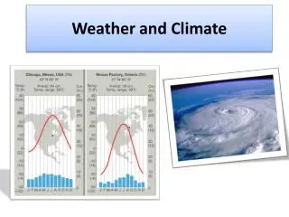
WEATHER is about day to day changes in the atmosphere. It includes changes in temperature, rainfall, sunshine & wind) CLIMATE is the average or typical weather of a place worked out over a long period of time. What is the difference between weather and climate ? We know that in Britain it gets cold in the winter and warm in the summer. This is climate. But we don't know if it is going to be warm tomorrow or not. This is the weather.
Weather Elements 1. Temperature 2. Precipitation 3. Wind Speed 4. Wind Direction 5. Cloud Cover 6. Cloud Type 7. Visibility 8. Air Pressure
Cloud Cover Chart RIGHT Types of Cloud
What type of cloud is this ? Found at high altitudes - CIRRUS
What type of cloud is this ? They rise to very great heights and are associated with thunderstorms - CUMULONIMBUS
The Stevenson Screen Characteristics • It is white • It has slatted sides • It has a double roof • It is on stilts • Its door opens northwards
Key Question 2 The Influence of AIR MASSES over the British Isles
Air Masses Blackwood Comprehensive School.
What is an air mass? • An air mass is a large body of air with similar temperature and/or humidity. • Air masses form in stable “source regions” such as in the sub tropics or near to the poles.
Air Mass types Five main air masses affect Europe
Tropical Maritime (Tm) - mild and moist Tropical Continental (Tc) - warm and dry Polar Maritime (Pm) - cool and moist Polar Continental (Pc) - cold and dry Arctic Maritime (Am) - cold and moist Air mass classification
Tropical Maritime Tm air masses come from the south west and originate over the Azores or the Caribbean. They bring mild, damp, cloudy weather.
Tropical Continental Tc air masses come from the south and originate over dry northern Africa . They bring hot, dry weather and summer heatwaves.
Polar Maritime Pm air masses come from the north-west and originate over the north Atlantic. They bring cool, moist conditions.
Polar Continental Pc air masses come from the east and originate over Scandinavia and Russia . They bring clear dry conditions - cold in winter, warm in summer.
Key Question 3 Depressions and Anticyclones
Air stops rising when it meets air of equal density, then diverges at high level to produce more wind which eventually sinks elsewhere to complete the circulation cell Pressure, Wind and Weather Systems • WINDS are horizontal flows of air; winds blow from areas of high pressure to areas of low pressure (nature tries to equalise pressure) • PRESSURE describes the tendency of the air to rise or to sink at any given place or time. • Air tends to rise or sink as a result of its density. • Air density varies with altitude but, at the ground level, air density is governed by its temperature. • Thus, variations in radiation and temperature control pressure and wind. Insolation Air heated by contact with ground expands; becomes less dense and rises Denser air drawn in at low level to replace rising, less dense air LOW PRESSURE Denser air drawn in at low level to replace rising, less dense air Sun heats up ground
Wind strength depends on the difference in pressure between the high and low pressure systems, and the distance between them. • This is called the PRESSURE GRADIENT; it is a similar concept to the physical slope between two places, shown on a contour map. Pressure is shown by ISOBARS on a weather map. • Pressure difference essentially depends on the temperature difference between the two places. Farmers plant trees to protect orchards, houses, stock or prevent soil erosion Strong polar winds due to low friction Beach windbreaks reduce windsped by increasing friction Hurricane in Florida Tornado in USA WIND DIRECTION & STRENGTH Locally, wind is channelled down streets (wind canyons). Strong winds also occur in low latitudes due to stronger heating and steeper presure gradients. Hurricanes and tornadoes are both tropical phenomena. A steep pressure gradient results from a large pressure difference or short distance between places and causes strong wind.
LITTLE WIND VISIBLITY REMAINS BETTER IN MOUNTAINS - LESS POLLUTION CLEAR SKIES FEW CLOUDS CLEAR SKIES CAUSE FROST FOG & SMOG IS COMMON VISIBILITY IS POOR HIGH PRESSURE High Pressure means that air tends to sink. Sinking air is compressed, warms up as a result and its relative humidity falls below saturation. Any clouds evaporate. Rainfall is unlikely, apart from occasional short, intense convectional storms due to insolation with lack of clouds in daytime. • In Britain, high pressure systems have clear skies, little or no wind, little rainfall and tend to be stable and slow moving. • Visibility is intially good, but rapidly deteriorates as dust is trapped by sinking air and is not washed out by rainfall. • Cloud cover is slight, resulting in a high diurnal ranges of temperature (hot days, cold nights). Due to the trapped dust particles and cold nights, dew, frost, fog or smog are common. • Air quality is low as all forms of pollution are retained in the lower atmosphere.
MID-LATITUDE LOW PRESSURE SYSTEMS Mid-latitude low pressure systems are called depressions in Britain. They also involve rising air, clouds, strong winds and rainfall and are fast moving. ARCTIC MARITIME from Arctic Ocean Cold, humid. POLAR CONTINENTAL from E.Europe Cold, dry in winter Warm, dry in summer. POLAR MARITIME from Greenland Cool, humid. • Depressions result from the convergence of warm air from the tropical high pressure belt with cold air from the poles along the Polar Front. • The energy of the depresion is a result of the difference in temperature and humidity between the two air masses. • This contrast varies with the exact origin of the air mass, the season and the nature of the surface over which they have passed. POLAR FRONT this shifts polewards in summer and equatorwards in winter, hence British seasonal contrasts. POLAR MARITIME RETURN Coolish, very humid. TROPICAL MARITIME from Atlantic near tropic Warm, humid TROPICAL CONTINENTAL From N.Africa Hot, dry
Depressions over NW Europe MID-LATITUDE LOW PRESSURE SYSTEMS Mid-latitude low pressure systems are called depressions in Britain. They also involve rising air, clouds, strong winds and rainfall and are fast moving. OCCLUDED FRONT Cold & warm fronts meet Depressions (L) over Europe showing FRONTS COLD FRONT POLAR MARITIME AIR WARM FRONT WARM FRONT COLD FRONT TROPICAL MARTIME AIR COLD FRONT • Depressions result from the convergence of warm air from the tropical high pressure belt with cold air from the poles along the Polar Front. The systems move rapidly across the Atlantic before filling and drifting north-eastwards to Scandinavia from Britain. • The energy of the depresion is a result of the difference in temperature and humidity between the two air masses. • This contrast varies with the exact origin of the air mass, the season and the nature of the surface over which they have passed.
POLAR MARITIME As the depression moves eastwards, the warm tropical air continues to be forced upwards by the colder, denser polar air mass. OCCLUSION Tm air forced up Pm air meets at ground level COLD FRONTS TROPICAL MARITIME • The cold front is steeper, also due to ground level friction slowing the lower air, so uplift is more rapid than along the warm front. • This causes cumulo-nimbus clouds and possible thunderstorms rather than thick stratus cloud. • Eventually, the two fronts meet, forcing the warm air off the ground. This is an OCCLUDED FRONT (occlusion), and happens to all depressions as they ‘fill’. • The whole system takes about 24 hours to pass.
A FRONT is the boundary betwen two air masses. A depression has two, a warm (the front of the warm air) and a cold. 1 2 WARM FRONTS The warm front is angled gently due to ground level friction which slows the air at low level as the whole system moves eastwards. TROPICAL MARITIME AIR POLAR MARITIME AIR As the warm tropical maritime air moves eastwards towards Britain, it is forced upwards by colder, denser polar maritime air. The speed of uplift depends on the relative temperature of the two air masses. Uplift causes expansion, cooling, falling relative humidity until dew point temperature is reached when condensation starts to occur on particles. The amount of precipitation depends on the hunidity and temperature of the warm air mass, and the particles available. MAINLY STRATUS CLOUDS
The Passage of a Depression An example of a LOW PRESSUE System
Key Question 4 Factors that affect Climate
Climate Factors Affecting Climate What do you need to know today? • There are many factors affecting climate. • Weather patterns recorded over long periods of time can lead to the construction of climatic belts.
Factors Affecting Climate 1 - Latitude This is the most important factor. All climate stems from the equator. This is the hottest place on earth. As you go north or south from this line it becomes colder as you travel towards the North and South Poles as the sun’s rays are more spread out.
Factors Affecting Climate 2 - Altitude This is the effect of height on temperature - the higher you go, the colder it gets. The sun heats up the earth’s surface and then heat is radiated back up into the atmosphere. The higher up the radiated heat goes, the colder it gets.
Factors Affecting Climate 3 - Prevailing Winds The movement of the earth’s winds starts at the equator, where it is hottest. There are certain set patterns of winds called prevailing winds, which means the direction winds travels in most in a particular place. Two things affect the direction - the earth’s tilt (on it’s axis) and the revolution (revolving) of the earth. Wind affects the climate when it has travelled:· over a particular feature (land or sea) · and from a particular direction
Factors Affecting Climate 4 – Relief Relief or orographic rain is formed when air is forced to cool when it rises over relief features in the landscape such as hills or mountains. As it rises it cools, condenses and forms rain. The highest rainfall totals of over 1,600 mm per year occur in the mountain areas along the west coast. There is often a rain shadow effect whereby the leeward (downwind) slope receives a relatively small amount of rain.
Factors Affecting Climate 5 – Aspect North Facing = Cold South Facing = sunny and warmer (UK example)
Factors Affecting Climate 6 – Continentality Air temperature is greatly affected by the location of a place relative to a large body of water. The impact of continental location on weather and climate characteristics of a place is called "continentality". Air temperature near or over bodies of water is much different from that over land due to differences in the way water and land heat and cool.
Key Question 5 Weather hazards and management