Enhancing IMAT: Future Development for Geospatial Data Accessibility and Integration
The IMAT project aims to improve data access, integration, and management for contextual geospatial information. Future developments include providing the CatMan and MetaMan tools for enhanced metadata editing and validation, creating a registry for web services, and facilitating data uploads from States and Tribes. The project focuses on integrating external sources, offering user-friendly data download capabilities, and refining metadata for greater functionality. Efforts will also include utilizing open standards and soliciting input for additional valuable geospatial data sources.

Enhancing IMAT: Future Development for Geospatial Data Accessibility and Integration
E N D
Presentation Transcript
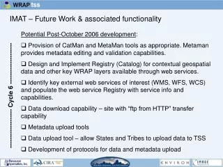
IMAT – Future Work & associated functionality Potential Post-October 2006 development: • Provision of CatMan and MetaMan tools as appropriate. Metaman provides metadata editing and validation capabilities. • Design and Implement Registry (Catalog) for contextual geospatial data and other key WRAP layers available through web services. • Identify key external web services of interest (WMS, WFS, WCS) and populate the web service Registry with service info and capabilities. • Data download capability – site with “ftp from HTTP” transfer capability • Metadata upload tools • Data upload tool – allow States and Tribes to upload data to TSS • Development of protocols for data and metadata upload ------------------- Cycle 6 --------------------
IMAT – Future Work: Data Access Add/enhance capability for integration (linking to external sources, enabling user input) and access to monitoring, modeling, emissions data in db and GIS layer formats. • Utilize Registry for menued selection to add key web services • Develop protocols and tools for data upload and integration. • Provide data through standard open interfaces (WMS, WFS, WCS) and in formats that facilitate uptake in GIS systems for maximum flexibility in display and/or further analysis. • Data download capability – develop tools and web pages that utilize the AOI functionality and the indexed data. Steps: • user identifies AOI • user selects data set for download, and selects output format • indexed data in TSS/CIRA RDBMS churns out selection • Potential output formats: shapefiles, SDTS, GML, ASCII, etc.
Current Indexing between spatially-related TSS layers Monitoring (point data) Emissions (point data) Emissions (area data) Modeling (area data) Data Boundaries IMPROVE site region County Class I Areas MSA 12 km Tribal Areas States RPOs Public Lands Other RPO Grid (36 km cell) Countries Management Political & Demographic
Future Indexing between spatially-related TSS layers Monitoring (point data) Emissions (point data) Emissions (area data) Modeling (area data) ? Data ? IMPROVE site region County Class I Areas MSA 12 km Tribal Areas States RPOs Public Lands Other RPO Grid (36 km cell) Countries Management Political & Demographic Boundaries
Future Work: Integrating additional external geospatial information and services • maintain and update access to web services for contextual data • solicit input on other useful external air quality and contextual data, e.g.: WMS • MODIS products (NASA TERRA and Aqua platforms) • LANDSAT Global Mosaic (NASA - JPL) • Shaded relief (UGSS) • GEOMAC Fire Locations –– 2002-present fire locations • WFS • Bureau of Census WebTIGER boundary features • WCS • other gridded data • gazetteer, elevation look-up, coordinate look-up (any EPSG projection)
Future Work: Refining and Augmenting Metadata to maximize ROI and add functionality to TSS • proceed with proposed template and protocols – see how it works – shortcomings will become apparent • add metadata elements as required, e.g., “Processing_Step” • standardize Attribute codes • publish to the National Spatial Data Infrastructure (NSDI) • utilize metadata catalog to access and display certain metadata elements (e.g., Abstract, Attribute_Definition) from XML records in customized manner to inform tool use • …?

![What is an IC ? [integrated circuit]](https://cdn0.slideserve.com/59701/slide1-dt.jpg)