Geospatial Problem-Solving System Integration: A Participatory Approach
This project focuses on integrating geospatial problem-solving capabilities into a comprehensive system for scientific requirements. By addressing business, system, software design, and application needs, the goal is to enhance participatory decision-making. The synthesis involves web surveys, CyberGIS integration, and utilization of user-friendly devices and portals.

Geospatial Problem-Solving System Integration: A Participatory Approach
E N D
Presentation Transcript
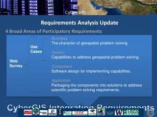
Requirements Analysis Update 4 Broad Areas of Participatory Requirements • Business • The character of geospatial problem solving. • System • Capabilities to address geospatial problem solving. • Component • Software design for implementing capabilities. • Application • Packaging the components into solutions to address scientific problem solving requirements. Use Cases Web Survey CyberGIS Integration Requirements
Requirements Synthesis Example EM.BUC.1 Wildfire Evacuation Triggers • Yan’s Comment: This table is a good starting point, but it only lists what current system use cases claim to have. This is what I think we can do to enrich this section: • Go back to our proposal to find more details of each existing software to make the list of applicable software elements more complete. • From business use case, derive capability requirements on CyberGIS based on web survey synthesis results. • Then ask each software provider to check what they have, will have, would like to have in CyberGIS project. I believe we have most of capabilities, but the challenge is on integration.
End Users Devices Portals Applications Business Requirements Service Providers Model Standards Service Consumers Tech Standards System, Component, Application Requirements Spatial Middleware Service Registry Integration Requirements Generic CyberInfrastructure
PGIST Review Components for participatory decision-making: BCT/CCT/CST Brainstorm Concerns / Categorize Concerns / Concerns Synthesis Tools Components currently encapsulated in a web application (VCC - Voicing Climate Concerns) but methods available via JavaScript libraries. LIT (Let’s Improve Transportation) is an earlier version of the BCT/CCT/CST LIT Workflow VCC Workflow