Cloud Lightning from the National Lightning Detection Network (NLDN)
150 likes | 283 Vues
This report explores the significance of low frequency (LF) cloud lightning data within the National Lightning Detection Network (NLDN). It highlights how LF cloud lightning often occurs before cloud-to-ground (CG) strikes in thunderstorms, with detection rates varying significantly based on storm intensity. Key aspects include the spatial representation of lightning activity, validation of LF cloud performance, and the challenges of detecting LF cloud flashes within the existing CG-optimized network. Data insights illustrate the complexities and advancements in understanding cloud lightning phenomena.

Cloud Lightning from the National Lightning Detection Network (NLDN)
E N D
Presentation Transcript
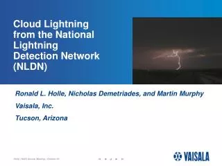
Cloud Lightningfrom the NationalLightningDetection Network(NLDN) • Ronald L. Holle, Nicholas Demetriades, and Martin Murphy • Vaisala, Inc. • Tucson, Arizona
Outline -- Value of LF cloud data-- Overview of LF cloud data-- Spatial representation of lightning activity-- Validation of LF cloud performance
Low frequency (LF) cloud data in the NLDN • Low frequency (LF) cloud lightning is typically located near cloud-to-ground (CG) lightning • Cloud lightning precedes CGs in ~70% of all thunderstorms • Cloud lightning typically precedes CGs by several minutes, but can precede CGs by > 60 minutes in some severe thunderstorms • Cloud flash rates are typically 3 times larger than CG flash rates, but may be >10 times larger in some severe thunderstorms
Outline -- Value of LF cloud data -- Overview of LF cloud data-- Spatial representation of lightning activity-- Validation of LF cloud performance
Low frequency (LF) cloud lightning data in theNational Lightning Detection Network (NLDN) • Activated April 2006 to all users • Detection methods are based on independent validation studies • Weak positive cloud-to-ground (CG) flashes less than +15kA are now identified as cloud flashes, not as CGs • 1/3 of the NLDN datastream is now LF cloud • A network configured for optimal detection of CGs on a national level will not detect most LF cloud flashes
The main challenge for LF cloud lightning detection:Source signal strengths All cloud Large cloud CG The median LF large cloud pulse amplitude is 5% as strong as for CGs A network configured for optimal detection of CGs on a national level will not detect most LF cloud flashes
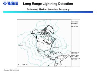
LF cloud data - NLDN • The vertical component of the cloud flash is located with a median accuracy of 500 meters • Cloud data are available in both the CG flash and CG stroke datastreams • A fraction of all cloud flashes that occur can be detected by the NLDN - the detection efficiency (DE) is typically 5-15% with the standard sensor spacing of the NLDN • LF cloud does not provide mapping of cloud lightning
Outline -- Value of LF cloud data -- Overview of LF cloud data-- Spatial representation of lightning activity-- Validation of LF cloud performance
LF cloud lightning detection data - Flash level Dallas- Fort Worth region Blue: Total VHF lightning mapping (1190 sources) Red: LF cloud lightning (5 sources)
Green: NLDN CG flashes - Sources at storm levelRed: NLDN-based test network LF cloud sources LF cloud flashes are typically located near the flash initiation point Dallas- Fort Worth region 18-minute period
VHF total lightning mappingAreal coverage of flashes at the storm level Dallas- Fort Worth region 18-minute period
Outline -- Value of LF cloud data -- Overview of LF cloud data-- Spatial representation of lightning activity-- Validation of LF cloud performance
The main challenge for LF cloud lightning detection:Source signal strengths All cloud Large cloud CG The median LF large cloud pulse amplitude is 5% as strong as for CGs A network configured for optimal detection of CGs on a national level will not detect most LF cloud flashes
LF cloud validation with LDAR II VHF mapping networkIsolated storms,Dallas/Fort Worth, close NLDN spacing Date Storm LDAR NLDN LF Relative Modeled flashes cloud DE (%) DE (%) 01 May 04 A 431 72 17% 15-25% 01 May 04 B 91 35 38 25-30 01 May 04 C 275 101 37 25-30 13 May 04 39 9 23 25-30 DE = detection efficiency
The end Photo by James Gluba, Bloomington, IL