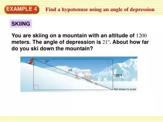
Estimating Distances Using Scales on Maps: A Guide with Ohio Examples
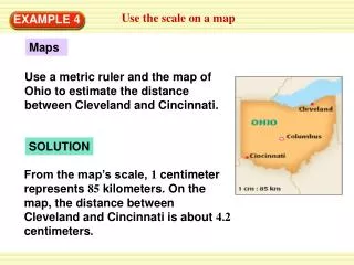
Learn how to accurately estimate distances on maps using scales. This guide demonstrates how to measure the distance between major cities in Ohio, specifically Cleveland and Cincinnati, using a metric ruler. By understanding the map scale (1 cm = 85 km), you'll be able to calculate distances effectively. The example provided shows that the distance between Cleveland and Cincinnati is approximately 357 kilometers. Additionally, similar methods can be applied for measuring distances between other cities, like Columbus and Cleveland, and even for model ship dimensions.

Estimating Distances Using Scales on Maps: A Guide with Ohio Examples
E N D
Presentation Transcript
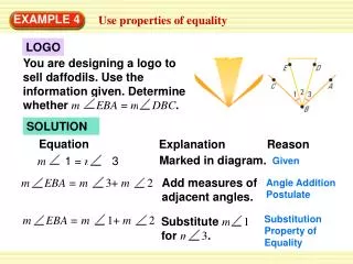
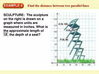
Maps Use a metric ruler and the map of Ohio to estimate the distance between Cleveland and Cincinnati. SOLUTION From the map’s scale, 1 centimeter represents 85 kilometers. On the map, the distance between Cleveland and Cincinnati is about 4.2 centimeters. Use the scale on a map EXAMPLE 4
1 centimeters = 85 kilometers 1 d = 85 4.2 ANSWER 4.2 The actual distance between Cleveland and Cincinnati is about 357 kilometers. d Use the scale on a map EXAMPLE 4 Write and solve a proportion to find the distance d between the cities. Cross products property d = 357 Simplify.
5. Use a metric ruler and the map in Example 4 to estimate the distance (in kilometers) between Columbus and Cleveland. ANSWER about 212.5 km Use the scale on a map EXAMPLE 4 for Example 4 GUIDED PRACTICE
6. The ship model kits sold at a hobby store have a scale of 1 ft : 600 ft. A completed model of the Queen Elizabeth II is 1.6 feet long. Estimate the actual length of the Queen Elizabeth II. ANSWER about 960 ft Use the scale on a map EXAMPLE 4 for Example 4 GUIDED PRACTICE Model ships