Regional Geography
Regional Geography. 5 th Year Geography Leaving Cert Exam Questions 4 , 5 and 6 – 3 questions to do one! . Long Term Learning Objectives. Define the term ‘region’. Discuss this definition using a number of headings – ‘ The Concept of a Region’.

Regional Geography
E N D
Presentation Transcript
Regional Geography 5th Year Geography Leaving Cert Exam Questions 4 , 5 and 6 – 3 questions to do one!
Long Term Learning Objectives • Define the term ‘region’. Discuss this definition using a number of headings – ‘The Concept of a Region’. • Learn about economic activities in two Irish regions – core and a periphery. • Learn about economic activities in two European regions – core and periphery. • Learn about a sub continental region – India. • Understand the characteristics of an urban region and problems associated with the region. Don’t Panic!! This is going to take us until the summer holidays to complete!
Outline of Work • Concept of a region – physical, administrative, cultural, socio economic, regions of industrial decline. • Irish Peripheral Region (BMW) – primary, secondary, tertiary economic activities, population and sketch map. • Irish Core Region (GDA) –economic activities, urban region Dublin, population and sketch map. • European Peripheral Region (Mezzogiorno Italy) –economic activities, population and sketch map. • European Core Region (Paris Basin, France) –economic activities, urban region Paris, population and sketch map. • Sub Continental Region (India) – economic activities, urban area Kolkata, population, culture and sketch map. • The complexity of Regions – (i) Impact of the EU (ii) Changing boundaries
Definition of a Region • What do you think a region is. In your groups discuss what you think a region is. • Definitions are to be written on the board.
Region • A region is an area with a characteristc(s) that sets it apart from other areas making it distinctive or unique in some way. • A region can be identified using a variety of characteristics such as landscape, climate, economic development, language religion or government.
Activity • In your groups and using the list below.. Discuss examples of regions that are identified by • Language • Landscape • Climate • Economic development • Religion • Government
Physical Region • Physical Region can be broken up into two parts • Climate – cool temperate oceanic (Ireland) • Landscape – Karst Landscape (Burren Co. Clare) and The North European Plain
Physical Region: Ireland’s Climate Cool Temperate Oceanic • 40 – 55 degrees north and south of the equator. • Ireland has mild winters (average 6°C) and moderately warm summers (average 15°C). • Rainfall is frequent throughout the year (1,500mm) with more rainfall in winter.
Physical Region: Ireland’s Climate Cool Temperate Oceanic Influence of latitude on Ireland’s climate Located between 51.5 and 55.5 ° north and south of the equator. This influences the amount of sunshine and the temperature. Influence of the sea on Ireland’s climate The sea warms and dampens the prevailing south westerly winds and keeps the coast ice free in winter. The sea acts as an enormous storage heater. This keeps land temperatures much higher than they should be given our latitude. Without the influence of the sea average winter temperatures in Ireland would be 10 degrees colder.
Physical Region: Ireland’s Climate Cool Temperate Oceanic The influence of south westerly winds on Ireland’s climate Winds pick up moisture and heat from the water as they travel across the Atlantic Ocean. The wind picks up water vapor by evaporation on its journey across the ocean. When the moist air reaches land it is forced to rise above the mountains causing relief rainfall.
Physical Region: Climate Activity: In groups, using the notes above and your book, summarise the main characteristics of the cool temperate oceanic climate.
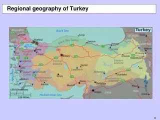
Geomorphic Regions (Landscapes) • Part of Physical Region – Karst Landscape Burren Co. Clare • North European Plain is a lowland area covering more than half of Europe including Poland, northern Germany, Belgium, northern and western France and the Romanian, Bulgarian and Hungarian plains.
Characteristics of the North European Plain • Soils – during last ice age glaciers deposited rock, sand and soil as moraine and boulder clay. Strong winds blew across these deposits and lifted fine sands and silt (limon). • Climate – mild and moist. Rainfall is evenly distributed throughout the year and temperatures are moderate. • Drainage – Many large rivers such as the Seine, the Rhine and the Loire flow across in a north westerly direction. • Relief – Flat relief has allowed intensive commercial agriculture and the development of efficient transportation networks.
Administrative Region • Areas controlled by local or central government agencies. • Local agencies are town councils and county councils – Ireland county councils • Central agencies are government departments – France Departments
Let’s think about how Ireland is governed…. Thought shower!!
Activity: In your groups read the case study of local and central government agencies in Ireland • Highlight the important pieces of information. • Summarize the main points into your copies.
FRANCE - ADMINISTRATIVE SYSTEM • Multiple Tier System • Central Government • 22 Regional Governments • 92 Departments
France Government • Like Ireland France has a three level local government administration system. • Communes • Departments • Regions
Communes • 1798 – oldest form of local authority in France. • Responsible for water supply, lighting, park maintenance and primary school buildings. • Each has an elected mayor and assembly. • Similar in size to small Irish towns, villages and parishes. Most have less than 1,000 people.
Departements • 1790 • Responsible for planning, public housing, car tax, secondary schools and colleges, roads, health and social services. • There are 100 departements in France. All are a similar size and shape. The prefet is the government representative in his/her local departement. • Each departement is identified by a two digit number which is used on car number plates and postcodes.
Regions • Created in 1982 to decentralise government services and decision making. • Responsible for regional planning and economic development as well as funding schools and colleges. There are 26 regions and each region has a unique cultural identity. • Decisions are made by a regional council whose members are elected every six years. Similar to Irish provinces – connaught, munster etc.
Cultural Regions • What is culture? • In your groups discuss this…. • Write down some of the elements that you think make up someone’s culture.
Cultural Regions • Areas where people share a specific language, religion and/or way of life.. 2 headings – Language and Religion • Gaeltacht Ireland • Belgium’s language divide. • Protestantism in Northern Ireland • Islamic World.
Exam Question • Culture is an important factor in defining some regions. Examine the above statement with reference to any region you have studied. Can also add these notes into the concept of a region question.
Culture – Language: Gaeltacht • http://www.youtube.com/watch?v=liYWT7Ip0J4 • The Irish language has an important role in expressing Irish culture and identity. • Read your book on page 147 for a quick introduction. • (We will also study chapter 33 with this topic)
What do we know about the Gaeltacht and the Irish language? • Mind map everything we know about out national language.
Activity: Read the case study on the Gaeltacht – Answer the following questions • What is the Gaeltacht? Where is the Gaeltacht located? • Describe in detail how the Gaeltacht was formed. • What is the Fíor and Breac Gaeltacht? • Phyiscal and human factors have combined to make the Gaeltacht a unique cultural region. Explain this statement referring to physical and human factors. • Give three historic and three modern reasons why the Irish language has declined. • What is being done to support the Irish language.
Changing Boundaries in Language Regions Regional boundaries can change over time This is due to • Push and pull forces of migration • Effect of strong external forces. Activity: Read page 239 – 241 of your books to understand why the boundary of the Gaeltacht has changed.
Culture: Language • Belgium has a population of 10.6m people but is a linguistically divided country. The division of the population by language has led to political, social and economic division of the country. • An official language line occurs across the country separating Dutch speaking Flanders from the French speaking Wallonia.
Wallonia • Southern Belgium • French Speaking • Liberal • Socialist • Catholic • Locals are called Walloons. • Was once wealthy industrial region based on the coal resources (Sambre Meuse Valley) but went into decline in the 1960s. • High unemployment.
Flanders • Northern Belgium • Flemish – a variation of Dutch • 60% of Belgian population is Flemish. • Catholic but more conservative and republican in outlook. • Economy mainly based on agriculture with little industry but since 1960s Flanders has undergone economic growth. • Capital city Brussles is located in Flanders.
The language line was established in 1917 and led to the formation of two government administrative regions. (Each have their own government) • A third region, The East Cantons, is German speaking. • Representatives from each region are elected to the Belgian national government.
Groupwork • As a group read the case study on Belgium. • Discuss the phyiscal or human factors that have led to the division of Belgium. • Summarise these in you copies. • Share your work with the other groups.
Culture: Religion • Religion can also make regions unique. It can shape group identity and act as a unifying force but can equally be a source of social conflict and can strongly divide people. We are going to look at two case studies Ireland – Protestantism in Northern Ireland The Islamic World.
Keywords • Protestant • Catholic • Unionism • Loyalism • Republican • Nationalist
Protestantism in Northern Ireland • Plantation of the area during the 16th and 17th centuries. Settlers came from Scotland and England • Protestant religion was a unifying cultural force (brought them all together) which separated them from the native Irish Catholic. • Over time their religion became associated with their political struggle to remain park of the UK as expressed in unionism and loyalism. • Catholicism became associated with the struggle to reunify Ireland as expressed in republicanism and nationalism.
The conflict in Northern Ireland is between two groups; Protestants and Catholics. The conflict is not necessarily about religion, but it does have some significance in the history of the conflict. The current population of Northern Ireland is 1.5 million. 55% of the population is Protestant, 45% Catholic. Today, the two groups place their emphasis on different elements of the problem. Background Data
Protestant Beliefs • Have a constitutional right to the land • Preserving the Union with Britain • Resisting the perceived threat of a United Ireland
Catholic Beliefs • For some, Northern Ireland remains a National struggle • Self determination • Others viewed the conflict as a struggle against unfair practices by the Unionist government between 1920-1970
Historical Background • The proximity of Britain and Ireland has lead to a long history of interaction and linkage.
1170- Settlers from Britain arrive in Ireland 1608 -Plantation of Ulster began English and Scottish settlers moved into the north 1641- The Catholic-Gaelic rising in response to the Plantation and the confiscation of land by Protestant settlers from England and Scotland 1690- The Battle of the Boyne and the victory of Protestant William III over Catholic James II - this victory is still celebrated in many parades in Northern Ireland 1801- Act of Union which abolished the Irish Parliament and bound Ireland and Britain together as parts of the United Kingdom 1912 -Ulster Solemn League and Covenant signed by over 400,000 Protestants who wanted to remain in the Union 1916- The Easter Rising in Dublin against British rule Key Dates in Northern Ireland History