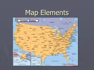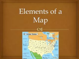

Map Elements
E N D
Presentation Transcript
Map Elements Write On
In this activity you will: • Learn about the elements of a map: latitude, longitude, the hemispheres, directions, time zone, scale, and map legends.
Latitude and Longitude • The earth is divided into lots of lines called latitude and longitude.
Lines • Longitude lines run north and south. • Latitude lines run east and west. • The lines measure distances in degrees. Latitude Longitude
Where is 0 degree? • The equator is 0 degree latitude. • It is an imaginary belt that runs halfway between the North Pole and the South Pole. Equator
P R I M E M E R I D I A N Where is 0 degree? • The prime meridian is 0 degrees longitude. 0%
Hemispheres • By using the equator and prime meridian, we can divide the world into four hemispheres, north, south, east, and west.
Compass • A compass is a tool that helps the user know what direction one is headed. • On a map, a compass helps the user locate their directions.
Magnetic North • The needle on a compass is magnetized to point to the earth's north magnetic pole. Thus with a compass, a person can roughly tell which direction is north, not true north. Source: http://aerocompass.larc.nasa.gov
Directions • The four directions are north, south, east, and west. • The intermediate directions are northeast, southeast, southwest and northwest. • They help describe the location of places in relation to other places.
Scale • Maps are made to scale; that is, there is a direct connection between a unit of measurement on the map and the actual distance. • For example, each inch on a map represents one mile on Earth. So, a map of a town would show a mile-long strip of fast food restaurants in one inch.
Time Zones • The Earth is divided into 24 time zones, corresponding to 24 hours in a day. • As the earth rotates, the sun shines in different areas, moving from east to west during the course of a day. • Places that have the same longitude will be in the same time zone.
Religions Legend Map Legends • The legend is the key to unlocking the secrets of a map. Objects or colors in the legend represent something on the map.
Legend Age Expectancy