Download
1 / 16

E N D
WP 1 Status(TUM) Bernhard Felbermeier
WP 1 • Transnational data collection and identification of CADSES cross-border territorial areas of intensive monitoring (target areas) will be identified for the collection experimental data and for the testing of the application of possible models. Selected territories will be representative of the whole CADSES area, and they will consist in: • mountain forests, represented by natural forests (especially in the Balkan area) and mature alpine forests, closer to natural forests; • agro-forestry surfaces of the fluvial Danube lands; • Mediterranean forests; • fast growing forests in agricultural areas (poplar-growing) • For each of the systems selected in WP1 a set of information will be collected: • studies • researches • management plans • statistical information, etc. • in order to define: • the characteristics of the areas to be analysed and the management methods used; • the available data referred to carbon cycle for the target areas or, if they do not exist, for similar areas. • Experiences and models for the management of the natural resources eventually implemented in the selected target areas (results and findings of LIFE projects experiences of coordinated management of the forest-wood-energy chain, projects and experiences for the sustainable use of biomasses and application of alternative energy systems, etc.).
Act. 1.1 (PP1) Transnational Technical Board • TTB 1 (I-FVG): • common transnational approach to the data collection • standards for the identification of representative areas of intensive monitoring; • TTB 2 (D-TUM): • evaluation of the results of the WP1 • validation of the MAP • planning of the activities to carry out in the WP2 • Act.1.2 (PP4) Transnational harmonization of existing methodologies (design of a common framework on available models) and data recognition • Cross border identification of gaps and opportunities towards the completion of the carbon balance. • Data collection supported by results of European and national scientific researches
Act. 1.1 (PP1) Transnational Technical Board • TTB 1 (I-FVG): • common transnational approach to the data collection • standards for the identification of representative areas of intensive monitoring; • TTB 2 (D-TUM): • evaluation of the results of the WP1 • validation of the MAP • planning of the activities to carry out in the WP2 • Act.1.2 (PP4) Transnational harmonization of existing methodologies (design of a common framework on available models) and data recognition • Cross border identification of gaps and opportunities towards the completion of the carbon balance. • Data collection supported by results of European and national scientific researches
Act. 1.3 (PP5) Analysis for the identification of representative cross border areas/territories of intensive monitoring for the carbon cycle. Selected territories will be representative of the whole CADSES area, and they will consist in: • mountain forests, represented by natural forests (especially in the Balkan area) and mature alpine forests, closer to natural forests; • agro-forestry surfaces of the fluvial Danube lands; • Mediterranean forests; • fast growing forests in agricultural areas (poplar-growing). • Outputs obtained from WP1 • Act. 1.1: Common transnational Guidelines on how to match models to collect datas, 1 Mainstreaming Action Plan validated; • Act. 1.2: A database of documents on data, existing management models, research projects’ results, etc.; • Act. 1.3: A database of representative cross border CADSES territories with mountain forests, agro forestry surfaces, Mediterranean forests, fast growing forests.
Act. 1.3 (PP5) Analysis for the identification of representative cross border areas/territories of intensive monitoring for the carbon cycle. Selected territories will be representative of the whole CADSES area, and they will consist in: • mountain forests, represented by natural forests (especially in the Balkan area) and mature alpine forests, closer to natural forests; • agro-forestry surfaces of the fluvial Danube lands; • Mediterranean forests; • fast growing forests in agricultural areas (poplar-growing). • Outputs obtained from WP1 • Act. 1.1: Common transnational Guidelines on how to match models to collect datas, 1 Mainstreaming Action Plan validated; • Act. 1.2: A database of documents on data, existing management models, research projects’ results, etc.; • Act. 1.3: A database of representative cross border CADSES territories with mountain forests, agro forestry surfaces, Mediterranean forests, fast growing forests.
Procedures • Selection of datasets (finished in Dec) • Download of datasets (finished in Dec) • Update: • Download dataset from online-database • Improve dataset • Email to Felbermeier@lrz.tu-muenchen.de • Update of database by TUM • Append new data • Download dataset from online-database • Delete old data and add new data in the dataset • Email to Felbermeier@lrz.tu-muenchen.de • Append new database of database by TUM
Status of spatial database • Maps collected by TUM on EU-scale: • Climate • Soil (Western Europe) • Carbon • CORINE • NUTS • Maps to be collected by partners on CBA scale: • Climate • Soil • Potential vegetation • Land use management • Forest management
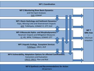
Monitoring & inventory Education & capacity building WP 2 Research Center Research plots & carbon estimation