Download
1 / 48
530 likes | 996 Vues
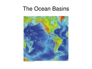
The Ocean Basins. Ocean Basins. Oceans are all connected, so it’s really just 1 big ocean! 5 ocean basins Atlantic Pacific Indian Antarctic (Southern) Arctic (northern extension of the Atlantic). Ocean Basins. How old are the Earth’s Oceans?.

E N D
Ocean Basins • Oceans are all connected, so it’s really just 1 big ocean! • 5 ocean basins • Atlantic • Pacific • Indian • Antarctic (Southern) • Arctic (northern extension of the Atlantic)
How old are the Earth’s Oceans? • Oldest rock formation found on Earth dated at about 4 billion (4,000 million years old) • These rocks were deposited in an ocean environment • Recall Earth is about 4.5 billion years old)
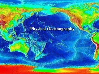
The Earth’s Oceans • cover 71% of the Earth’s surface • 2-11 km (1-6 miles) in depth (~5 km or 3 miles average) • 1.4 billion km3 (310 million cubic miles) water volume • Where did it all come from?
Origins of the OceansFrom the inside out: Volcanic Outgassing • Water vapor and other gases trapped within Earth as it formed, • Volcanic eruptions, which emit water vapor and gas, more plentiful in the geologic past, • Much of this lost to solar wind. Accounts for perhaps 10% of the Earth’s atmosphere and ocean material.
Origins of the Oceans From the outside in: Cometary Water • Volatiles lost from the Earth and other inner planets combined with debris from formation of solar system to form comets. • Comets are composed mainly of rock and frozen gases, including water. • Early solar system had many more comets than today. • Current popular hypothesis is that atmosphere and oceans formed from impacts with comets and other planetary debris.
Oceanic crust and Continental crust • Oceanic crust is younger; oldest age found is 200 million years and most is less than 60 my (why is that?) • Much continental crust over one billion years old! • Oceanic crust is mostly basaltic; continental crust is mostly granitic. • Oceanic crust is denser – due to the iron content of basaltic magma.
Oceanic crust and continental crust • Ocean crust is thinner – 4-7 km versus 20-40 km for continental crust. • Continental crust sits much higher on the surface of the Earth. • And yes, oceanic crust is usually wetter.
Mid-Ocean Ridges Mid-Atlantic Ridge Mid-Indian Ridge East Pacific Rise
Deep Ocean Trench at Oceanic-Oceanic Boundary (e.g. Marianas Trench)
Radar Image of Deep Ocean Trenches at Boundary of Pacific Plate • From North to South • Aleutian Trench • Kurile Trench • Japan Trench • MarianaTrench (curved) • Philippine Trench (between Philippine Plate and Eurasian Plate) • The long purple line south of the Aleutian Trench is the Emperor Seamounts
Studying the Sea Floor – Direct Methods • Rock dredge – open-mouth steel net dragged along the ocean floor • Coring – a pipe is used to collect a mud or sediment core
Studying the Sea Floor – Direct Methods • Sea-floor drilling – similar to equipment used for off shore oil drilling
Studying the Sea Floor – Acoustical and other Remote Methods • Echo sounding – used to map sea-floor topography (SONAR) • Submersibles – both manned and robotic
Studying the Sea Floor – Remote Methods • Seismic Profiler – like sonar, but higher-energy waves penetrate sea-floor and image the subsurface • Magnetometer – towed behind ships to record magnetic fields of rock • Microwave radar – used to map sea-surface, surface mimics sea-floor topography
Seawater Composition and Salinity • The salt content or salinity is around 3.5%, most being NaCl, with lesser amounts of KCl, bromides and carbonates. • The dissolved material in sea water comes from • Weathering of rock and transport to sea by rivers • Volcanic activity • “Black smokers” at mid-ocean ridges
Seawater Composition and Salinity • Evaporation and freezing tend to concentrate salt in sea water • Arctic Ocean, Mediterranean Sea • Salt is removed by biological organisms • Sea water also receives an influx of fresh water from precipitation and river flow
3 Major Density Zones in the Ocean (controlled by temperature and salinity)
Current: continuous flow of water in a given direction Surface currents: caused by winds Winds blow in preferred directions due to differential heating of the earth’s surface Example of a surface current: Gulf Stream – 80km wide by 650m deep, up to 5km/hr. velocity Currents influence the climate (Labrador vs. England)
Gyres - circuit of currents around the periphery of an ocean basin • Gulf Stream Current is part of the North Atlantic Gyre) • Caused by Westerlies and trade winds • Trade winds blow from the northeast in the or southeast in the tropics • Westerly winds (westerlies) blow from the northwest or southwest in the mid-latitudes
Gyres • Gyres circulate clockwise in the northern hemisphere • Gyres circulate counterclockwise in the southern hemisphere
Surface Ocean Currents • Currents on the west side of the ocean basin (i.e. east side of continent) originate in the tropics and are warm-water currents • Examples: Gulfstream, Brazil Current • Currents on the east side of the ocean basin (i.e. west side of continent) originate at the poles and are cold-water currents • Examples: California Current, Humbolt Current (cause of El Nino)
Deep-Ocean Currents- Thermohaline Circulation • caused by density differentials • Temperature: cold water is more dense than warm and will sink • Salinity: saltier water is denser than fresh water and will sink • Deep-ocean currents are connected to the surface current system • Increased freshening of polar waters is changing thermohaline circulation patterns. What is the effect on surface currents?
Great Ocean Conveyor Belt Near Greenland, water becomes very dense due to salinity and sinks This allows the North Atlantic Drift to continue toward Northern Europe. Global warming may shut this down Disastrous consequences for Europe!
The diagram shows the South Pacific during a normal year. • Strong S. Pacific Equatorial Current reinforces the northward-flowing Humbolt Current • This promotes upwelling of cold, nutrient-rich water, which supports the S. American fishing industry
An El Nino Event (ENSO) • Occurs every 3-7 years for a year • Weakens trade winds and S. Pacific Equatorial current • This in turn weakens the Humbolt Curent which reduces cold upwelling • This creates warmer surface water, depresses the fishing industry and changes weather patterns in many places.
Consequences of El Nino Anomalous warm water off the coast of South America • Increased storm activity in many parts of the U.S and northwestern Europe • Drought in Australia and S.E. Asia
If the Labrador Current (Cold) is too fresh to sink, it may block passage of the N. Atlantic Drift (warm) which moderates the climate of Great Britain and Scandinavia
Global warming and sea-level rise • Sea-level has risen and fallen in the past • Past 40,000 yrs, 150m fluctuation • More recently, sea-level is rising ~3mm/yr • Warming temperatures raise sea level by • Thermal expansion of water • Release of glacial water that was on land • Some low lying coasts and islands are already feeling effects
Tides • Both the Earth and the Moon revolve around a point located in the interior of the earth, near point A. • The solid Earth is not affected, but the water forms 2 permanent bulges.
Tides • Bulge “A” caused directly by gravitational attraction of moon. • Bulge “B” caused by inertia of water as earth swings inward toward the moon (“centrifugal force”).
Tides • As the earth rotates, shorelines pass through each bulge approximately 12 hours apart. • Other influences include: • Gravitational effect of the Sun • Shape of the coastline
Spring and Neap Tides • Spring tide – highest tides, occur when Earth, Sun & Moon are in alignment • Neap tide – lower high tide, when Earth, Sun & Moon form a 90o angle