Download
1 / 8
80 likes | 192 Vues
Explore how changing zone boundaries impact transportation analysis, land use data aggregation, and future network planning. Collaborate with agencies, identify key contacts, and coordinate data acquisition efforts.

E N D
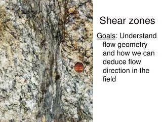
Transportation Analysis Zones Changing Boundaries For Our Future
Purpose of the Zone • Determines the granularity of the supported network • Used to aggregate useful land use and census data for modeling • Constrained by physical features (natural and manmade) and census subdivisions • Single source of data for base and future year modeling • May nest within other modeled areas or provide the basis for sub-area analysis
Zone Modifications • Changing census block definitions • New freeways or other barriers • Land use changes or special generators • Need for increased or decreased network granularity • Nesting for other agency modeling efforts (e.g. Collar Counties, Statewide)
Getting New Data • What data do you require now? Use super-TAZs to avoid suppression? • What data might you require in the future if your modeling practices change? • If you have TAZ boundaries that nest with another agency’s TAZ boundaries, which agency defines the TAZs for both agencies? • What information technology will you use? (TIGER/TAZ-up software, GIS, tables, …)
Sherburne County (one collar county) St. Cloud Area
Will there be more nesting or overlapping jurisdiction issues? Y E S Metropolitan Areas Expand, Even Across State Lines
Perhaps You Can Help • Identify potential future planning area overlap • Share names of key contacts - Wisconsin DOT, Minnesota DOT, State Demographer, MPOs, … • Determine what data are needed & where • Decide who does what and at what scale • Coordinate our efforts with state and federal agencies in order to obtain data • Other actions?
If we make corrections or adjustments to the data we need to share that with our ‘nesting partner’. What worked well last time? It’s still early. ? What about our external stations? What should we watch out for this time? There are new challenges out there.