Download
1 / 5
50 likes | 221 Vues
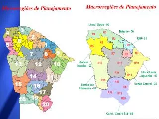
Macrorregiões de Planejamento. 3. 4. 2. 6. 5. 1. 9. 7. 8. 13. 12. 10. 14. 11. 15. 17. 19. 18. 20. Microrregiões de Planejamento. 16. MODELO DA SEPLAN DE REGIONALIZAÇÃO: EXISTÊNCIA DE 8 MACRORREGIÕES DE PLANEJAMENTO. MR 1 RMF 1 micro 13 municípios.

E N D
Macrorregiões de Planejamento 3 4 2 6 5 1 9 7 8 13 12 10 14 11 15 17 19 18 20 Microrregiões de Planejamento 16
MODELO DA SEPLAN DE REGIONALIZAÇÃO: • EXISTÊNCIA DE 8 MACRORREGIÕES DE PLANEJAMENTO. • MR 1 RMF 1 micro 13 municípios. • MR 2 LIT.OESTE 3 micros 27 municípios. • MR 3 SOBRAL / IBIAPABA 2 micros 29 municípios. • MR 4 INHAMUNS 2 micros 16 municípios. • MR 5 SERTÃO CENTRAL 3 micros 21 municípios. • MR 6 MACIÇO BATURITÉ 1 micro 13 municípios. • MR 7 LIT.LESTE / JAGUAR. 3 micros 23 municípios. • MR 8 CARIRI / CENTRO SUL 5 micros 42 municípios.
Acaraú Camocim Itapipoca Sobral Fortaleza Tianguá Centro Primaz Baturité Centro Secundário Aracati Canindé Centro Regional Russas Russas Crateús Quixadá Morada Nova Limoeiro do Norte Quixeramobim Tauá Jaguaribe Iguatu Campos Sales Juazeiro do Norte Crato Brejo Santo Barbalha DesenvolvimentoLocal e Regional • Melhor Distribuição Territorial da Renda e do Emprego • Inclusão Social Territorialmente Equilibrada • E = 1 P + 4 S + 13 R E = 18 N
MODELO DE DESENVOLVIMENTO REGIONAL DA SDLR: • INDICADORES: • TAMANHO DA POPULAÇÃO DO MUNICÍPIO, ONDE SE SITUAM OS CENTROS. • TAXA DE URBANIZAÇÃO > 60%. • PIB per capita _> 40% do PIB per capita de Fortaleza. • TAXA DE CRESCIMENTO ANUAL (1991/2000) _> 1,5% a.a. • CLASSIFICAÇÃO BASEADA NO ÍNDICE GLOBAL DO IDM.
DÚVIDAS DO PROCESSO DE REGIONALIZAÇÃO: • PORQUE EXISTEM TANTAS REGIONALIZAÇÕES NO ESTADO? • QUE VANTAGENS / DESVANTAGENS ISSO TRAZ PARA A GOVERNANÇA? • ESSAS REGIONALIZAÇÕES GUARDAM CORRELAÇÃO ENTRE SI? • QUE METODOLOGIAS FORAM UTILIZADAS PARA O ESTABELECIMENTO DESSAS REGIONALIZAÇÕES? • HÁ SEMELHANÇA ENTRE O MODELO DO IBGE PARA O ESTADO E ESSAS OUTRAS REGIONALIZAÇÕES? • REGIÃO HOMOGÊNEO SEMELHANTE ?