Download
1 / 24
240 likes | 469 Vues
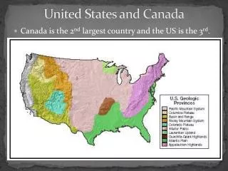
The United States and Canada. Migration . People migrated to the US & Canada from Europe for many reasons: Religion Economics: to make more $$ Jobs ( in factories and building railroads) L and Economic growth and opportunity War. US & Canadian Physical Geography.

E N D
Migration People migrated to the US & Canada from Europe for many reasons: • Religion • Economics: to make more $$ • Jobs (in factories and building railroads) • Land • Economic growth and opportunity • War
US & Canadian Physical Geography Human Environment Interaction • Movement westward altered the land in both the U.S. and Canada • Transportation networks helped develop the land and economy of the region.
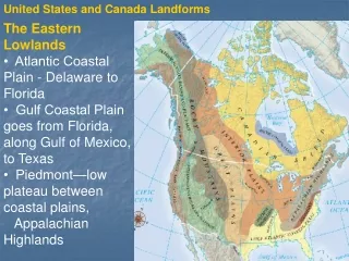
Appalachian Mountains Rocky Mountains Largest & youngest! mountain range in North America. Stretches from Alaska to Mexico. Stretches from eastern Canada to western Alabama. Oldest mountain range on the continent.
The Mississippi: America’s Great River Road • Longest River in North America
Grand Canyon • Carved out by the Colorado River over a 5 million year time span. • Over 1 mile deep • Recent estimates say that the canyon is over 17 m yrs old Continental Divide: Separates the watersheds that drain into the Pacific from those that drain into the Atlantic .
Great Salt Lake (Utah) • 6 times saltier than the oceans!
Death Valley, CA • 3,000 sq miles • Lowest, hottest & driest place in N. America
Population Patterns Where has population shifted over time? East to West Human-Environment Interaction • Railroads and interstate highways opened/connected new areas • Rivers, dams, bridges, canals, and irrigation made water resources more useful • People live near key resources
Politics & Economics • Political System in the US: Federal Republic • US gained freedom from England in 1776. • Economic System: Mixed/Free Enterprise
Economics - Demographics • How would you describe the level of development of the U.S.? • More developed • Where does the U.S. rank in the Human Development Index? • NUMBER FOUR • HDI is based on the data collected in the chart to the left
The U.S. • Urbanization centered around rivers and ports • Culturally diverse • Midwest is agricultural
How do you think the US influences culture around the world?
What do you think a former Canadian Prime Minister meant by this statement aimed at the US: "Living next to you (the US) is in some ways like sleeping with an elephant. No matter how friendly or temperate the beast, one is affected by every twitch and grunt.“ Cultural Protectionism: In response to American popular culture, and its overreaching effect in Canada, Canada has imposed “protectionism” policies to limit the effect of foreign culture on its domestic audience.
Canadian Colonization: • Beginning in the 14th & 15th century, British, French & Spanish expeditions explored the Eastern Coast and Hudson Bay area & later settled in this region.
Continental Expansion & The Transcontinental RailRoad • Shortly after the transcontinental RR was completed (1869-1885) gold was found in Yukon which brought people from all over the world seeking their fortune. • Result: many towns developed along the RR route: Near the US Canadian border.
Population Distribution • Population is 31.6 million & growing (putting it in perspective: US population = 350 mill) • Most of the population is centered near the US/Canadian border. Why??
Canada is one of the top 10 wealthiest nations in the world. Economic System: Mixed/Socialism Canada is a member of NAFTA (North American Free Trade Agreement) along with the US & Mexico.
Where do you see most of the economic activities (both Agriculture & Industry) in Canada? Why? Along the US/Canada border, because this is where the climate is more mild, and where the natural resources are located.
Governing Canada • Canada was recognized as an independent nation by Britain in 1931. • Parliamentary Government • Canada is independent but it’s symbolic head of state remains the British Monarch.
Canadian Shield • A very thin layer of soil lying on top of the bedrock, with many bare outcrops. • Is a result of glaciation. • The CS is rich in mineral deposits, scarcely populated.
Canadian Provinces & Territories • Canada = 10 Provinces & 3 Territories. • Major Cities: Quebec, Toronto & Montreal • Capital City: Ottawa • Quebec (province): former French colony, that still has strong cultural ties to France. Nunavut: territory given to Inuit population (Natives).