Download
1 / 13
130 likes | 304 Vues
Integrated Upper-Air Observing System (IUOS) and the Adaptive Radiosonde Launch Strategy. David Helms NWS Office of Science and Technology. NOAA/NWS Partners Meeting June 6, 2006. Outline. What is IUOS? Mission Objectives Requirements Definition Roadmap

E N D
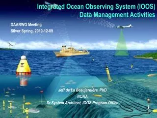
Integrated Upper-Air Observing System (IUOS) and the Adaptive Radiosonde Launch Strategy David Helms NWS Office of Science and Technology NOAA/NWS Partners Meeting June 6, 2006
Outline • What is IUOS? • Mission • Objectives • Requirements Definition • Roadmap • IUOS Phase 1: Regional In Situ Soundings • Notional Plan • Assessment Timeline • Weather Enterprise Input • Future Directions: In Situ Observations • Radiosonde • Commercial Aircraft
What is IUOS?Mission and Requirements Space • IUOS Mission: Cost-effectively meet existing NOAA upper-air observation requirements; and future validated requirements for: • Improved spatial, temporal, and spectral resolution • New observations of environmental parameters • Data Management and Communications (DMAC) • Upper-air observation requirements space: • Geographical Extent: Global • Vertical Extent: 10 m above surface to Sun • Temporal Range: Warnings to Global Climate Change Prediction • Parameters: Winds, temperature, pressure, moisture, air chemistry, reflectivity, aerosols, biology, ….
IUOS Platforms and Sensors What is IUOS?Objectives • IUOS solution characteristics – Future IUOS will be: • Adaptable, extensible, stable, continuous, and quality assured • Cost-effective – avoid unnecessary duplication • Serving multi-purposes - including driving Earth-system models • Consistent with/component of USGEO and GEOSS • Final Operating Capability: • “Optimal” mix of NOAA and non-NOAA observation platforms including bothin situ and remote sensors based on NOSA Architecture Principles
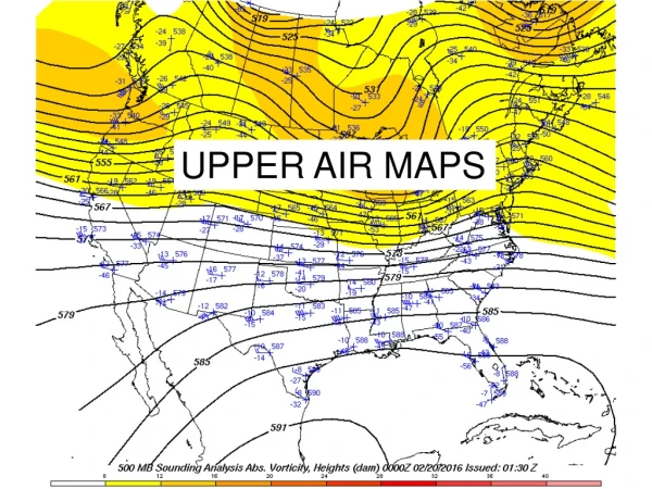
What are the IUOS Requirements? Methodology • Collect and Validate requirements • Surveyed Users • Scientific Literature • “Heritage” Requirements (e.g. FMH-3) • NOAA CORL (Program Input) • Phenomenological Analysis • Establish Requirements Domain • Threshold: Minimum performance operationally useful • Objective: Maximum operationally useful performance 70% of all requirements satisfied with atmospheric soundings collected every 2 hours 70% of all requirements satisfied with atmospheric soundings every 75 km
13 14 15 04 05 06 07 08 09 10 11 12 16 Requirements Phase 1 – Regional In Situ Soundings Analysis PPB Deploy FOC IOC Phase 2 – Integrated Regional Soundings Req’s Analysis PPB Deploy IOC FOC Phase 3 – Integrated Radar Req’s Analysis PPB Deploy FOC IOC IUOS RoadmapPhased Approach Incorporate Data Management Principles
IUOS Phase 1: Regional In Situ SoundingsRadiosonde/WV Aircraft Obs • In FY06-07: • Evaluate model response to water-vapor sensor derived data • Evaluate implications of • forecasters using different data source and, • reaction of broader US weather enterprise. • Use evaluation to develop plan for implementation • In FY08: Begin eliminating redundant capability for weather observations
Phase 1: Adaptive Sounding Strategy Notional Plan • Use alternative sounding from commercial aircraft if WV instrumented aircraft has a scheduled ascent or descent at an airport which is within: • XX miles of radiosonde site • YY minutes of radiosonde valid time • CONOPS: • Lead Meteorologist at closest WFO coordinates sounding strategy • Short (<3 hrs) and long term (6 month) public notices disseminated indicating product availability and associated WMO Heading and circuits • Soundings from aircraft publicly available in near real-time • Alternative sounding strategy limited to: • 1 of 2 sounding launches per radiosonde station (initially) • CONUS Non-GUAN stations • Outcomes: • $4M/yr in cost avoidance from radiosonde expendables • Redundant observations eliminated • Greater % of Data Requirements Achieved
Adaptive Sounding Strategy: Assessment Timeline • FY06-Q3: Statement of Need and Draft Project Plan generated (completed) • FY06-Q4: Draft CONOPS Outline, Operational Requirements Document, demonstration design, and evaluation plans for model, operational forecasters, comment from US Weather Enterprise community. • FY07-Q2-Q4: Site Demonstration, Test, and Evaluation (DT/E) • FY07-Q2: Nowcasting and Model Impact Assessment, Community Feedback • FY07-Q4 to FY08-Q1: Operational Test and Assessment (OT/E) • FY08-Q2: Initial Operating Capacity (IOC) for redundant radiosonde reduction (aka “adaptive radiosonde launch strategy”) • FY12: Full Operating Capacity (FOC)
Adaptive Sounding Strategy: Weather Enterprise Input • A few questions… • How do you currently use radiosonde observations? • What do you know about atmospheric observations from commercial aircraft? • What transition issues might you have with use of aircraft observations as an alternative to radiosonde observations? • How can NOAA best communication data quality issues associated with aircraft observations? • How does the proposed adaptive sounding strategy timeline impact you? • How can we recruit Weather Enterprise contacts to answer these and other issues associated with the Adaptive Sounding Strategy???
Future Directions: Radiosonde Program • Now: Radiosondes launched by the clock, 00 UTC and 12 UTC • Future: Launched as needed to best support NOAA mission, including • Co-incident launches to calibrate satellite observations • More special launches in support of high impact weather prediction • Launches timed to best describe diurnal solar impact for climate monitoring • Now: Observation quality useful for operational weather prediction • Future: Observation quality enhanced to better support climate monitoring • Now: Limited geo-physical parameters collected (wind/temperature/RH) • Future: Enhanced data collection (cloud properties, ozone, etc). • Bottom Line: • Capability to launch radiosondes will be maintained • Combination of observations from radiosonde, commercial aircraft, wind profilers, and other systems will result in a far greater amount of publicly available data than currently available • NOAA is committed to maintaining the Radiosonde Program as a key component of IUOS
Future Directions: Commercial Aircraft Observations • Now: • 25 WVSSII sensors on United Parcel Service B-757 aircraft since March 2005 (NOAA) • 60 TAMDAR sensors on Mesaba Saab 340 Aircraft since January 2005 (NASA) • 1-2 Months: NOAA RFP for Water Vapor Data from Commercial Aircraft • FY07-08: NOAA Phase I contract for sensor installation and data collection • FY08-12: NOAA Phase II contract for expanded sensor installation and data collection • Bottom Line: • Potential for significant increase in atmospheric soundings from regional and larger airports; ex. Each Southwest Airlines has 450 B-737s, each aircraft has about 8 destinations per day or 16 soundings opportunities • Expansion of parameters from aircraft include water vapor, turbulence (EDR), and icing. Some proto-typing effort for air quality measurements (European MOZAIC Program) • Enhanced data monitoring/QA providing RMSE and bias by tail #
Questions and Comments: • David Helms • Office of Science and Technology • NOAA’s National Weather Service • Bldg: SSMC2, Rm: 15334 • Mail Code: W/OST12 • 1315 East-West Highway • Silver Spring, Maryland 20910 • Email: david.helms@noaa.gov • Phone: 301-713-3557 x193 AMDAR Observations 34K Reports in 12 Hours Radiosonde (purple) and WVSSII (black) Comparison April 26, 2005