Download
1 / 17
170 likes | 291 Vues
This project aims to develop robust predictive models to evaluate the impacts of various management strategies on the San Francisco Bay's recovery and watershed health. By creating conceptual and numeric models, we can understand the physical, chemical, and biological processes affecting water, sediment, and pollutants. Key questions include the effects of contaminated Bay margins, exposure patterns under different management scenarios, and pollutant loads from small tributaries. Strategies will enhance coordination among agencies and develop high-resolution models for informed decision-making.

E N D
RMP Modeling Strategy John Oram Jay Davis
Intent • To develop a capacity to predict the effect of different management alternatives on • loads from watersheds, • the recovery of contaminated areas on the Bay margin, • the recovery of the Bay as a whole
Approach • To develop conceptual and numeric models of the physical, chemical, and biological processes governing the fate of water, sediment, and pollutants of concern in San Francisco Bay and its associated watersheds
Question 1 : Bay Margins • What is the contribution of contaminated Bay margins to impairment in the Bay and what are the projected impacts of management actions to the Bay's recovery?
Question 2 : Bay Recovery • What patterns of exposure are forecast for major segments of the Bay under various management scenarios?
Question 3 : Small Tributary Loads • What are the projected impacts of management actions on loads or concentrations of pollutants of concern from the high-leverage small tributaries? • Where should management actions be implemented in the region to have the greatest impact?
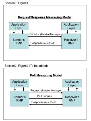
Strategy : Coordination • Establish a Bay Area Modeling Forum that will • guide agencies and NGOs in the selection, use, and interpretation of models for describing sediment-water relationships in fluvial and tidal systems • improve communication and coordination of local modelers and stakeholders • reduce duplication of efforts • improve the overall quality of modeling products
Strategy : Bay & Margins Model • Develop a flexible grid model capable of implicitly allowing for the interaction of fine-scale processes occurring at the Bay Margins with the larger-scale processes of the Bay proper
Strategy : Bay & Margins Model • What is a flexible grid anyway? • An approach to allow increased resolution in areas of concern
Strategy : Bay & Margins Model Curvilinear Grid Delft3d grid from P. Barnard (USGS)
Strategy : Bay & Margins Model Unstructured Grid SUNTANS grid of Puget Sound
Strategy : Bay & Margins Model • Some Model Options • Multibox • + Good for hypothesis testing • - Limited spatial/temporal resolution • - Limited ability to calibrate/validate • - Limited sediment capabilites • 3D Commercial : Delft3D, Mike, TRIM, UnTRIM • - Licensing can be costly • + Set-up often less complex than open-source • + ‘Package Deal’ - includes pre- and post-processing software • + Technical support is available • - ‘Black Box’ • 3D Open-Source : ROMS, SUNTANS, … • + Freely available • +/- State-of-the-art • +/- Community Support • - Set-up can be challenging • +/- Time is largest expense
Strategy : Bay & Margins Model • What is SUNTANS? • Stanford Unstructured Nonhydrostatic Terrain-following Adaptive Navier-Stokes Simulator • ‘Next generation’ of coastal models • Co-developed in SF Bay by Stanford and UC Berkeley • Open-Source • Includes water, sediment, contaminant capabilities • Accounts for tidal wetting/drying • Ocean boundary condition can be driven by ROMS
Strategy : Local Watersheds • Develop models of key watersheds over the next three years with the goal of developing a regional model (or set of models) • Watersheds will be identified by SPLWG and Small Tributaries Strategy Team • These groups will provide project oversight as well.
Model Proposal • What: Development of a highly-resolved three-dimensional model of South Bay • Who: Mark Stacey (UCB), Rusty Holleman (UCB), Ed Gross (Consultant), John Oram (SFEI) • Why: Project would provide support for a UCB graduate student to continue development of South Bay model and would help insure that development is relevant to RMP objectives.
Model Proposal • Specifics: Aim is to develop flexible grid of South Bay with emphasis on 1 or 2 tributaries (e.g., Guadalupe) and a Bay margin site (e.g., San Leandro Bay). Model will be useful for answering questions related to flushing times and exchange processes (e.g., what is influence of margin on Bay?). • Budget:


![Prepare PMI-RMP Exam with Actual PMI-RMP Dumps [PDF]](https://cdn4.slideserve.com/7889778/slide1-dt.jpg)