Download
1 / 1
10 likes | 163 Vues
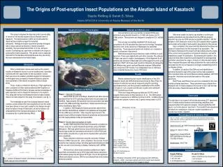
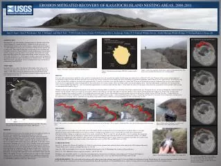
Gully Erosion: ~100,000 m 3. Wave Erosion: ~1,000,000 m 3. Coastal Erosion August 2008 – June 2009. EROSION MITIGATED RECOVERY OF KASATOCHI ISLAND NESTING AREAS, 2008-2011. DISSCUSSION As long as wave erosion remains the primary

E N D
Gully Erosion: ~100,000 m3 Wave Erosion: ~1,000,000 m3 Coastal ErosionAugust 2008 – June 2009 • EROSION MITIGATED RECOVERY OF KASATOCHI ISLAND NESTING AREAS, 2008-2011 • DISSCUSSION • As long as wave erosion remains the primary • given the strong nest site fidelity generally exhibited by these two species (Sealy, 1975; Roby and Brink, 1986; Piatt et al., 1990; Jones, 1993). Despite the extreme change in habitat at the primary colony site, both Crested and Least Auklets exhibited typical behaviors, e.g. courtship and copulation. Approximate extent of 2008 pyroclastic deposits (Photo courtesy of Burke Mees, Sept. 8, 2011) Gary S. Drew1, Chris F. Waythomas1, Jeff F. Williams2, and John F. Piatt1, 1 USGS Alaska Science Center, 4210 University Drive, Anchorage, Alaska, 2U.S. Fish and Wildlife Service , Alaska Maritime Wildlife Refuge, 95 Sterling Highway, Homer AK Fig. 3. Erosion by wave action here has regressed the coastline 300-400 m in less than one year. Pre-eruption Nesting Areas1996-2008 INTRODUCTION The magnitude, type, and sometimes-prolonged nature of volcanic activity in the Aleutian Islands have shaped the habitats and behavior of the species that use them. Kasatochi volcano, in the Central Aleutians, erupted explosively on August 7–8, 2008 completely burying all terrestrial habitats with pyroclastic deposits tens of meters thick. These deposits filled and covered rocky crevices in boulder and talus fields used by the estimated 500,000 seabirds, predominantly Crested Auklets (Aethiacristatella) and Least Auklets (Aethiapusilla), that nested on the island prior to the 2008 eruption. The strong colony fidelity of these two species (Sealy 1975, Jones 1993, Drew et al. 2010) suggests that these species must be adapted to the periodic disturbance regimes that dominate the Aleutian Islands. We examined the role of erosion as the primary recovery mechanism for crevice nesting species on Kasatochi Island 2009-2011. • STUDY AREA • Kasatochi Volcano, a small, 3 km diameter, 300 m high, island volcano in the central Aleutian Islands of Alaska (52.17° N, 175.51° W,) erupted violently on August 7, 2008. The resulting ash and pyroclastic flows blanketed the island, covering terrestrial habitats in 15-20 meters of material and increasing the size of the island substantially (Fig. 1). Figure 2. Time-lapse cameras installed above Tundering Cove. Figure 4. Gullies have expanded with the deepest gullys reaching approximately 30 m deep, but have provide little or no new access to nesting habitat. . Figure 3. Depiction of coastal changes 2008-2011, based on satellite imagery. 2009 • RESULTS • Wave and gully erosion began to modify the surface mantle of volcanic deposits relatively soon after the eruption. Satellite image data indicate that as of March 9, 2011 about 70 percent of the volcanic material emplaced beyond the pre-eruption coastline has been removed by wave erosion. The average erosion rate on the northern part of the island during the period from September 2008 to March 2011 was approximately 130-150 m/year (Fig. 3). Gully erosion further upslope has also progressed significantly (Fig. 4); however, in the three years since the eruption we estimate only 25 percent of the material covering pre-eruption nesting areas have been removed. Gully erosion was approximately an order of magnitude less than erosion due to wave action, and may slow as the deeper gullies reach the pre-eruption surface. Time-lapse photography in Tundering Cove documented the retreat of the beach bluff. The bluff 20 m - 30 m tall eroded back approximately 15 m between 2010 and 2011 (Fig. 5). On the North side of the cove the images clearly show the accumulation of beach boulders where nesting was identified in 2010 and 2011(Fig. 6). • Walking reconnaissance and indicated that the majority of the newly exposed nesting habitat is generally lower on the slope than the pre-eruption colony sites. The pattern of wave erosion and slumping has resulted in layers of boulders near the shoreline, where wave action can clear crevices. However, this exposure to weather and is likely to make these habitats of lower quality than the upslope pre eruption sites. We base this assertion on the numerous abandoned eggs in relatively simple 1-2 layer bolder piles in the spray zone. We were able to identify increasing nesting habitat of Crested and Least Auklets between 2009 and 2011 (Fig. 7). Some habitat was ephemeral, but coastal areas in Tundering Cove and the Northern shore have expanded each year (Fig. 7) and successful hatching in 2011 (Fig. 8). Despite the limited quantity and quality of the nesting habitat, nesting success has gradually increased along with the availability of nesting habitat, from complete failure in 2009 to an estimated hundred(s) in 2010, and thousand(s) in 2011. Whiskey Cove Tundering Cove Figure 1. Location of Kasatochi, Ulak and Koniuji Islands, Alaska. The volcano lies approximately 1900 km west of Anchorage in the western Aleutians. Red lines represent the at-sea survey tracks for seabirds during July of 1996 and 2003, and June of 2009. Time-lapse Camera 2010 ˆ Figure 6. Bolder pile in Tundering Cove where Least auklet nestlings were found in August 2011. Figure 5. Time sequence of shoreline erosion and beach bolder build-up on the north-west side of Kasatochi . The pre-eruption “Tundering Talus” colony site is further upslope outside the image frame.. Figure 7. Base of a gully on the South side of Kasatochi June 2011. The deepest gullys are approximately 30 m deep. • Fig. 1. Landsat image of Kasatochi Island collected 18 April 2009. The yellow line represents the shoreline prior to the 7 August 2008 eruption. June 2010 DISCUSSION The large amount of material deposited on Kasatochi by the 2008 eruption effectively eliminated all crevice nesting habitat on the Island. However, the rapid removal of volcanic material allowed both Crested and Least Auklets to attempt nesting within two years. Crested and Least Auklets have demonstrated a behavioral flexibility, making use of ephemeral and often low quality nesting habitat. While we expect the upward reproductive trend to continue, this exponential rate of increase is likely to level off. Although we estimate that that the number of fledged birds reached between one to several thousand(s) in 2011, it is unlikely that this level of reproduction will be sufficient to offset mortality of the breeding population that has had no significant recruitment since 2008. At-sea surveys will be conducted in 2012 to identify any changes in density based on previous surveys in 1996, 2003 and 2009 (Drew et al. 2010). Figure 6. One location of nesting habitat identified August 2011. Most pre-eruption nesting occurred approximately 100 m upslope, to the right. • METHODS • We examined the role erosion on the reproduction of Crested and Least Auklets on Kasatochi with a combination of geomorphologic analysis and field reconnaissance. Changes in the configuration of the post-eruption Kasatochi coastline were determined from study of satellite images obtained on September 17, 2008 and March 9, 2011, and are compared to the pre-eruption coastline as shown in an April 9, 2004 satellite image using a GIS model. A time-lapse camera was set up in “Tundering Cove” in 2010 (Fig. 2). Monthly images were examined to assess the recession of the bluff above the beach and document the buildup of beach boulders that can be used as nesting habitat by auklets. Field reconnaissance of nesting habitat was conducted in June and August of 2009-2011. Coastal areas were walked with the exception of “Whiskey Cove”, which contains a Stellar Sea lion rookery. It was logistically impossible to access most habitats higher up on the slopes of the volcano. For areas we could not access we relied on visual estimation from the coast. In all areas where we found both talus and the persistent presence of auklets there were signs of attempted nesting. Therefore we felt confident that we could identify significant nesting areas from the coast. 2011 ˆ LITERATURE CITED Drew, G. S., Dragoo, D. E., Renner, M., and Piatt, J. F., 2010. At sea observations of marine birds and their habitats before and after the 2008 eruption of Kasatochi Volcano, Alaska. Arctic, Antarctic, and Alpine Research, 42: 325–334 Jones, I. L., 1993: Crested auklet (Aethia cristatella). The Birds of North America, No. 70. Philadelphia: The Academy of Natural Sciences. Sealy, S. G., 1975. Influence of snow on egg-laying in auklets. Auk, 92: 528–538. Waythomas, C.F., Scott, W.E., and Nye, C.J., 2010, The geomorphology of an Aleutian volcano following a major eruption: the 7-8 August 2008 eruption of Kasatochi Volcano, Alaska, and its aftermath: Arctic, Antarctic, and Alpine Research, v. 42, n. 3, p. 260-275, doi:10.1657/1938-4246-42.3.260. December 2010 15 m Figure 8. Least auklet nestling in Tundering Cove, August 2011. Fig. 7. Available nesting habitat sequence from pre-eruption through 2011. The background image was collected in April 2009. The yellow line represents the pre-eruption coastline. The areas in red represent nesting areas . ACKNOWLEDGMENTS - This work would not have been possible without the past and continuing support of the U.S. Fish and Wildlife Alaska Maritime National Wildlife Refuge. We especially thank Vernon Byrd, and the crew of the M/VTîglax for their commitment to this work. We thank the North Pacific Research Board, U.S. Fish and Wildlife Service and U.S. Geological Survey for providing funding for the post-eruption research. June2011