Download
1 / 17
170 likes | 289 Vues
This study details the systematic comparison of global DRAKKAR simulations (G70) with various observational data, including temperature and salinity profiles. Conducted during the 2009 Drakkar meeting in Grenoble, France, it assesses the accuracy and observability of ocean dynamics, exploring the impacts of model resolution, numerical schemes, and parameterizations. It implements quadrilinear collocation for statistical analysis and investigates sampling errors across different regions and times, particularly focusing on mixed layer depths and hydrographic quantities from 1998 to 2004.

E N D
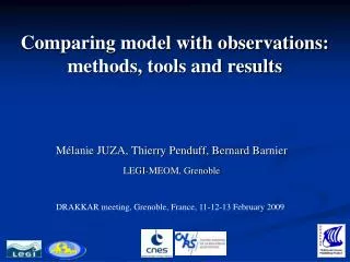
Comparing model with observations:methods, tools and results Mélanie JUZA, Thierry Penduff, Bernard Barnier LEGI-MEOM, Grenoble DRAKKAR meeting, Grenoble, France, 11-12-13 February 2009
Objectives / Activities Global Drakkar simulations: G70 (DFS3 forcing): ¼°, ½°, 1°, 2° • Observations: T/S profiles (ENACT-ENSEMBLES), SLA (AVISO), SST (Reynolds) • Assessment of DRAKKAR simulations • - Quantitative and systematic comparisons model/observations • - Intercomparison of simulations • (impact of resolution, forcing, numerical scheme, parametrizations) • Observability of the ocean dynamics (OSSE) • - Accuracy of ARGO array • Distribution of data and tools to the scientific community • Development of tools: collocation model/observations, statistics, vizualization • Scientific studies. Papers in preparation…
Hydrography: collocation ENACT/ENSEMBLES (ARGO, XBT, CTD, buoys) T,S(x,y,z,t) profiles (~8.106) Global. 1956-2006 MODEL T,S(x,y,z,t) Global. 1958-2007 • Keep good data only • Quadrilinear collocation (obs. space) SAMPLING ERROR VALIDATION COLLOCATED OBSERVED and MODEL T,S(x,y,z,t) profiles Dispersed in time and space Temporal, spatial, vertical (mixed layer) integrations Statistical analysis
Hydrography: collocation ENACT/ENSEMBLES (ARGO, XBT, CTD, buoys) T,S(x,y,z,t) profiles (~8.106) Global. 1956-2006 MODEL T,S(x,y,z,t) Global. 1958-2007 • Keep good data only • Quadrilinear collocation (obs. space) SAMPLING ERROR VALIDATION COLLOCATED OBSERVED and MODEL T,S(x,y,z,t) profiles Dispersed in time and space Temporal, spatial, vertical (mixed layer) integrations Statistical analysis ARGO 1998-2004
Hydrography: simulated and observed MLD August 1998-2004 February 1998-2004 Mixed layer depths (MLD) (m) ARGO ORCA025-G70 Realism of simulated and observed MLD
Hydrography: method for the analysis of mixed layer quantities 83% Median 17% • Distribution of Mixed Layer Depth / Temperature / Salinity / Heat and Salt Contents • Medians and percentiles 17% and 83% Exemple: MLD in North Atlantic September 1998-2004 SAMPLING ERROR MODEL BIAS -- full model -- subsampled model (like ARGO) -- ARGO
Hydrography: sampling errors Monthly cycles of MLD (1998-2004): zone MNW-ATL -- subsampled model (ARGO) -- full model MLD Solid lines = medians Dashed lines = percentiles 17%, 83% Sampling error well observed monthly cycle. Sampling error in winter.
Hydrography: sampling errors at global scale MLD too shallow too deep ARGO sampling errors on the monthly MLD (1998-2004) Sampling error = <subsampled model > – <full model> Bins = 30° x 30° x 1 month (1998-2004) • ARGO sampling errors maximum in winter (extreme values ~100m) • Especially in inhomogene (Southern Ocean, North Atl.) and coastal regions
Hydrography: sampling errors at global scale MLD too shallow too deep ARGO sampling errors on the monthly MLD (1998-2004) Sampling error = <subsampled model > – <full model> Bins = 30° x 30° x 1 month (1998-2004) • ARGO sampling errors maximum in winter (extreme values ~100m) • Especially in inhomogene (Southern Ocean, North Atl.) and coastal regions
Hydrography: sampling errors at global scale MLD too shallow too deep ARGO sampling errors on the monthly MLD (1998-2004) Sampling error = <subsampled model > – <full model> Bins = 30° x 30° x 1 month (1998-2004) • ARGO sampling errors maximum in winter (extreme values ~100m) • Especially in high variable (Southern Ocean, North Atl.) and coastal regions
Hydrography: sampling errors at global scale MLD too shallow too deep ARGO sampling errors on the monthly MLD (1998-2004) Sampling error = <subsampled model > – <full model> Bins = 30° x 30° x 1 month (1998-2004) • ARGO sampling errors maximum in winter (extreme values ~100m) • Especially in high variable (Southern Ocean, North Atl.) and coastal regions
Hydrography: conclusion • Assessment of ARGO sampling errors • - More dependence on spatial distribution of floats rather than number of floats • - MLT, MLS, MLHC, MLSC • Assessment of the simulations • - Mixed layer monthly cycles • - Impact of resolution • Perspectives • Extension to: - recent years (maximum ARGO coverage) • - the last 50 years (interannual cycles) • - all instruments (ARGO floats + CTD, XBT, moored buoys…)
Altimetry: collocation AVISO altimeter SLA(x,y,t) database Quasiglobal. 1993-2004 MODEL SSH(x,y,t) Global. 1958-2007 Quantitative Assessment Variances, Correlations, EOFs, etc FILTERED MODEL and AVISO SLA(x,y,t) 1993-2004 • Trilinear collocation on 1/3°x1/3°x7day AVISO Maps • Mask AVISO under MODEL Ice • Mask MODEL under AVISO Ice • Linear detrending • Remove 1993-1999 means • Remove spatial averages Space-Time Lanczos Filtering Annual Hi-freq Inter annual Space COLLOCATED MODEL and AVISO SLA(x,y,t) Large- scale 6° Regional & mesoscale 18 months 5 months Time
Altimetry: interannual SLA (statistics) SLA standard deviation Model/obs SLA correlation => Forced vs intrinsic variability in the Southern Ocean Impact of resolution on low-frequency variability SLA standard deviation (cm) (1993-2004) AVISO ¼°: ORCA025-G70 ½°: ORCA05-G70.113 1°: ORCA1-R70 2°: ORCA246-G70 Global increase of interannual variability with resolution Interannual variability increases in eddy-active regions Correlation decreases with resolution in S.O.
Altimetry: interannual variability (EOFS) Assess the ability of models to reproduce the observed interannual variability in various regions • Data processing • - Observed SLA EOFs (decomposition: spatial mode + temporal amplitude-PC) • Projection of simulated SLA on observed SLA EOFS • Comparison PC(obs)/projections: % variance, correlation Exemple: interannual SLA in North Atlantic (1993-2004) Mode 1 – Observed SLA – %var=17 Associated obs. amplitude and mod. projections Lag with NAO (weeks) obs¼° ½° 1° 2° Projections of simulated SLA reproduce main features of the obs. variability. More explained variance with 1/4° Simulated lags more realistic with increase of resolution Intergyre gyre of Marshall Resolution improves space-time variability
Altimetry: interannual variability (EOFS) Exemple: large-scale (>6°) and interannual SLA in Southern Ocean (1993-2004) Mode 1 – Observed SLA – %var=18 Associated obs. amplitude and mod. projections Response to ENSO Resolution does not change variance projected on observations Conclusion: - Global and regional (North Atl., Gulf Stream, Equat. Pac., Indian, Southern Ocean) - Resolution improves space-time variability, except in Southern Ocean (intrinsic variability?) - Similar processing applied to SST analysis (Reynolds, NCEP) - Response of ocean to atmospheric variability (NAO, ENSO, SAM, AAO…) - Impact of mesoscale on low-frequency variability
Conclusion • Collocate and compare model & observations: T, S, SLA, SST • Assess simulations. Quantify model sensitivities • Evaluate the accuracy of observing systems (ARGO sampling errors, paper in preparation) • Tools are mature. Technical report & users manual. Fields are being distributed. • Perspectives • Further assess the interannual variability in eddying models (paper in preparation) • Evaluate every new simulation (global, regional, reanalyses) • Extend to new datasets: current meters (G. Holloway), ice field thickness (A. Worby), • gravimetry, maregraph, SSS, … • Foster collaborations http://www-meom.hmg.inpg.fr/Web/pages-perso/MelanieJuza/