Download
1 / 19
190 likes | 305 Vues
Explore soils and geology characteristics for land use planning in Kentucky. Identify site characteristics, local issues, view groundwater flow maps, access soils reports, and create custom site maps. Discover wastewater treatment and public water infrastructure information. Use GIS tools and resources for site analysis.

E N D
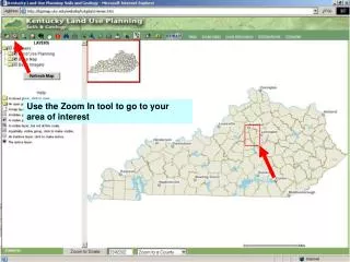
Land Use Planning: Soils and Geology Use the Zoom In tool to go to your area of interest
IDENTIFY SITE CHARACTERISTICS The Point Locate tool will provide the coordinates of your point. Popup blockers must be off. X
SOILS AND GEOLOGIC CHARACTERISTICS The Identify all tool will tell you the site characteristics for all the layers showing at that point. Again, popup blockers must be off. X
LOCAL ISSUES Clicking on the KYGEONET field in the counties table will link you to a variety of information about the county.
SOILS REPORTS Soils reports from the Soil Survey with expanded discussion of soils limitations for various activities
LOCAL ISSUES -- KARST LINKS TO MORE INFORMATION Pictures and diagrams discussing local issues, such as sinkhole flooding
GROUNDWATER FLOW MAPPING X Groundwater flow maps shows how water may flow underground in karst areas and reemerge miles away in a spring
GROUNDWATER IN THE COUNTY Groundwater Reports for each county describe geology and availability of water resources
SITE MAPS X You can create a variety of site maps. Set scale and turn layers off and on to create Soils, Geology, Topography, and Aerial Photo maps by right clicking and saving as jpg images.
GEOLOGY SOILS X X TOPOGRAPHY AERIAL PHOTO X X Saved as jpg files, the various site maps may then be inserted into documents and reports.
LINKING TO OTHER INTERNET MAPS In this example, an investigation of the geology revealed severe limitations for a conventional on-site septic system. The KYMAPS tool links to a variety of online maps at the same point. X
KENTUCKY INTERNET MAP ATLAS In this case we want to link the the internet map showing the availability of public sewer in our area
WASTEWATER TREATMENT INFRASTRUCTURE X Using the measure tool on the wastewater treatment map shows that a Versailles Municipal Wastewater sewer line extension of 1.62 miles would reach our lot, and 2.02 miles would serve the entire road.
PUBLIC WATER INFRASTRUCTURE The public water internet map shows that our area is already served by the Northeast Woodford Water District
BENCHMARK DATA X Benchmark data for surveys are available from the internet Commonwealth Map
BOOKMARK PROJECT AREA X The Bookmark tool will create a url allowing you to return to the same area later.
Additional planning information is available at kgsweb.uky.edu/download/misc/landuse/mainkyluplan.htm
Coal Water Fuels Data Gas GIS Oil Maps INTERNET GIS TOOLS FOR SITE ANALYSIS IN KENTUCKY Dan Carey -- carey@uky.edu Welcome Kentucky Geological Survey The University of Kentucky “Earth Resources—Our Common Wealth”