ZMA 11-01
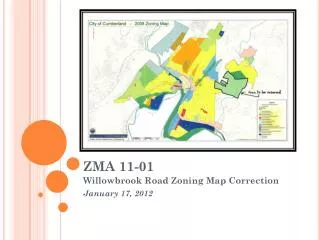
ZMA 11-01. Willowbrook Road Zoning Map Correction January 17, 2012. Background:. Staff discovered a conflict in the on-line Zoning Map labels for the Willowbrook Road R-O Zone on August 2, 2011 Errant label identifies the area as zoned B-H, when the approved zoning is R-O

ZMA 11-01
E N D
Presentation Transcript
ZMA 11-01 Willowbrook Road Zoning Map Correction January 17, 2012
Background: • Staff discovered a conflict in the on-line Zoning Map labels for the Willowbrook Road R-O Zone on August 2, 2011 • Errant label identifies the area as zoned B-H, when the approved zoning is R-O • The error was traced to a commuter data base labeling glitch that occurred when the maps were updated between 2008 and 2011. • The error affects 24 lots of record along Willowbrook & Old Willowbrook Roads, encompassing, among others: • Western Maryland Hospital • Allegany College • Allegany County Health Department Complex • Cumberland Meadows • Since MD Law does not provide for technical map corrections, a formal rezoning of the property was deemed necessary to correct the Zoning Map • The Planning Commission conducted a public hearing on this petition on October 17, 2011 and recommends approval
Mistake Determination: • Staff researched the annexations for all properties to determine original zoning designations • Willowbrook Road Annexation – June 13, 1997 – Zoned R-O • Mitchell Property Annexation – August 1, 2003 – Zoned R-O • Staff researched the 2008 Comprehensive Rezoning to confirm that no change to the original zoning was contemplated • Staff determined that the labeling error occurred between the first zoning of the official map in 2008 and an updated version of the same map in 2011 • No rezoning petition for any of the affected properties was filed during that period • The color coding of the affected zone on all zoning maps (both before and after the error occurred) depicts the area as zoned R-O • Only the label on the 2011 map identifies the area as zoned B-H
Staff Findings & Recommendation: • The need for the rezoning action was caused by a computer error in the Official Zoning Map • No action was taken by the City to zone the affected areas B-H • No petitions for rezoning of the affected properties have been filed • The requested rezoning will not affect any uses currently built on the affected properties • The proposed rezoning is consistent with the City’s Comprehensive Plan and the original zoning of the area at annexation • Staff recommends approval of the proposed rezoning