Download
1 / 3
30 likes | 147 Vues
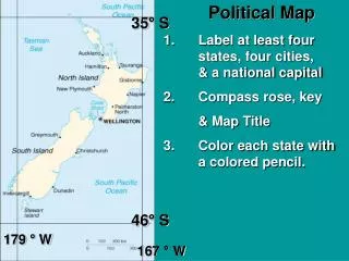
Learn how to create a detailed political map by labeling at least four states, four cities, and a national capital. Include essential elements such as a compass rose and a map key. For the physical map, mark ten physical features like mountains, rivers, and lakes, ensuring to calculate land area as needed. Use colored pencils to bring your map to life while following the provided guidelines and examples. Perfect for enhancing your geography skills, this project will help you understand both political and physical landscapes.

E N D
Political Map 35° S • 1. Label at least four states, four cities, & a national capital • Compass rose, key • & Map Title • 3. Color each state with a colored pencil. 46° S 179 ° W 167 ° W
125 ° w Sample Political Map 100 ° W N W E S 15 ° S Maple Bar ▪ Syrup City ◙ Duncan Chocolate ▪Cocoville Glazed ▪Sugar city Cream Filled See pg RA 18-19 for a sample of a political map ▪Custard Town Key ▪ = City ◙ = Capital 25 ° S
Physical Map • Label at least 10 physical features on your island such as mountains, rivers, lakes, deserts, oceans, bays, etc. • See pg RA 36-37 for other physical features • Calc. land Area A=H X W (See your samples) Physical Map