Download
1 / 55
680 likes | 1.17k Vues
Mesozoic Geology. Introduction. The Mesozoic began 248 mya and ended 65 mya Three periods - Triassic, Jurassic, Cretaceous breakup of Pangaea was the major geologic event tectonism and sedimentation are used to classify the Mesozoic in N. America

E N D
Introduction • The Mesozoic began 248 mya and ended 65 mya • Three periods - Triassic, Jurassic, Cretaceous • breakup of Pangaea was the major geologic event • tectonism and sedimentation are used to classify the Mesozoic in N. America • Note the overlap in three styles of Cordilleran Orogeny
Tectonism and Sedimentation Seaway drains
1. The Breakup of Pangaea • The movement of continents during and after the breakup affected global climates • Sea-level changes due MOR heating and growth, then cooling
Pangaea - Early Triassic Pangaea ran from pole to pole and straddled the equator. The Panthalassa Ocean allowed equatorial waters to warm polar lands. The East coast indent is called the “Tethys Sea” Tethys Panthalassa Panthalassa
Late Triassic – Rifting E Orogeny W We will consider mostly North America for this lecture Orogeny Rift Better look at Tethys
E Jurassic – Atlantic Rift Shallow Note offshore Terranes
E Jurassic – Another Look Orogeny New Sea Wrangellia
Latest Jurassic – Early Cretaceous Atlantic Connected with Tethys Africa rotation closes Tethys
Tethys Atlantic
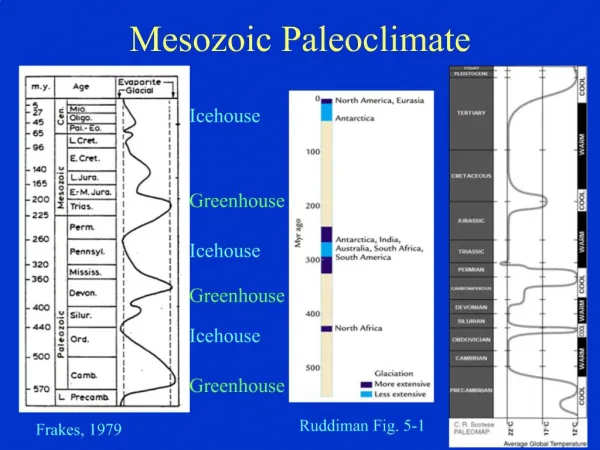
Mesozoic Global Climates • Carbonates (for example the stable isotope ratio d13C)reveal large concentrations of carbon dioxide present in the Mesozoic atmosphere. • This suggests a greenhouse climate. • No glaciers, no coal, so CO2 abundant. • Greenhouse gasses pass sunlight which hits the land and sea. Re-radiate heat (IR) • Greenhouse gasses hold the heat, not lost to space as quickly. Warmer equilibrium.
Global Climates in the Mesozoic • Mesozoic climates were more equable than today, lacked the strong north-south climate zones. • Mesozoic plant fossils indicate subtropical conditions in high latitude locations • Seasonal differences were monsoonal Cycads
Next: Mesozoic Tectonics NA • Cretaceous : global rise in sea level until 75 -70 mya, vast MOR • Jurassic: • Atlantic opens E, • began building the Cordillera W, • Gulf of Mexico begins to form and experiences evaporite deposition • Late Triassic: Begin rifting in East Start here
Late Triassic: Rifting opens the Atlantic • The Newark Supergroup documents the rifting of Pangaea to form the Atlantic • Early Triassic saw coarse detrital sediments deposited from the erosion of Appalachian highlands • fault-block basins developed as N. America separated from Africa and filled with nonmarine sediment plus dikes and sills • eroded to a flat plain by the Cretaceous
Mesozoic rift basins Kean University
Structure of the Newark basin Note how faulting offsets sedimentation
Lake cycles, East Berlin formation Alternating wet and dry climate due 21000y Milankovitch cycle of tilt axis wobble Also 100,000 year cycles due to orbit eccentricity
E. Jurassic Gulf Coast Evaporites 200 mya is just outside our door Restricted Basin Lots of evaporation
Gulf Coastal Region • First, as continents separate, restricted basin, thick evaporites formed in the Gulf • Normal marine deposition returned to the Gulf by Late Jurassic, with transgressions and regressions • thousand of meters of sediments were deposited Does this cross-section show a transgression or regression?
Gulf Coast continental margin Rising Salt Domes tilt sediments Concentrate petroleum
Discussion: Petroleum exploration around salt domes Squint: The Petroleum is in the bright spots, at the boundary of the salt and pushed up sediment. Tells us where to look, saves money, lowers cost of fuel.
Next: Western North AmericaTectonics • Building the western margin of North America and the Cordillera
Displaced terranes – Western Cordillera These terranes overlap in age but have different rock types, paleolatitudes and fossils. However, we can deduce when they accreted from this map. Exercise: Arrange the following terranes by oldest to youngest time of accretion onto the west coast: Alexander,Cache Creek, Chugach,Eastern, Stikine, Taku, Tracy Arm,Wrangellia, Yukon-Takana
Western Region • Cordilleran Orogeny • Laramide – Vertical blocks-built the present day Rockies K-Tertiary • Sevier – J-K thrust faulting to the east • Nevadan - Jurassic batholith intrusion in the Sierra Nevada and elsewhere on the western edge
Western Margin during Orogens North America drifting west due opening of Atlantic Westward subduction zones stopped when continental crust arrived. Late Triassic on, eastward subduction of Farallon oceanic crust continues Cordilleran Orogeny Late J Early K Nevadan Batholiths Remember the late Permian Sonoma? It continued into the Early Triassic Nevadan Orogeny east subduction Farallon Sonomia docking Late Pm –Early Triassic
Sierra Nevada Mountains Nevadan Orogeny: Subduction formed batholith cores of continental volcanic arc once as tall as Andes
Mesozoic orogenic events Thin-skinned tectonics K-T Laramide Continental Overide Bouyant Subduction Cretaceous Sevier Wrangellia docking? Later moved by transform fault?
Buoyant Subduction Laramide Orogeny Vertical block uplift Normal, thin-skinned Now we understand weird looking Tetons Approaching Continent pushes accretionary wedge sediments into forearc sediments
Sevier thin-skinned deformation Using the layer colored sky blue, look at the faults. Is the hanging wall mostly up or down? What kind of faults are these?
Sevier thrust belt Precambrian and/or Paleozoic Sediments thrust over younger Mesozoic rocks
Look in detail at western plate margin This area has much simpler geology Franciscan Range, Great Valley Group, and Sierra Nevada Volcanics and Plutonics
Next: Mesozoic Sedimentation on the Craton • Cretaceous • extensive marine deposition until 70mya, thins to the east • Jurassic • clean cross-bedded sandstones • marine sediments in the Sundance Sea • Triassic • shallow-water marine clastics • red beds Foreland Basin!
North America - Triassic Marine deposition limited to western margin Volcanic Arc sends frequent ashfalls eastward Newark Pollen similar Chinle Note Equator
Late Triassic Chinle Fm. Mudstones and Sandstones of stream deposits, volcanic ash, with fossil trees (the Petrified Forest!) Texas, New Mexico, northern Arizona, Nevada, Utah, and western Colorado Pollen studies show that the Chinle is the same age as early Newark Supergroup http://en.wikipedia.org/wiki/Petrified_Forest_National_Park
Triassic caliche paleosol- Nova Sc. Source of carbonates for d13C measurements. Results suggest high CO2 in atmosphere Similar in Newark Supergroup
North America - Jurassic period Dry region in the rain shadow of the beginning Nevadans Zuni Transgression
Sedimentation Seaway drains Evaporites
Jurassic Eolian sandstone Navaho SS, S. Utah
http://rainbow.ldgo.columbia.edu/courses/v1001/morisson14.htmlhttp://rainbow.ldgo.columbia.edu/courses/v1001/morisson14.html Jurassic Morrison Formation Paul Olsen's Dinosaur Course Stream Deposits, huge sauropods Apatosaurus, also Stegosaurus, carnivore Allosaurus
Fossils of Jurassic dinosaurs Morrison Formation sandstones, DNM, Vernal, Utah
Giant sauropod and Allosaurus bones, Mossison Fm., DNM, Vernal Utah
Late Cretaceous really big epeiric sea Dinosaurs on the North Slope Until 70 mya Land Land
Did the Sevier Orogenic Belt form before or after the Navaho SS, lower left? Did the Sevier Orogenic Belt form before or after the Fox Hills SS, upper right? Fox Hills SS Western Interior Seaway Regression Western Interior Seaway Transgression Navaho SS Dakota SS is bottom right
Dakota Sandstone Early Cretaceous shallow sea sediments gently folded by Sevier Orogeny.