Download
1 / 20
200 likes | 374 Vues
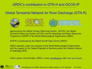
Global Terrestrial Network for River Discharge (GTN-R). sponsored by the Global Climate Observing System (GCOS), the Global Terrestrial Observing System (GTOS) and the Hydrology and Water Resources Programme (HWRP) of the World Meteorological Organization (WMO)

E N D
Global Terrestrial Network for River Discharge (GTN-R) sponsored by the Global Climate Observing System (GCOS), the Global Terrestrial Observing System (GTOS) and the Hydrology and Water Resources Programme (HWRP) of the World Meteorological Organization (WMO) GTN-R is conducted by the Global Runoff Data Centre (GRDC) GRDC operates under the auspices of the World Meteorological Organization with the support of the Federal Republic of Germany within the Federal Institute of Hydrology (BfG) Ulrich Looser, Irina Dornblut, GRDC, e-mail: grdc@bafg.de, web: http://grdc.bafg.de 8th Meeting of the GRDC Steering Committee, Koblenz, 19-21 Sep 2007
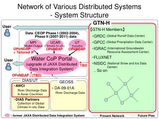
Global Terrestrial Network for River Discharge (GTN-R) • Background information to the project realisation since 2005 • Status and next steps • Action Item T4 of GCOS-IP Designation of the GCOS Baseline River Discharge Network • GTN-H project 1.3 Definition of an ISO 19115/19139-conform metadata profile and a web-based infrastructure for the metadata management • GTN-H project 2.2 Development of the GRDC NRT Monitor as a pilot web application for retrieval, integration and presentation of real-time hydrologic data 8th Meeting of the GRDC Steering Committee, Koblenz, 19-21 Sep 2007
Background information to GTN-R realisation 2. NOKIS/NOKIS++ (http://nokis.baw.de/) • information infrastructure for the North and Baltic Sea Coast as contribution to an Integrated Coastal Zone Management (German) • brings together the metadata of several institutions to a „network of metadata“, hurdling their sectoral views by the joint use of a standardised web-based environment and metadata profiles conform to ISO 19115 • BfG (GRDC‘s hosting institution) is one of currently 16 German federal or state authorities who participate in the project • benefit is expected from new developments regarding the standardised metadata collection, processing and management • ISO 19115-conform profiles for geo-data, time series, measurements, ... • web-based environment for metadata collection, processing and management developed and commercially distributed by a German software company 8th Meeting of the GRDC Steering Committee, Koblenz, 19-21 Sep 2007
Background information to GTN-R realisation 3. European Terrestrial Network for River Discharge – ETN-R (http://etn-r.bafg.de) – under development (2006-2008) • service for the automated near real-time data collection of river gauging data as contribution to the European Flood Alert System (EFAS) of the EC-JRC • metadata about the data providers, stations and the data transfer schemes • real-time river discharge and water level data with a high temporal resolution • historic data as long time series to check the plausibility of the NRT data • synergies are expected by the use of • valid contact information and reliable station selection for European countries • software system for the automated transfer of real-time data, their harmonisation and processing • mapping application to display actual and forecasted river discharges in relation to long-term thresholds 8th Meeting of the GRDC Steering Committee, Koblenz, 19-21 Sep 2007
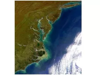
European Terrestrial Network for River Discharge (ETN-R) Synergies between both projects are evident, but limited due to the different focus: • GTN-R focuses on the outlet stations • ETN‑R focuses on the complete river basins 18 of the 36 countries contacted within the ETN-R project are of interest to the GTN-R River basins covered by the GTN-R (red outlined) and the ETN-R (blue coloured) 8th Meeting of the GRDC Steering Committee, Koblenz, 19-21 Sep 2007
A. GCOS Baseline River Discharge Network (GCOS-IP T4: Establishment of the GTN-R) Objective “Confirm locations of GTN-R sites, determine operational status of gauges at all GTN-R sites, ensure that the GRDC receives daily river discharge data from all 380 sites within one year of their observation.” Output/deliverable • Identification and establishment of reliable contacts to the NHS • Identification of gauging stations suitable to capture the global freshwater flux to the oceans and their operational status • Designation of the GCOS Baseline River Discharge Network • Initial reporting of historical records of the confirmed reference stations • Submission of daily discharge data of confirmed stations within one year of their observation 8th Meeting of the GRDC Steering Committee, Koblenz, 19-21 Sep 2007
A. GCOS Baseline River Discharge Network (GCOS-IP T4: Establishment of the GTN-R) Progress to date: 2004: Initial selection of 380 gauging stations by the GRDC (finished) 2005: Support letter signed by the WMO Secretary General to identified contacts (PR and HA of 82 countries) 2006: Response to the support letter from 21 countries (25%), no general denial was communicated Initial provision of historical river discharge data (in process, until now by the NHS of 10 countries) Start of the regular transfer of real-time data (in process, 3 countries) Definition of the Development of the GRDC NRT data exchange format (finished within the ETN-R project) 2007: Confirmation of reference stations (in process, currently 185 gauging stations in 20 countries) 8th Meeting of the GRDC Steering Committee, Koblenz, 19-21 Sep 2007
A. GCOS Baseline River Discharge Network (GCOS-IP T4: Establishment of the GTN-R) 8th Meeting of the GRDC Steering Committee, Koblenz, 19-21 Sep 2007
A. GCOS Baseline River Discharge Network (GCOS-IP T4: Establishment of the GTN-R) To-Do Evaluation of known contacts to the NHS, identificationof new contacts using • publicly available information (e.g. publications and websites of the NHS or other national bodies in charge of operational hydrology) • provider information of the ETN-R project (for Europe) Confirmation of the 265 remaining, initially proposed stations in 62 countries based on • newly established provider contacts • publicly available inventories of hydrometric stations • station selection of the ETN-R project (for Europe) 8th Meeting of the GRDC Steering Committee, Koblenz, 19-21 Sep 2007
B. Demonstration of metadata (GTN-H project 1.3) Objective “... propose a standardised detailed metadata format for selected GTN-H data types and demonstrate their use in enabling the user to discover and access data and related information (e.g. data quality)”. Output/deliverable • Background knowledge: Report on metadata: Need and current practices(finished) • Metadata profile for GTN-H conform to ISO 19115 : GRDC proposal to describe the river discharge component in the WMO Core Metadata Profile (in process) • Provide infrastructure: Web-based ISO 19115/19119/19139 compatible metadata management application allowing the standardised metadata collection, processing and management by various data providers (still outstanding) • Filling of metadata infrastructure with real data (still outstanding) * WMO19115: WMO Core Metadata Profile (http://www.wmo.int/pages/prog/www/wisweb_newstyle/metadata/profiles_en.html) 8th Meeting of the GRDC Steering Committee, Koblenz, 19-21 Sep 2007
B.Definition of a ISO 19115 conform metadata profile Progress to date: 2005: Example of metadata set according to WMO 191151 2006: GRDC proposal to describe the river discharge component(as of summer 2006) considering element definitions of • WMO 19115 core metadata profile • CUAHSI2and HydroML3 • ISO 639 (language code list), ISO 3166 (country code list), ISO 4217 (currency code list) • ISO 8601 (date and time representations) • ISO 11404 (IT - Programming languages, ... Languageindependent datatypes) • ISO 19107 (GI - Spatial schema) • ISO 19108 (GI - Temporal schema) • ISO 19109 (GI - Rules for application schema, GeneralFeatureModel) • ISO 19111 (GI - Spatial referencing by coordinates) • ISO 19115 (GI - Metadata), • OGC OM 05-087r4 (OGC Best Practice Doc on Observations and Measurement) 2007: Metadata profiles for geo-data, time series, projects and services developed within the framework of the German NOKIS++4 project 1 WMO19115: WMO Core Metadata Profile 2 CUAHSI: Consortium of Universities for the Advancement of the Hydrologic Sciences (United States) 3 HydroML: Hydrologic Markup Language developed by NWIS of USGS and CUAHSI 4 NOKIS++: project which investigates the implementation of information infrastructures as part of the Integrated Coastal Zone Management 8th Meeting of the GRDC Steering Committee, Koblenz, 19-21 Sep 2007
B.Definition of a ISO 19115 conform metadata profile To-Do Discussion / revision of the proposed metadata profile considering the recent developments of other metadata profiles for hydrologic/hydrometric data (e.g. HydroML, NOKIS++, WMO 19115, ...) Translation of the GRDC metadata profile to XML (at present in XLS tables) Integration in WMO Core Metadata Profile 8th Meeting of the GRDC Steering Committee, Koblenz, 19-21 Sep 2007
8th Meeting of the GRDC Steering Committee, Koblenz, 19-21 Sep 2007
B.Web-based infrastructure for the metadata management Progress to date: 2005: Engagement in the German NOKIS++ , a project which investigates the implementation of information infrastructures as part of the Integrated Coastal Zone Managementfor the North and Baltic Sea 2006: No active participation in NOKIS++ by the GRDC Web-based environment for the standardised metadata collection, processing and management (originally developed for NOKIS++) became a stand-alone software product, commercially distributed Start of the ETN-R project at the GRDC (re-use of envisaged infrastructure for the metadata management intended at that time) 2007: Exclusion of the development of the metadata management tool from the ETN-R project no re-usable product internally available at time 8th Meeting of the GRDC Steering Committee, Koblenz, 19-21 Sep 2007
B.Web-based infrastructure for the metadata management GRDC proposes to • buy a completed software product which provides a web-based environment for the standardised metadata collection, processing and management, e.g. the web-based environment which was originally developed for NOKIS and today is commercially distributed by a German software company • customise this software productfor the special needs of the GTN-R (GTN-H) project and for future data management projects of GRDC • adjust to the WMO 19115 metadata profile Needs: • Funding (license fee/s and costs for the customisation of software and the adjustment to the WMO Core Metadata Profile) • Technical specification and supervision 8th Meeting of the GRDC Steering Committee, Koblenz, 19-21 Sep 2007
C. GRDC NRT Monitor (GTN-H project 2.2) Objective “Development of ... a pilot web application that demonstrates the retrieval, integration and presentation of real-time hydrometric data.” Output/deliverable • Development of standards for the near real-time transfer of river discharge observations taken by the NHS to the GRDC • Development of a software to collect real-time discharge data from distributed servers, check the plausibility of the data, harmonise them, and make them available in a standardised format • Map application to graphically display the stations of the GTN-R network in an interactive, scaleable map indicating the actual hydrologic situation • Data acquisition • Annually submission of daily dischargedata to the GRDC within one year of their observation • Regular submission of near real-time dischargedata to the GRDC with a one-day delay 8th Meeting of the GRDC Steering Committee, Koblenz, 19-21 Sep 2007
C. GRDC NRT Monitor Progress to date: 2004: First prototype of an operative engine that continuously monitors online active data sources 2005: Prototype of a map application using the ArcReader software to display the stations of the initially proposed GTN-R network 2006: Definition of the version 3.0 of the GRDC NRT Data Format 2007: Development of a software system that draws together near real-time river water level and discharge data provided by individual NHS via Internet protocols, checks the plausibility of the data, harmonises them and re-distributes them in the GRDC NRT format to EC-JRC (under development within the ETN-R project) 8th Meeting of the GRDC Steering Committee, Koblenz, 19-21 Sep 2007
C. GRDC NRT Monitor To-Do Adaptation of the ETN-R software system to the data collecting and processing needs of the GTN-R Negotiation and establishment of data transfer procedures with the contributing National Hydrological Services or the national institutions in charge 8th Meeting of the GRDC Steering Committee, Koblenz, 19-21 Sep 2007
Global Terrestrial Network for River Discharge (GTN-R) • Designation of the GCOS Baseline River Discharge Network (Action Item T4 of GCOS-IP) • under revision, coordination with the HARON project needed • Definition of a ISO 19115 conform metadata profile and a web-based infrastructure for the metadata management • (GTN-H project 1.3) • in process (development of the metadata profile) funds needed (license fee/s, customisation of a software product) • Development of the GRDC NRT Monitor, a pilot web application that demonstrates the retrieval, integration and presentation of real-time hydrometric data (GTN-H project 2.2) • still outstanding, re-use of the ETN-R software system intended 8th Meeting of the GRDC Steering Committee, Koblenz, 19-21 Sep 2007
The Global Terrestrial Network for River Discharge (GTN-R): Real-time Access to River Discharge Data on a Global Scale. 1st Interim Report / U. Looser, I. Dornblut, T. de Couet. - Koblenz, 2007. - (GRDC Report 36) Thank you for your attention! Irina Dornblut, GRDC, BfG, e-mail: dornblut@bafg.de 8th Meeting of the GRDC Steering Committee, Koblenz, 19-21 Sep 2007