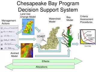
Chesapeake Inundation Prediction System Elements
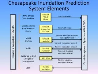
The Chesapeake Inundation Prediction System utilizes advanced forecasting elements to predict wind fields and major river discharges, focusing on the Middle Atlantic region. This system is crucial for assessing potential inundation events, particularly during nor’easters, such as those observed from November 10-13, 2009. It integrates data from NOAA, USGS, and other agencies to provide emergency management guidance and validate inundation forecasts. By visualizing and transmitting relevant data, stakeholders can make informed decisions to mitigate flood impacts.

Chesapeake Inundation Prediction System Elements
E N D
Presentation Transcript
Chesapeake Inundation Prediction System Elements Forecast Wind Fields Economic Evaluation - UMCES Data Management System – NOAA CBO NWS offices WeatherFlow Transmit forecast Forecast major river discharge Middle Atlantic River Forecast Center Transmit forecast Forecast inundation Retrieve wind field and river discharge forecasts VIMS UMCES Transmit inundation forecast Visualize inundation Retrieve inundation forecast Noblis Transmit visualized inundation forecast NWS WFO Guidance to brief Emergency Management Retrieve visualized inundation forecast Validate Inundation USGS
SewellsPt (Norfolk) Storm Tide – NOS CO-OPS Data Nov 10-13, 2009 Tue Wed Thu Fri Watch Issued Warning Issued Major Moderate Minor
Nor’easter – Norfolk VA Should I Have Moved My Car? VIMS ELCIRC RAMS (GFS) NAM WRF (NAM)
USGS Flood Sensor Deployments for Nor’easter Nov 11-13, 2009 4.3 ft 9 gages installed over land areas to measure inundation 5.9 ft; BP 5.6 ft Legend: 2.0 ft Maximum water elevation, feet (NAVD88) BP Barometric pressure sensor ND No data 6.0 ft 6.3 ft; BP 6.4 ft ND 6.0 ft 6.5 ft For further information contact In MD-DE-DC area: Michael Koterba, Hydrologist, U. S. Geological Survey, 5522 Research Park Drive. Baltimore, MD. 21228 mkoterba@usgs.gov T: (443) 498-5540 In VA area: Shaun Wicklein, Supervisory Hydrologist, U. S. Geological Survey, 1730 E. Parham Road, Richmond, VA smwickle@usgs.gov T: (804) 399-9929 First Site
Inundation Nor’easter RAMS GFS NAM WRF NAM