Russell Smith April 5, 2012
430 likes | 514 Vues
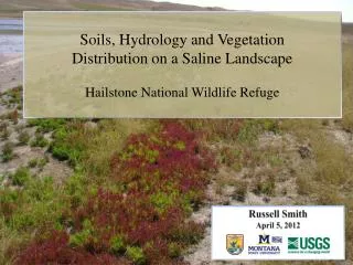
Soils, Hydrology and Vegetation Distribution on a Saline Landscape Hailstone National Wildlife Refuge. Russell Smith April 5, 2012. Hailstone NWR. Billings. Bozeman. Nelson, 2009. Regional Groundwater Salinity Concentrations. Hailstone NWR. Nelson, USFWS 2009. Hailstone Basin.

Russell Smith April 5, 2012
E N D
Presentation Transcript
Soils, Hydrology and Vegetation Distribution on a Saline LandscapeHailstone National Wildlife Refuge Russell Smith April 5, 2012
Hailstone NWR Billings Bozeman Nelson, 2009
RegionalGroundwater SalinityConcentrations Hailstone NWR Nelson, USFWS 2009
Hailstone Basin Watershed Area = 12,634 hectares Reservoir Area = 226 hectares Volume = 2,168,461 kiloliters Courtesy Google Maps - Terrain
Elevation of Groundwater USFWS 2009
1941 1954 1962 1991 2003 Nelson, USFWS 2009 1979
Hailstone Reservoir at 54% Salt - 2003 TDS levels exceeding 500,000 ppm (Seawater ~ 34,000 ppm) Problem Elevated waterfowl and wildlife mortality. Nelson, USFWS 2009
Crop Fallow Saline Seep Google Earth Image, 2011
Saline Seep Development McCauley & Jones, 2005
Non-stress Condition Effects of Salinity on Vegetation Stress Condition Seelig 2000
Problem Elevated salinity & selenium causing severe waterfowl and wildlife mortality. Goals Examine vegetation distribution, landscape position, hydrology and soil chemistry. Compare abiotic conditions with vegetation.
Objectives Select sampling points within transects at various locations at Hailstone Examine vegetation characteristics Measure landscape features Determine hydrology at sample points Examine soil chemistry Identify associations between abiotic conditions and vegetation characteristics
Objective: Vegetation D C B A
Objective: Vegetation
Objective: Vegetation 50 cm x 50 cm (2500 cm2) sampling frame vegetation identified percent cover estimatedfor each species
Objective: Vegetation Species Characterization – Wetland Indicator Status From U.S. USFWS Biological Report 88 [26.9] 1988, Revised 1993.
Objective: Vegetation Species Characterization – Salinity Tolerance Salinity Tolerance Low Medium High USDA Plants Database
Objective: Vegetation Salicornia rubra - glasswort, swamp fireweed USDA Plants Database
Objective: Vegetation Suaeda calceoliformis - seepweed USDA Plants Database
Objective: Vegetation Distichlis spicata – saltgrass USDA Plants Database
Objective: Vegetation Poa pratensis – Kentucky bluegrass Photo: Matt Lavin
Hydrologic Characteristics Objective 3) Measure indications of hydrology (depth to saturation)
Objective: Soils germinant 0-2 cm 2-5 cm seedling 5-10 cm mature roots 10-20 cm
Synthesize Vegetation Characteristics and Abiotic Condition Objectives 5) Compare vegetation characteristics with abiotic conditions and use data to help refuge managers determine revegetation strategies for soil stabilization
Objective: Synthesis VEGETATION % Canopy Cover Species Type Point Elevation & Distance to Water Surface EC LANDSCAPE SOILS N-P-K %OM Saturation Depth HYDROLOGY
Summary of Observations • Banded vegetation patterns are representative of unique abiotic conditions at Hailstone. • Soil salinity and saturation are closely linked based on position from water (lake or swale) and depth. • An environmental gradient exists where salinity and soil saturation values are highest closer to the lake and lowest in the upland positions.
Recommendations • Build a revegetation model based on observational data, field scale seeding and planting trials, and soils and hydrologic data from the newly exposed lake bed. • Organize areas on the landscape into planting zones based on elevation, hydrology and soil salinity. Choose a variety of species and forms (seed, plugs and transplants) most suited for the conditions within each zone.
Objective: Synthesis
Thank you! GO RANGERS!!