NOAA Hydrometeorology Testbed (HMT)
150 likes | 353 Vues
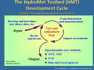
NOAA Hydrometeorology Testbed (HMT). Darin J. Figurskey Meteorologist-in-Charge NOAA’s National Weather Service Raleigh, NC. What is HMT? Ac celerating infusion of new technologies, models, and scientific results from the research into daily forecasting operations of the NWS.

NOAA Hydrometeorology Testbed (HMT)
E N D
Presentation Transcript
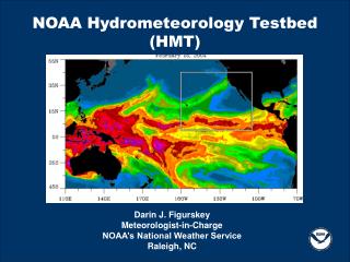
NOAA Hydrometeorology Testbed(HMT) Darin J. Figurskey Meteorologist-in-Charge NOAA’s National Weather Service Raleigh, NC
What is HMT?Accelerating infusion of new technologies, models, and scientific results from the research into daily forecasting operations of the NWS HMT WEST - Cool Season Major Activity Areas • Quantitative Precipitation Estimation (QPE) • Quantitative Precipitation Forecasts (QPF) • Snow level and snow pack • Hydrologic Applications & Surface Processes • Debris Flow • Decision Support Tools • Verification HMT Southeast – All Season, Including Hurricane Landfall HMT “Next” (TBD) • Dabberdt et. al., 2005: Multifunctional Mesoscale Observing Networks, BAMS, pp. 961-982 • Ralph et. al., 2005: Improving Short-Term (0–48 h) Cool-Season Quantitative Precipitation Forecasting Recommendations from a USWRP Workshop, BAMS, pp. 1619-1632
Marty Ralph NOAA/ETL-PACJET HMT is about… A National Testbed Strategy with Regional Implementation
Brief Summary of HMT-West • Targeted California's flood-vulnerable American River Basin for the first full-scale deployment. • Operations were focused on the North Fork of the American River Basin between Sacramento and Reno. • Water from the American River Basin is a critical resource for California's economy and natural habitats. • The threat of flooding poses an extremely serious concern for the heavily populated downstream area. • The frequent impact of prolonged, heavy winter precipitation from concentrated “atmospheric rivers" of moisture, originating in the tropical Pacific, underscores the flood vulnerability.
Specific HMT-West Objectives • Attaining accurate QPE over the basin with high spatial resolution. • Demonstrate new high-resolution forecast models tailored to the HMT area. • Accurately mapping the height of the melting layer and monitoring its evolution. • Improving the understanding of orographically-influenced winter storm airflow and precipitation development processes. • Demonstrate the concept of a regional HMT as a conduit to infuse new science and technology into operations.
HMT Observing Systems Precipitation Disdrometers Precipitation Gauges Soil Moisture, Snow WE, Depth Surface Energy, Streamlevel Radars, Profilers and Sounding Systems S-PROF X-POL Snow pillow GPS
Big Bend Field Site (elev. = 5705 ft) Lots of snow to contend with… ~7’ ~8’
Why HMT-Southeast (HMT-SE)? • The Southeast U.S. is faced with serious flooding when tropical storms make landfall, and can suffer from complex winter season precipitation involving rain, snow, and freezing rain. • Selection of the area centered on the Tar-Neuse River Basins is made based on several considerations: • the region extends from coastal estuaries to the summit of the Appalachians Mountains, and thus encompasses the geographic conditions required • the region experiences the types of storms that have been the focus of planning for HMT’s next regional Implementation • leverages efforts through NOAA’s Sea Grant program (CIFLOW), the NOAA in the Carolinas program, the NOAA Southeast and Caribbean Regional Team (SECART) and others
HMT – SE Operational WorkshopFebruary 3 – 5, Chapel Hill • Major Activity Areas • Quantitative Precipitation Estimation (QPE) • Quantitative Precipitation Forecasts (QPF) • Hydrologic Applications • Decision Support Tools • Verification • Societal Impacts As determined through consolidation of highest priorities of workshop attendees made up of NOAA, state, academic partners
Potential Activities • QPE • Optimal distribution of real-time rain gauges • Improved, automated quality control techniques • QPF • Improved understanding of how regional features affect deep convection and precipitation patterns • Assess and verify near-term model performance • Hydrologic Applications • Improve coupled modelling (sky, stream, sea) • Additional water-level observations (river and coasts) • Decision Support & Societal Impacts • Gridded hydrologic forecast development • Briefing tools to assist with impacts • Verification is a part of all of this
Next Steps • HMT – SE Research Workshop • Focus on matching operational requirements with research resources (required equipment, expertise, impact, $$) • Development of the HMT – SE Science Plan • Specific set of operational requirements and research goals to improve forecast and warning operations • Begin HMT – SE • FY10 or FY11 • Duration: estimated 2 – 3 years • Evaluate and consider HMT – Next