Download
1 / 48
480 likes | 589 Vues
The Canadian Census, conducted every 5 years, is the country's largest survey, providing crucial demographic, social, and economic data. Established in 1666 by Intendant Jean Talon, the census has evolved significantly over centuries. Key milestones include the first national census in 1871 and the introduction of self-enumeration in 1971 to enhance data quality. The census now offers insights into the entire population, including ethnicity and citizenship status, reflecting changes in Canadian society. Understanding its history aids in grasping the significance of census data today.

E N D
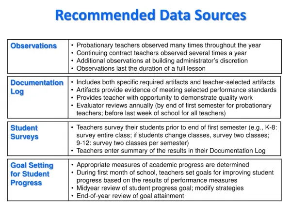
Imporatnt Data Sources • Census • IMDB • Ethnic Diversity Survey • Longitudinal Survey of immigrants to Canada
Canadian Census • The national census is Canada’s largest survey, conducted every 5 years. It gathers demographic, social, and economic information for the population, and provides information for small areas.
A brief history of Canada’s census • Canada's first census was initiated by Intendant Jean Talon in 1666. • The census counted a total of 3,215 inhabitants in the colony and recorded their age, sex, marital status and occupation. • Between 1666 and 1871, 98 colonial and regional censuses were conducted. • Gradually, more questions were added to the census. the colony's the colony's
A brief history of Canada’s census • Canada was confederated in 1867. Under Section 8 of The Constitution Act of 1867 (formerly The British North America Act), a census was to be taken in 1871 and every tenth year thereafter. • The first national census was conducted in 1871. It counted the population of the four original provinces of Canada: Nova Scotia, New Brunswick, Quebec and Ontario
A brief history of Canada’s census • Two major changes were made to the 1881 census: all census takers were required to take an oath of secrecy (a pledge still required today). • The census was extended to include British Columbia, Manitoba and PEI.
A brief history of Canada’s census • The 1951 Census was the first census to include all ten provinces and two territories (because Newfoundland did not became part of Canada until 1949). • This census also provided information for small areas such as counties, municipalities, cities, towns, etc
A brief history of Canada’s census • In 1956, the first nationwide mid-decade census was conducted. • In 1966, the second mid-decade census of the entire country was taken. • 1971 marked the 100th anniversary of the first national census. Under the new Statistics Act, it became a statutory requirement to hold censuses of population and agriculture every five years
A brief history of Canada’s census • In 1956, the first nationwide mid-decade census was conducted. • In 1966, the second mid-decade census of the entire country was taken. • 1971 marked the 100th anniversary of the first national census. Under the new Statistics Act, it became a statutory requirement to hold censuses of population and agriculture every five years
A brief history of Canada’s census • Before 1971, census was conducted through home visits and interviews. • Self-enumeration (whereby respondents complete their own questionnaire) was introduced in 1971. This method minimized enumerator error and improved data quality; it also helped to address privacy concerns and respondent burden. • Two questionnaires were used in 1971. The "short" form distributed to two-thirds of Canadian households covered the basic population questions and nine housing questions. The "long" form, distributed to the remaining third.
A brief history of Canada’s census • The 2001 Census is the most recent available (the most recent census was conducted in May 2006, but only limited data have been released.) • Between May 1 and May 12, 2001, all households received a census questionnaire. An adult in each household is asked to fill in the questionnaire and mail it back to Statistics Canada. • The questionnaire has two versions: the short form was sent to 80% of the household with 7 questions; the long form was sent to 20% of the household, containing the same 7 questions plus 52 additional questions • For 2% of the population, who live in remote areas and on Indian reserves, a census representative completed the questionnaire during a household interview. • Starting with the 2001 Census, StatCan began to provide data for common-law couples (both opposite sex and same sex) with and without children living at home.
Census Contents • The questionnaire consists of 10 groups of questions.
Group 1 1. Basic population information (Questions 1-6): • Name • Sex • Date of Birth • Marital status • Is this person living with a common-law partner? • Relationship to person 1.
Group 2 Activities of daily living (Q7-8) • Does the person have disability? • Does the condition affect the person at school, work, or other activities (transportation, leisure)
Group 3 • Socio-cultural information (Q9-23): • Place of birth • Citizenship • Is his person now, or has this person even been, a landed immigrant? • Year of landing • Official language ability (English and French) • Other languages • Language most often spoken at home/ any other languages used on a regular basis in home. • Language first learned at home in childhood and still understand • Ethnicity (of ancestor) • Aboriginal status • Minority status • Indian/First nation status • Treaty Indian/Registered Indian • Religion
Group 4 Mobility (Q24-25) • Place of residence one year ago • Place of residence 5 years ago
Group 5 Education (Q26-31) • Highest grade of secondary or elementary school attended • Years of education at university • Years of schooling in other institutions (rather than university and secondary schools) • Was the person attending school in the last 9 months? • Certificate/diploma/university ever obtained • Major field of study of the highest degree/certificate/diploma
Group 6 Place of birth of parents (Q32) • a new question used to assess socio-economic conditions of second-generation Canadians.
Group 7 Household activities (Q33) Last week, how many hours did this person spend (1) doing unpaid housework; (2) looking after children with no pay; (3) providing unpaid care to seniors?
Group 8 • Labour market activity (Q34-50) • Hour doing paid work • Unemployment • Job prospect in the next 4 weeks • Is the person looking for employment? • Is the person ready to accept a job? • When did the person last work? • Employer • Type of industry • Occupation • Main activity at work
Group 8 (continued) • Labour market activity (Q34-50) • Self-employment • Address of workplace • mode of transportation to work • language most often spoken at workplace/other languages spoken regularly at workplaces • number of weeks worked in 2000 • employment status (FT vs. PT)
Group 9 • Income (Q51) • Employment income • Self-employment income • From government income (Old Age Security Pension; Canada or Quebec Pension plan; EI; others) • Other income (dividends; interests; RRSP; child support, scholarships)
Group 10 • About dwellings (H1-H8) • Which person pays for the dwelling (rent, mortgage, tax, utilities etc.) • Ownership (rented or owned) • Total number of rooms; number of bedrooms • Year of original construction • Is this dwelling in need of major repair? • Yearly payment of all utilities • Monthly rent • Monthly mortgage/property tax/expected selling price/condominium fees
Census Geography • Census Division (CD) • Census Subdivision (CSD) • Forward Sortation Area (FSA) • Census Metropolitan Areas (CMA) • Census Agglomeration (CA) • Census Tracts (CT) • Census Dissemination Area (DA) (formerly called Enumeration Areas, EA) • Block Faces
Census Geography CD: census division • Each county, regional district, regional municipality is called a CD • In 1996, there were 288 in Canada; 49 in Ontario
Census Geography CSD: census subdivision: • these are subdivisions of CD • it refers to municipalities, Indian reserves, and unorganized territories • each city, town and village is a CSD
Census Geography FSA: forward sortation area • the first 3 characters of the postal code • each CSD can be divided into many FSAs
Census Geography CMA: census metropolitan area • used for a large urbanized core together with adjacent urban/rural areas that have a high degree of economic and social integration with that core • delineated around an urban core having a population of at least 100,000 • once designated as a CMA, it is always a CMA • each CMA consists of one or more CSDs that meet at least one of the following criteria: • the CSD is entirely within the urbanized core • at least 50% of the employed labour force living in the CSD works in the urbanized core • at least 25% of the employed labour force working in the CSD lives in the core
Census Geography CA: census agglomeration • used for an urban region of at least 10,000 people • each CA includes one or more CSDs that meet the same criteria as those for CMA • if the population drops below 10,000, that CA is eliminated from the CA program
Census Geography CT: census tract • smaller census divisions that form the CSDs in large urban-centered regions • they are defined using the following criteria • has easily recognizable borders • has a population of 2,500-8,000, with a preferred average of 4,000 • with greatest possible social economic homogeneity • has a compact shape • in many cases, a CT is equivalent to a neighbourhood or community
Census Geography DA (dissemination area) • smallest census geography, for which census data are disseminated. It is a new census geography, replacing the enumeration area (EA) as a basic unit for dissemination. • composed of one or more blocks. They are uniform in terms of population size, targeted from 400 to 700 persons to avoid data suppression. • DA boundaries respect the boundaries of CSDs and CTs. They mainly follow roads, but may follow other features (such as railways, water features, power transmission lines) • A DA within a DA is formed when the population of apartment or townhouse complexes meets or exceeds 300 persons.
Confidentiality • information collected through census is confidential to protect privacy • when data are disseminated to public and researchers: • no name and address are released • only aggregated data are made public • all numbers of rounded randomly upwards or downwards to a multiple of 5 • all areas (DA or CT) with less than 40 persons are suppressed (becoming a zero) • if the data refers to 6-digit postal codes, area with population less than 100 are suppressed
Where and how to get census? • download from Stats Can’s website. • from university libraries. • from CERIS • purchase from Stas Can.
IMDB (1) 1 What is IMDB? • IMDB stands for Immigration Database. • It is not a single database; it is a system of database consisting of a number of relational databases. • Currently, only 2 databases are available: • landing records for all immigrants who arrived in Canada between 1980 and 2005 • tax files (T1 General) for the immigrants who arrived in Canada between 1980 and 1999 (with a capture rate of 57%) • CIC and Statistics Canada planned to add 5 more databases to the IMDB, (not done yet): • immigration data system overseas • visitors data system • refugee claimant database • T-4 sp (other income) • T-4 sm (income from business)
IMDB (2) 2. What variables does IMDB include: • It includes all the variables that are parts of the landing paper and tax return form.
IMDB (3) What data has CERIS received? • CERIS has received a number of CDs from Statistics Canada. • One CD contains individual landing records for all immigrants who came to Canada between 1980 and 2005. • The others contain a number of tables derived from tax files, 1980-1997. Each table is a cross-tabulation with 5-6 dimensions.
IMDB (4) Tax files have 2 types of tables: Type (1): tables for in-migration toward each province: • In-migration by immigrant class • In-migration by level of education • In-migration by language ability • In-migration by intended occupation • In-migration by country of origin Type (2): tables for out-migration away from each province • Out-migration by immigrant class • Out-migration by level of education • Out-migration by language ability • Out-migration by intended occupation • Out-migration by country of origin
IMDB (5) Each table (in both types) provides the following information: • number of immigrants who reported employment income • amount of employment income they reported • number of immigrants who reported self-employment income • amount of self-employment income they reported • number of immigrants who collected welfare • amount of welfare they reported collecting • number of immigrants who collected UI benefit • amount of UI benefit they reported collecting
IMDB (6) 4. Limitations of the Data • Although the landing records have a ‘Destination’ variable (usually a municipality), that variable is reliable only at the CMA level, but not reliable at lower levels of geography. • The tax data are not individual records; they are aggregates for groups of immigrants. In its current form, the tax data has a major limitations: • they are grouped by provinces, not by metropolitan cities; • tax data cannot be broken down to CSD, CT and EA levels; • intra-urban geographical analysis cannot be done. • (This is not a technical problem; it is a confidentiality concern)
IMDB (7) How to request the data • available only to CERIS-affiliated researchers. • Graduate students can also use the data for their thesis research, but request must be sponsored by their advisor who is a CERIS-affiliated researcher. • the researcher should prepare a one-page description of her/his research project, • Send the one-page description (through e-mail) to the data committee chair. Can I request customized tables? • Yes. you can request special tabulations from Stats Can. • Before you send your request, it is important to prepare a good data structure.
Ethnic Diversity Survey (1) Funded jointly by Statistics Canada and Canadian Heritage There are two primary objectives: • to better understand how people's backgrounds affect their participation in the social, economic and cultural life of Canada • to better understand how Canadians of different ethnic backgrounds interpret and report their ethnicity.
Ethnic Diversity Survey (2) • The target population are persons aged 15 years or over • Respondents were selected from those who answered the long questionnaires of the 2001 Census. • Responses to the ethnic origin question were divided up to form the two main categories: • CBFA (one third of the sample) • Non-CBFA (two thirds of the sample) • The final sample was 57,242 persons. 42,476 responded. Response rate of 75.6%
Longitudinal Survey of Immigrants to Canada(1) • Designed to examine the first four years of settlement in Canada • Objectives are two-fold: • study how new immigrants adjust to life in Canada over time • provide information on the factors that can facilitate or hinder this adjustment.
Longitudinal Survey of Immigrants to Canada(2) Topics covered in the survey: • language proficiency • housing • education • foreign credential recognition • employment • health • values and attitudes • the development and use of social networks • income • perceptions of settlement in Canada.
Longitudinal Survey of Immigrants to Canada(3) Target population consists of immigrants who • arrived in Canada between October 2000 and September 2001 • aged 15 years or older at the time of arrival • landed from abroad as permanent residents
1996 Core Tables Description • The data set consists of a series of cross tabulations and profiles (123 in total) at various levels of geography: from the whole country to CMA, CTs, and EAs. • The Tabulations are grouped into 3 parts on the basis of geographical scales: • The highest level of geography • Intermediate level of geography • Lowest level of geography
Part 1 (Highest-Level)has 4 cross-tabulations with 43 geographical units.
Part 2 (Intermediate level) has 123 group profiles for 155 geographical units
Part 3 (lowest level) has 4 cross-tabulationsThe first 3 tables are at CT levels; the last is at CT and EA levels.