Hydrogeological Dual Domain Modeling Research Plan
Conducting hydrogeophysical and hydrogeologic research for dual domain transport modeling to improve contaminant migration prediction.

Hydrogeological Dual Domain Modeling Research Plan
E N D
Presentation Transcript
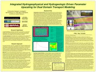
John Shafer Michael Waddell Camelia Knapp Susan Hubbard Mike Kowalsky Greg Flach Mary Harris Maggie Millings Figure 1. Top: 50 MHz GPR reflection section from the vicinity of the study area, showing good energy penetration to depths in excess of 30 m, and coherent reflectors at ~18 m. Bottom: Summed amplitude decay curve displayed in red, showing the decaying amplitude to the maximum recording time Figure 2. Seismic velocity tomogram collected beneath the H-Tank area at the Savannah River Site between boreholes separated by 42m. The depth range is 40-70m below ground surface., and the velocity range is 1500-1900 m/s. Integrated Hydrogeophysical and Hydrogeologic Driven Parameter Upscaling for Dual Domain Transport Modeling Collaborative Research Investigation Sponsored by U.S. DOE Office of Biological and Environmental Research Research Plan Hydrogeophysical Characterization: Surface and tomographic seismic and radar data will be collected at the site to provide information about the facies architecture and internal hydrological properties (table). Surface seismic and ground penetrating radar (GPR) data will be collected within a 2.5 dimensional grid across the site, and subsequently calibrated with wellbore data to refine the existing facies architecture at the site. The surface seismic data will also be processed to obtain estimates of acoustic impedance. Tomographic radar and seismic data will be collected at key locations along the surface traverses and used to estimate hydrological properties at the local scale. For this statistical analysis, co-located measurements of facies properties (available from analysis of core) and borehole, CPT, and flowmeter log data will be compared with the tomographic geophysical attribute estimates to establish relationships between the hydrogeological and geophysical parameters. The tomographic data will then be used with the developed relationships and within a stochastic framework to provide high resolution estimates of the hydrological zonation for use within the dual porosity model. Through integration of the crosshole and surface acoustic impedance data, we will extend the local-scale facies zonation interpretations to the site scale. Both surface and tomographic data quality is expected to be excellent. An example of surface GPR data and crosshole seismic data collected near our study site are shown in Figures 1 and 2, respectively. Research Hypotheses Our basic hypothesis is significant improvement in the prediction of contaminant migration can be achieved through finer scale understanding of hydrogeologic heterogeneity, which dominates advective transport, and incorporation of this understanding in groundwater flow and solute transport modeling. Our working hypothesis is fine spatial scale (1 m resolution or less) characterization of hydraulic conductivity and porosity can be achieved through an integration of hydrogeophysical measurements and analyses with understanding of the subsurface depositional environment and the hydrogeologic facies configuration. Further, improvement in prediction of subsurface contaminant migration can be achieved by incorporating the finer scale hydrogeologic heterogeneity in a dual-domain transport model. Research Approach Our research approach is two-fold: 1) spatially-dense integrated hydrogeophysical characterization using multiple complementary lines of evidence including surface and borehole ground penetrating radar (GPR) and seismic data, cone penetration testing (CPT), borehole logging, sediment/facies descriptions from core, and borehole flowmeter and slug testing, and 2) high-resolution groundwater flow and dual-domain transport modeling based on 3D hydrogeophysical mapping developed from the above and a priori optimal parameter specification. Motivation: Conventional characterization approaches (e.g. wellbore, direct push) produce only point or vertical line measurements of very localized conditions. Thus comprehensive field site characterization is cost prohibitive, and models are severely constrained from lack of data. Just as medical imaging technology has reduced the need for invasive exploratory surgery, geophysical methods hold promise for rapid, non-destructive, relatively inexpensive and vastly improved characterization and monitoring of the shallow subsurface. While promising, additional research is needed to further develop these methods for a variety of geological settings. We anticipate that integrated geophysical and hydrogeological testing can provide dense, three-dimensional, data sets for explicit incorporation into a field-scale flow model hydraulic conductivity field of comparable resolution. The primary improvement anticipated is more accurate simulation of bulk plume movement, and to some extent dispersion. However, even with improved characterization of this nature, small- to intermediate-scale heterogeneity is present and significantly influences contaminant migration. Therefore, the impact of sub-grid scale heterogeneity on plume dispersion must be cost-effectively addressed as part of an overall, multi-scale, treatment of subsurface variability. We propose a dual-domain formulation to efficiently handle sub-grid scale heterogeneity. Figure 3. Field study site adjacent the P-Area Reactor Facility. Preliminary characterization revealed a TCE plume emanating from the northwest section of the reactor facility. FY06 / Year 1 Activity FY06 / Year 1 activities will focus primarily on planning and performing Phase I field work in Summer 2006, as described below. CPT and wellbore: The project team has designed a synergistic layout (Figure 3) of borehole/well installations, piezometers, and direct push/CPT tests. The direct push lithologic logs will define stratigraphy of core study area. Ground water samples at 10 locations and 5 or more depths per location will define the plume extent and distribution of TCE contamination. Piezometers are planned at 3 locations placed in upper and lower aquifer zones for defining the local hydraulic gradient. Three initial wells at 2 locations serve several purposes, one of which is to enable borehole tomography. Geophysics: The project team plans to acquire and process (1) zero-offset and multi-offset P- and S-wave vertical seismic profiles (VSPs), (2) 2.5D surface seismic reflection data, and (3) 2.5 D ground penetrating data, and (4) several vertical radar profiles (VRPs) at available boreholes. The P- and S-wave VSPs will be acquired in two existing wells that penetrate through the first aquitard at approximately 30 m. Data from the VSP surveys will be used to evaluate the vertical velocity field and provide the necessary information to optimally design the 2.5D surface seismic survey while providing high fidelity calibration of geology to the surface seismic data. Multi-offset and azimuth VSP data will provide detailed information on (a) lateral and vertical stratigraphic heterogeneity, (b) subsurface velocities , and (c) noise and signal attenuation, necessary for designing the acquisition parameters for the 2.5D surface survey. In addition these data will be used in generating acoustic and/or elastic impedance models to assist in mapping hydrologic zones and facies. The 2.5D seismic reflection survey to be conducted in 2006 will be designed to image the top of the first aquitard. The depth of this unit at the P Reactor Area ranges from 21 m to 37 m below land surface. At the SRS, surface wave noise is a major problem with seismic data and often masks P-wave reflections. To attenuate surface waves, various two-dimensional filtering techniques will be applied including but not limited to frequency-wave number (FK), Tau-p, and Karhunen-Loeve (KL) filtering. At the P Reactor Area the filtering techniques listed above will be tested. Concurrently with the seismic acquisition, a surface ground penetrating radar (GPR) survey will also be conducted. The surface GPR data acquisition will involve the use of the PulseEKKO 100 GPR system with 50, 100, and 200 MHz antennas, thus allowing geostatistical analysis of the radar reflection data as a function of frequency that will facilitate interpolation and extrapolation of the hydraulic properties of the study area away from the borehole measurements. The GPR data will enable quantitative assessment of the internal anatomy of the sedimentary layers, filling the scale gap between the borehole and seismic information. Thus, we will take advantage of the geostatistical characteristics of the radar reflection data that inherently demonstrate a significant dependence on the antenna frequency, emphasizing the importance of the scale of measurement. The GPR processing will map key dielectric interfaces from the ground surface to 30 meters, which, when correlated with wellbore data, will be used to assess hydrogeological zonation. At a yet higher level, we will then integrate the GPR results with the seismic reflection data to build a subsurface model with vertical and horizontal resolutions spanning from a few centimeters to a few meters. Dual Domain Transport Modeling: For field-scale transport through unconsolidated sediments, small-scale advection likely controls mass transfer between "mobile" and "immobile" regions. Adequate mechanistic approaches for defining optimal dual-domain parameter values in this setting have not been developed and/or validated. Our objective is to relate mobile-immobile region partitioning and the first-order mass transfer coefficient to readily characterized system parameters, such as facies and permeability distributions and hydrologic conditions. We hypothesize that such relationships exist and can be developed from a series of carefully designed numerical experiments. To illustrate the feasibility of the concept, consider a perfectly layered system comprised of high and low permeability intervals, with a mean hydraulic gradient not parallel to the bedding planes. In this situation, flow in high conductivity zones is mostly parallel to the bedding, while flow in the low permeability zones is roughly normal. In the context of a two-region model, advective transport into and out of the low conductivity “immobile” regions plus diffusion is described by Equation (1), which could provide a mechanistic basis for choosing an optimal two-region mass transfer coefficient. Under more realistic conditions, we anticipate a more complex relationship than Equation (1), but nonetheless one that can be deduced from numerical experimentation. We intend to perform such experiments and then validate (or invalidate) the inferred “optimal” dual-domain parameter settings through comparison to concentration data acquired from both high (mobile) and low (immobile) conductivity intervals at the P-Area field site.