Download
1 / 7
70 likes | 89 Vues
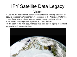
Utilize global satellite constellation data for arctic & antarctic research. Study past & future environmental changes. Predict polar ice, ocean & land variations. Secure data for future scientists & understand climate impact.

E N D
IPY Satellite Data Legacy • Vision: • Use the full international constellation of remote sensing satellites to acquire spaceborne ‘snapshots’ of processes in the Arctic and Antarctic. • Use these snapshots as gauges for comparing past and future environmental changes in the polar ice, ocean and land. • In the spirit of the IGY, secure these data sets as our legacy to the next generations of polar scientists.
IPY Legacy Objectives Programmatic Heritage • IGOS-Cryosphere Theme Report • GIIPSY Science Requirements Report • GIIPSY AGU Town meeting
Legacy Data SetScience Drivers • Understand the polar ice sheets sufficiently to predict their contribution to global sea level rise • Understand sea ice sufficiently to predict its response to and influence on global climate change and biological processes • Measure how much water is stored as seasonal snow and its variability. • Understand glaciers and ice caps in the context of hydrologic and biologic systems and their contributions to global sea level rise. • Understand the interactions between the changing polar atmosphere and the changes in sea ice, glacial ice, snow extent, and surface melting. • Understand the spatial distribution of permafrost, its interactions with other systems or processes, and predict its response to climate change. • Improve understanding, observing and modeling capabilities of lake and river ice and its influence on energy, water and biochemical cycling, and aquatic ecosystems.
IPY Legacy Objectives • Sea level rise, and hemispheric climate (Glaciers, ice caps and ice sheets): 1) For the first time, one summer, one winter SAR snapshot of the polar ice sheets, glaciers and ice caps. Near simultaneous imagery at L, C, and X band, polarimetric quad pole for documenting ice surface physical parameters. 2) For the first time, pole-to-coast multi-frequency InSAR measurements of ice surface velocity.3) For the first time, repeated X-band InSAR topography for detecting local changes in ice sheet elevation associated with motion of subglacial water. 4) For the first time, one summer, one winter, high resolution visible/near IR/ TIR snapshot of the entirety of the polar ice sheets, glaciers and small ice caps followed with bimonthly coverage of select glaciers for snow-zone mapping 5) Continued measurements of ice surface elevation from radar and laser altimeters (spaceborne and airborne) for volume change 6) Continued, daily visible and infrared medium-resolution imaging of the entirety of the polar ice sheets, glaciers and ice caps and to be compiled into monthly maps. 7) Continued, daily medium-to-coarse resolution active and passive microwave images of the polar ice sheets, ice fields and ice caps for melt extent 8) Continued measurements of the gravity field for mass balance.
IPY Legacy Objectives • Ocean circulation and polar air-sea interactions (Sea ice): 1) For the first time, L-band SAR mapping of the Arctic ocean and marginal seas sea ice cover for leads and ridges. 2) For the first time, repeat fine resolution SAR mapping of the entire Southern ocean sea ice cover for ice motion 3) For the first time, SAR and optical fine resolution mappings of the entire Arctic ocean 4) Continued 3-day medium resolution SAR mapping of sea ice covered waters for motion, and melt pond coverage 5) Continued passive microwave observations of sea ice concentration and extent 6) Continued laser and radar altimeter measurements of ice thickness and sea surface topography 7) Measurements of IPY Polar Geoid • Regional climate, precipitation and hydrology (Terrestrial snow cover): 1) Daily medium resolution visible/near IR/TIR observations of all snow covered terrain 2) Daily passive microwave observations of snow covered terrain for determination of snow water equivalent
IPY Legacy Objectives Changing permafrost and Arctic climate (Permafrost)1) For the first time, one complete high resolution snapshot of all polar permafrost terrain at L, C and X band. 2) For the first time, one complete, high resolution visible and thermal IR snapshot of all polar permafrost terrain 3) Continued medium and coarse active and passive microwave observations of all polar permafrost Aquatic ecosystems, transportation and hazards (Lake and river ice) 1) For the first time, pan-arctic high and medium resolution microwave snapshots of fresh water- break/freeze-up 2) For the first time, pan-arctic high and medium resolution visible, near IR and TIR snapshots of fresh water- break/freeze-up 3) Seasonal, low-frequency (6-10 GHz) passive microwave observations of lake ice thickness
IPY Legacy Summary • IPY provides an international framework for acquiring coordinated spaceborne observations of the polar regions. • IPY spaceborne observations complement, and can serve as a prototype for, larger international ventures such as IGOS, GEOSS and GEO. • The confluence of international science programs, technical capabilities and the IPY present a once-in-a-life-time opportunity for gathering data essential for understanding changing polar climate and its global impact.