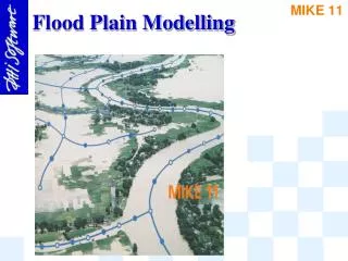
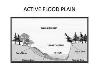
ACTIVE FLOOD PLAIN
ACTIVE FLOOD PLAIN. ACTIVE FLOOD PLAIN. Active flood plain is a flat area with alluvial deposits adjacent to a water body which is regularly flooded.

ACTIVE FLOOD PLAIN
E N D
Presentation Transcript
ACTIVE FLOOD PLAIN • Active flood plain is a flat area with alluvial deposits adjacent to a water body which is regularly flooded. • Active Flood Plains are narrow strips of land along the Indus and its tributaries varying from 24 to 40 km in width. They are inundated almost every year, covered with rich alluvium and are suitable for agriculture.
ACTIVE FLOOD PLAIN • Old flood plains cover extensive areas between the active flood plains and the desert areas in the lower Indus Valley.
ALLUVIAL FANS • An alluvial fan is a fan-shaped deposit formed where a fast flowing stream flattens, slows, and spreads, typically at the exit of a canyon onto a flatter plain. • Alluvial fans are fan-shaped deposits of water-transported material (alluvium). They typically form at the base of topographic features where there is a marked break in slope.
ALLUVIAL FANS • An alluvial fan is a fan-shaped or cone-shaped deposit of gravel, sand, and smaller materials. • An alluvial fan is a wide pile of sediment deposited where a river leaves the mountains. • A fan shaped deposit of coarse alluvium (sand and gravel) brought by a stream from the slopes of a hill or mountain.
ALLUVIAL TERRACES • A plain formed from the deposition of alluvium usually adjacent to a river that periodically overflows. • Alluvial terraces or bars are the areas of higher ground formed between two rivers.It is rich in alluvium locally known as do-ab, ideal for agricultural activities.
BRAIDED CHANNELS • A river channel which is divided into several channels separated by alluvium deposits. • Braided channels are subdivided at low-water stages by multiple midstream bars of sand or gravel.
CUESTA • A ridge of limestone with a steep slope on one side and a gentle slope on the other side. • A ridge with a gentle slope on one side and a cliff on the other.
DRAINAGE • The naturally occurring channeled flow formed by streams and rivers which removes water from the land surface. • Drainage is the natural or artificial removal of surface and sub-surface water from an area.
DRY LAKES • A nearly level area at the bottom of an undrained desert basin, sometimes temporarily covered with water.
GULLY EROSION • A gully is a landform created by running water, eroding sharply into soil, typically on a hillside. Gullies resemble large ditches or small valleys, but are meters to tens of meters in depth and width.
INLAND DRAINAGE • Inland drainage is that drainage in which rivers do not reach an ocean or sea but empty their waters in a lake or an inland sea. • A pattern of streams that drains toward the centre of basin rather than towards the sea is called inland drainage.
interfluves • All terrain can be classified in one or two groups. These groups are valleys and interfluves. Valleys are areas of lower terrain, while interfluves are areas of high terrain located between valleys. • These are the areas of high terrain located between valleys.
LEVEES • A natural or artificial embankment of a river which confines the river within its channel and prevents flooding. Raised banks of a river with deposited material.
LOW LYING AREAS • A depression created in an area which is lower than the adjoining areas.
MANGROVE SWAMP • A type of wetland forest made up of salt-adapted trees found along tropical coast areas. It provides a rich habitat for strong biodiversity and helps to protect coasts from erosion. • Biodiversity is a measure of the health of ecosystems. • Biodiversity is the variety of species, their genetic make-up, and the natural communities in which they occur.