International Workshop on Land Cover Mapping for the African Continent
Join us for a comprehensive workshop on land use and land cover mapping for Africa. Discover the importance of LULC mapping, technology advancements, and creating synergy for sustainable management and development. Learn about key initiatives and explore new dynamic environmental reports. Aiming to enhance mapping techniques and data dissemination, this workshop covers a range of topics from biodiversity to disaster management.

International Workshop on Land Cover Mapping for the African Continent
E N D
Presentation Transcript
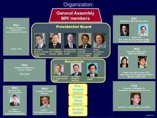
INTERNATIONAL WORKSHOP ON LAND COVER MAPPING FOR THE AFRICAN CONTINENT UNEP TSINGHUA –UNV. USDI RCMRD Has been organized by ORGANIZATION UNV. CALIFONIA
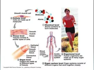
DAY 1 Summary Land use and land cover (LULC) are critical components for analyzing the complex interactions between human activities and environmental issues. Mc: Peter Gilruth the Director DEWA Morning Session Hussein Farah CEO- RCMRD Official opening: Achim Steiner the Executive Director UNEP Patrick Warugute Director DRSRS Peter Gilruth • The government has enshrined environmental issue in its constitution and its vision 2030 a development blue print planning document • Department’s effort in the production of similarly important products like: The Wetland Atlas; The Natural resource Capital Atlas • LCLU mapping is quite important for the African continent • Diverseness of its resources like oil, timber and mineral resources • Ecosystem services & valuation • Available technology is essential to forge for new frontiers ahead • infrastructure but in terms of ecological services accorded by nature • The need to know how ecosystems function and interact for informed sustainable management for sound development choices • Systematic LULC mapping will be of great assistance to these nations in: • policy making, planning • management of resources • monitoring the status of the Environment. • Building synergies to develop and improve fundamental datasets infrastructure • Very important for other ongoing initiatives like REDD+, GHG inventory & the SOE reporting • Commended the USGSS and its partnership with UNEP • Mentioned a number of products like the Kenya Atlas and the State of Environment e.tc . • New product -dynamic State of the Environment report dubbed as the “UNEP live”
DAY 1 Summary Workshop Objectives, desires & outcome Morning Session Jean Patcher GEO Global land cover Task Georgios Sarantakos LULC mapping in Eastern by RCMRD • A pool of Scientists • Methodologies • Release of Global land cover data • Release of a30m water product • geoportal for data and info dissemination • Development of harmonized products, translation riles (legend) • Geo activities I • n Africa and the objectives • Examples of Biodiversity –Ecosystems, Energy and geo resources • Disasters • Water • Climate for development • Forest carbon monitoring • Disaster management –Fire • Energy Potentials- Bioenergy and Solar • Many other users • The world has evolved & technology advanced • synergies and partnership is critical • collect this data and how have we shared this information especially with the ground trothed data • Experiences, technological advancement are important in this process • Share methodologies utilized. Needs for type of classification • Collaborative synergies are important, the user needs need be identified UNEP • Functional structure of RCMRD • RCMRD products • mechanisms of data presentation • Definition LU and LC • How they do LCLU mapping at Global, regional, national and local or ecosystem • Challenges; Funding ; Capacity ; Validation; Institutional arrangement; Methodology and guidelines • Why UNEP was formed • What they support • Global regional National and Global assessments • MEAS’s with lots of focus on CBD • Areas with the most and least progress • UNEP is not a mapping agency but they hint what, why and how the environment has changed • Information dissemination strategy • Challenges; data collection on a global scale; maintain regional and thematic balance; acquisition, analysis, and packaging of satellite data in a user friendly format and integration with GIS
DAY 1 Summary Workshop Objectives, desires & outcome Text Afternoon Presentation1: 30m global landcover products from China: progress and perspectives Presenter: Prof Peng Gong • Started with a brief introduction of the University • Strategies they have employed for LC mapping • Methodology and steps undertaken by their agency in the development of a LC • The two mapping approaches for classification • intensified test of algorithms for china lc mapping With the use of CBEST they are able to map a big country like China very quickly to an accuracy level of about 70% • There is an advancement to actually perform a dynamic landcover changes e.g of water bodies • The landcover type can be aggregated into 10 major classes but then additional information is appended • They have been doing a number of classification like • Maximum likelihood classifiers • Tree classifier • Unsampled classifiers • Sampled classifiers • They are able on an annual basis to produce a 250 m resolution dataset • With distinctiveness of different crop phenology, different crop species can be mapped out. • Landcover mapping hotspots most frequently lc mapped area Group work
Thank You Gabriel Sanya Enjoy the rest of the day
4 1 2 3 Discuss, demonstrate and review the methods, qualities, innovations and technical issues involved in the new global LULC mapping products the 30 m Discuss and develop a plan for validating and improving the 30 m land cover map product over the African continent. Define regional training needs for building capacity to improve the national and regional land cover datasets for Africa Discuss data sharing and applications for the high resolution global land cover map for carbon cycling, biodiversity monitoring (particularly Aichi Targets) greenhouse gas monitoring, and other environmental issues. Objectives