Download

1 / 10
160 likes | 639 Vues
Key Question:. How are Boundaries Established, and Why do Boundary Disputes Occur?. Land Boundaries. Not just a line, but also a vertical plane that cuts through subsoil, rocks and the airspace above-coal, gas & oil reserves often cross these lines.

E N D
Key Question: How are Boundaries Established, and Why do Boundary Disputes Occur?
Land Boundaries • Not just a line, but also a vertical plane that cuts through subsoil, rocks and the airspace above-coal, gas & oil reserves often cross these lines. • Belgium, Germany & Netherlands argued over coal seams & natural gas reserves. • Kuwait Oil drilling prompted the 1991 Gulf War (Rumaylah Reserve)
Land Boundaries • 3 Stage Evolution of Boundaries: • definition-a document is created that indicates exact landmarks; • delimitation-cartographers place the boundary on the map; • demarcation-boundary markers such as steel posts or concrete pillars, fences or wall marks the boundary
Land Boundaries • Frontier-a zone of separation that keeps rivals apart can be natural or manmade-such as Korean DMZ. • Boundaries keep out adversaries or keep citizens inside-limit smuggling, migration, etc. • Internal boundaries-provinces or states within a larger state.
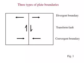
Types of Boundaries • Geometric-straight line boundary such as US-Canada or many in Africa. • Physical or Natural-Political Boundary-river, crest of a mountain range or some other physical landmark • Cultural or Anthro-Geographic Boundary-breaks in the human landscape, such as most of Europe’s boundaries
Aozou Strip: A Geometric Boundary Fig. 8-9: The straight boundary between Libya and Chad was drawn by European powers, and the strip is the subject of controversy between the two countries.
Left-the Demilitarized Zone between NorthKorea & South Korea is heavily defended by both sides Bottom left-the US-Canadian border is the longest undefended border in the world. Bottom right-the Rio Grande forms the border between Mexico and the United States which is porous enough to allow million of illegal immigrants.
Genetic Boundary Classification • Richard Hartshorne, a leading political geographer developed this classification system; • Antecedent Boundary-physical landscape defined the boundary well before human habitation-Malaysia-Indonesian boundary on Borneo is sparsely settled. • Subsequent Boundary-Vietnam-China border results from a long period of modification. • Superimposed-forcibly drawn boundary that cuts across a unified cultural boundary-New Guinea-Indonesia West Irian & Papua New Guinea in the East. • Relict boundary no longer serves its purpose, but the imprint is still evident in the landscape-Vietnam-North South boundary, West and East Germany boundary, especially in Berlin.