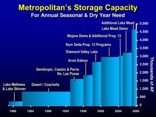
dry year
6 unknowns from 9 samples. 9 unknowns from 12 samples. 10 unknowns from 16 samples. Ortho-rectification. Image displacement, 1st pass. Image Displacement Analysis. GCP Displacement Analysis and Cloud Interference. Original images. Image Laplacians. Reference map. Swath imagery.

dry year
E N D
Presentation Transcript
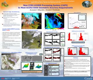
6 unknowns from 9 samples 9 unknowns from 12 samples 10 unknowns from 16 samples Ortho-rectification Image displacement, 1st pass Image Displacement Analysis GCP Displacement Analysisand Cloud Interference Original images Image Laplacians Reference map Swath imagery Reference map Swath imagery Image displacement after orbit correction Dr = -0.179° Dg = -0.033° Dt = 0.204 s Scan range: 55.37-0.021° Correction for GHA: 0.982 s Covariance Matrix AVHRR NOAA-18, Aug, 20, 2006 NSS.HRPT.NN.D06232.S1928.E1940.WI 217 GCPs selected Covariance Matrix GCP matching between image Laplacians yields sharper maximum. And also, it is much more efficient in the case of thin/small clouds. Achieving Sub-Pixel Accuracy First step: Fit parabola through 3 points in X and 3 points in Y. The decide, which case is applicable: New CCRS AVHRR Processing System (CAPS)to Meet GCOS/CEOS Geometric Accuracy Requirements Konstantin V. Khlopenkov, Alexander P. Trishchenko Improved Image Georeferencing Master image from MODIS. Distribution of selected GCPs. DEM map at 250 m/pixel resolution • Accurate image georeferencing including orthorectification is essential for analysis of SCDR (Satellite Climate Data Records) for annual variability, trends, indicators. • Precise geolocation is fundamental for climate applications: • Generation of land-water masks • Analysis of fire disturbance • Landcover maps • Long-term data records for NDVI, etc. • Incorrect geolocation increases spatial noise in the long-term data records, which masks the real signal or produces biased results. dry year Canadian/CCRS AVHRR Processing System (CAPS) AVHRR georeferencing with CAPS • Image displacement is analyzed in the swath projection; • Single pass of ortho-rectification (elevation correction); • Displacement matrix is solved to adjust the orbit, sensor orientation, and siderial time, in order to correct for geolocation errors; • Uses MODIS composite imagery as a reference (master) image; • Uses DEM map 250 m/pix resolution; • GCP fitting (chip matching) is applied to laplacians of the images; • Achieves sub-pixel geolocation accuracy (1/3 FOV as per GCOS/CEOS requirement); • Geolocation files (similar to MOD03) can be producedfor each swath. • Improved performance. Geolocation error is calculated by comparing the reprojected AVHRR scene with MODIS reference (composite) image in LCC projection. AVHRR georeferencing with CAPS (complex winter scene) Displacement vectors (map projection method) Summary Some of the advantages and unique features of the CAPS system are: • It relies on the high geolocation accuracy of the MODIS 250m/pix imagery. • The accuracy in image georeferencing is within ±1/3 pixel along and across the scan direction. • Precise orthorectification of the imagery (using the DEM map at 250 m/pix with bilinear interpolation); • Sub-pixel accuracy in finding the positioning difference between the images; • Efficient reprojection routine that uses the concurrent gradient search and bilinear interpolation; • High performance (processing time is ~60–90 sec per granule). The CAPS system is now employed for re-processing the entire AVHRR 1-km archive assembled at CCRS starting from AVHRR NOAA-6. Acknowledgements • This work is conducted in the NRCan/ESS Program “ Enhancing Resilience in a Changing Climate” and CCRS/UCS Program • Work is also supported by the Canadian Space Agency under the Government Related Initiative Program (GRIP) and Canadian IPY.