National Freight Network
National Freight Network. National F reight Network Components. National Freight Network. Critical Rural Freight Corridors. Primary Freight Network 27k limit + 3k Current Future Importance Importance. Remainder of the Interstate System.

National Freight Network
E N D
Presentation Transcript
National Freight Network Components National Freight Network Critical Rural Freight Corridors Primary Freight Network 27k limit + 3k Current Future Importance Importance Remainder of the Interstate System
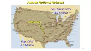
MAP-21 Language for Designation of NFN & PFN • NFN General language • NHS; • Aerotropolis; • Intermodal Connectors. • PFN Language: • “Based on an inventory of national freight volume conducted by FHWA…” • PFN Factors for Consideration: • Origins and destinations of freight movement in the United States; • Total freight tonnage and value of freight moved by highways; • Percentage of annual average daily truck traffic in the annual average daily, traffic on principal arterials; • Annual average daily truck traffic on principal arterials; • Land and maritime ports of entry; • Access to energy exploration, development, installation, or production areas; • Population centers; • Network connectivity.
MAP-21 Language for Designation of CRFC • CRFC Language: • A State may designate a road within the borders of the State as a critical rural freight corridor if the road - • Is a rural principal arterial roadway and has a minimum of 25% of the annual average daily traffic of the road measured in passenger vehicle equivalent units from trucks (FHWA vehicle class 8 to 13); • Provides access to energy exploration, development, installation, or production areas; or • Connects the Primary Freight Network, a roadway described in paragraph (1) or (2), or Interstate System to facilities that handle more than – • 50,000 20 foot equivalent units per year; or • 500,000 tons per year of bulk commodities
Next Steps • Critical Rural Freight Corridors: • Issue guidance on designation of Critical Rural Freight Corridors (Summer 2013); • Compile Critical Rural Freight Corridors designated by State DOTs (Fall-Winter 2013). • National Freight Network: • Combine PFN and CRFC designations into NFN and release initial NFN (Winter 2013-Spring 2014)
Defining Terms • What are energy exploration, development, installation, or production areas? • How can we “provide access” to energy exploration, development, installation, or production areas? • What is a connection to: • the primary freight network? • the Interstate System? • a rural principal arterial roadway that has a minimum of 25 percent of the annual average daily traffic of the road measured in passenger vehicle equivalent units from trucks (FHWA vehicle class 8 to 13)? • a roadway that provides access to energy exploration, development, installation, or production areas? • What are facilities that handle more than: 50,000 20-foot equivalent units per year; or 500,000 tons per year of bulk commodities?
Development of Analytical Techniques and Approaches • What are the approaches for determining 25 percent of the annual average daily traffic of the road measured in passenger vehicle equivalent units from trucks (FHWA vehicle class 8 to 13)? • What techniques and approaches can be used to translate trucks and facility production into: 50,000 20-foot equivalent units per year; or 500,000 tons per year of bulk commodities? • What methodology should be used to analyze access to energy exploration, development, installation, or production areas?
Identifying National and Local Data Sources What data sources does your State have for: • Annual average daily traffic of the road measured in passenger vehicle equivalent units from trucks (FHWA vehicle class 8 to 13); • Annual average daily traffic, annual average daily truck traffic, percent trucks; • Energy exploration, development, installation, or production areas; • Roadways: • Rural Principals • Interstate System • Primary Freight Network • Facilities that handle: • 50,000 20-foot equivalent units per year; or • 500,000 tons per year of bulk commodities
How to Submit data for CRFC • Where and when do I have to submit the data? • What is the file format? • What are the require fields and attributes? • which criteria it meets • route name • latitude, longitude • other liner reference • beginning and end point
Case Studies Does your State have experience collecting any of the data items we are requesting for CRFC? Has your State developed methodology on how to model and designate roads based on the criteria presented today?
Final Comments What is the most critical challenge that your State will encounter during the designation of Critical Rural Freight Corridors?