Download
1 / 4

E N D
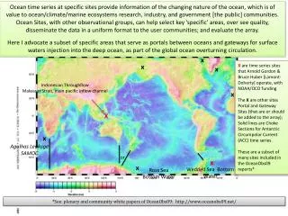
Ocean time series at specific sites provide information of the changing nature of the ocean, which is of value to ocean/climate/marine ecosystems research, industry, and government [the public] communities. Ocean Sites, with other observational groups, can help select key ‘specific’ areas, over see quality, disseminate the data in a uniform format to the user communities; and evaluate the array. Here I advocate a subset of specific areas that serve as portals between oceans and gateways for surface waters injection into the deep ocean, as part of the global ocean overturning circulation. x x X are time series sites that Arnold Gordon & Bruce Huber [Lamont-Doherty] operate, with NOAA/OCO funding The X are other sites Portal and Gateway Sites (that are or should be added to the array); Solid lines are Choke Sections for Antarctic Circumpolar Current (ACC) time series. These are a subset of many sites included in the OceanObs09 reports* x Indonesian Throughflow Makassar Strait, main pacific inflow channel x X x Agulhas Leakage SAMOC or x x Weddell Sea Bottom Water Ross Sea Bottom Water *See: plenary and community white papers of OceanObs09: http://www.oceanobs09.net/
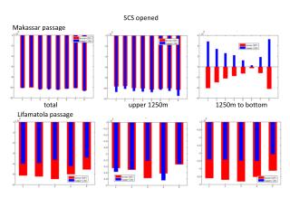
Indonesian Throughflow (ITF): Inflow ~ 14 Sv; outflow ~ 15 Sv, 1 Sv imbalance over 3 years [noise level] Long time series potential NOAA/OCO Mak ITF >1250 m overflow 200-2000 m Karimata ~1 Sv ? Australian Integrated Marine Observing System [IMOS] Indonesian Through Flow Moorings 15 Long time series potential The italics numbers in black represent transport values based on pre-INSTANT data. The red numbers are the 2004-2006 3-year mean transports measured by INSTANT. In Lifamatola Passage the green number is the INSTANT overflow transport >1250 m, representing the overflow into the deep Seram and Banda Sea
Something changed in 2007, peaked in 2008/09, maybe decreasing in 2010* Shallower stronger, warmer Makassar throughflow thermocline max thruflow 2004 1997 2011 * Gordon, Huber, Metzger, Susanto, Hurlburt, Adi “South China Sea Throughflow Impact on the Indonesian Throughflow” WCRP Denver October 2011
500 m above bottom Weddell Sea Bottom Water Time Series x sea floor Temperature, benthic 500 m Salinity, benthic 500 m Bottom speed Maintenance coordinated with UK BAS Seasonal cycle High freq masks low freq? Monthly bottom temperature Gordon et al, 2010, Nature GeoSci McKee et al 2011, JGR-Ocean Meridith et al, 2011, GRL warm Interannual variability of Weddell Sea Bottom Water correlates to SAM and ENSO; no 10-year trend apparent. cold 2006 1999 Data set now extends to March 2011


![Q1 2008 Pacific Geo Quarterly Business Review [Pacific Channel]](https://cdn2.slideserve.com/5239610/q1-2008-pacific-geo-quarterly-business-review-pacific-channel-dt.jpg)