The Evolution of Perspective Drawing and Mercator's Mapping Innovations
This article explores the development of perspective drawing as a transformative technique in art, highlighting its roots in the work of al-Haytham and the invention of the camera obscura. It discusses how perspective drawing addresses the realism of three-dimensional objects on two-dimensional surfaces. Additionally, it delves into the challenges of cartography, particularly in relation to the Mercator projection developed by Gerardus Mercator, which solved navigation issues by distorting geographical accuracy to maintain angular relationships. This intersection of art and science shaped visual representation in the Renaissance.

The Evolution of Perspective Drawing and Mercator's Mapping Innovations
E N D
Presentation Transcript
Perspective (continued)
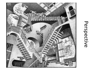
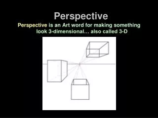
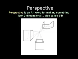
Perspective drawing addresses the issue of producing a two-dimensional image of a three-dimensional object. The simplest way to make such an image is simply to “project” the object onto a plane, but the result is not realistic. It amounts to taking the shadow, with the sun directly overhead.
For a painter, the projection is usually horizontal, but the principle is the same. Note that the dotted lines are all parallel. As we have seen, the difficulty is that this does not take into account the distance from the object to the observer. Distant parts of the object will appear to have the same size as nearer parts, and this produces an unrealistic effect.
Perspective drawing also “projects” the object onto a plane, but the projection lines are not parallel. They are the lines that rays of light would follow from the object to the eye of the observer.
One of the contributions of al-Haytham was the realization that light travels in straight lines. He demonstrated this by building a “camera obscura”, or “dark room”. Light was admitted into a completely darkened chamber through a single tiny hole, and projected onto a screen on the opposite wall. The image is inverted.
Many others found that a camera obscura was a good way to study the physics of light or the construction of images. They were made in many sizes and shapes, including small ones that are the precursors of the modern “camera”. Some had a ground glass window for viewing the image; some had an internal prism to turn the image rightside-up. The larger the hole, the brighter the image, but the smaller the hole, the better the resolution. It is possible to do better with a lens.
Perspective drawing can be regarded as a natural consequence of al-Haytham’s observation. It revolutionized art, partly because it made paintings and drawings look better. But there is also a philosophical issue. The use of perspective establishes the importance of the observer. This emphasis on the individual was in tune with the spirit of the Renaissance.
Another important arena in which projections arise naturally is cartography, the making of maps.
The fundamental problem is that the earth is round and paper is flat. One solution is to make round “maps”. But this is limited by the level of detail that can be achieved on a globe of a practical size.
The problem is not too serious for maps that cover only a small portion of the earth’s surface, because the effect of the curvature is not that great. But when the great age of exploration began, there was a desperate need for maps as an aid to navigation. Having an inaccurate map could be extremely dangerous.
Gheert Cremer (1512 – 1594) was a Flemish cartographer. Like many people of his time with scholarly aspirations, he latinized his name, thinking that Latin sounded more intellectual. “Cremer” means “merchant”, so he changed to the Latin equivalent: “Mercator”. Gerardus Mercator made some excellent globes, some of which still survive. But he is mostly remembered for inventing a way of making maps, the “Mercator projection”.
The mercator projection draws the lines of longitude as parallel lines, instead of letting them get closer together as they near the poles. In effect, the horizontal scale increases the farther you are from the equator. To compensate, Mercator also increased the vertical scale the farther it is from the equator. The effect is that the lines of latitude get farther and farther apart.
A mercator projection map is good for local navigation because angles are preserved. However, distances change at different latitudes. Canada looks even bigger than it actually is.
A mercator projection map is good for local navigation because angles are preserved. However, distances change at different latitudes. Canada looks even bigger than it actually is. These maps are excellent for short range navigation, but not so good for long range navigation. They also cannot extend as far as the poles: to do so would require an infinitely tall map.
There are many other schemes for making maps. Some are designed to preserve areas. This gives a more accurate indication of the relative sizes of different territories. But it comes at the cost of distortion in the angles.
This map was drawn in 1587 by Mercator’s son Rumold. Europe and Africa are depicted much more accurately than the Americas.
Maps were made from information received from sailors when they returned from their voyages. This was a nightmare for cartographers, especially when they got inconsistent information from different sources. One interesting way this happened was that sailors were used to following a compass heading, heading always in the same direction. Now if they went north or south, they would follow lines of longitude. If they went east or west, they would follow the lines of latitude. But what happened if they went, say, north-west? They thought they would travel in a straight line. In fact, they would follow a spiral path around the earth, called a loxodrome by mathematicians and a “rhumb line” by sailors. Mercator admired a mathematician named Pedro Nunes who had worked this out, and Mercator was able, for the first time, to show rhumb lines on his charts.
Mercator also made celestial maps, showing the stars and planets, and even made celestial globes. At one point, Mercator fell under suspicion of heresy, partly because he travelled widely to gather information for his maps. He was arrested and spent several months in prison. Several other arrested at the same time confessed that they had doubts about the tenets of the Catholic Church and were burned at the stake or buried alive. Mercator refused to confess, so he was eventually released. However, he was ruined financially, and shortly afterwards left the Netherlands and moved to Duisburg in the Duchy of Cleves, where he spent the rest of his life.