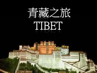
青藏之旅 TIBET
780 likes | 916 Vues
青藏之旅 TIBET. The Red Line is the route traveled from Xi-Ning, Qinghai to Mount Everest base-camp in Tibet 红 線是路途的全程 從西寧開始 直到珠峰大本营. The Qinghai-Tibetan Plateau With its glacier-covered mountains seen here from the plane, it is often called

青藏之旅 TIBET
E N D
Presentation Transcript
The Red Line is the route traveled from Xi-Ning, Qinghai to Mount Everest base-camp in Tibet 红線是路途的全程 從西寧開始 直到珠峰大本营
The Qinghai-Tibetan Plateau With its glacier-covered mountains seen here from the plane, it is often called the Roof of the World due to its high altitude (average 4,000 m or 12,000 ft.) 鳥瞰冰川縱橫的 青藏高原(平均海拔四千米 有世界屋脊之稱)
The recently completed railroad into Tibet - over rough terrain 穿山越嶺的青藏鐵路
I chose a 4 wheel drive vehicle with a local driver 我們的座駕 - 越野車 rougher but better experience 駕車雖比坐飛機或火車辛苦 但给我留下回味無窮的經歷
Much of my trip was driven on unpaved dirt roads 旅途中大部份時間都是在土路上行駛
Dirt roads are dusty 土路往往沙塵滚滾 you may wish for rain 下點雨就好了
which you may regret 结果下雨路更糟
Mountain roads are usually winding along hillsides 彎彎曲曲的山路繞着山邊向前伸延
View while driving as if you were flying in mid air 天塹險路 Scary if you look down 胆小的不要往下看
Improvised traffic sign (reads “blow horn”) 最原始的交通標誌
… the only way to cross the river is … 那… 就祗能這樣過河….
Even paved roads can be hazardous 新修的國道就一定安全嗎?
You are sharing the road with everyone and everything 公路當然是公共的
including these pilgrims who prostrate themselves all the way to their sacred destinations 小心別撞到沿途叩拜的信徒
This vast grassland calledKekexilli along Kunlun Mountain is home to these Tibetan antelopesalmost poached to extinction for theirluxurious fur 崑崙山旁的可可西里大草原是藏羚羊出沒的地方
My close encounter with a Tibetan antelope 與我近距離的藏羚羊
Tibetan gazelle 羊羚(當地人叫白屁股,不同藏羚羊)
Qinghai Lake – the largest lake in China 青海湖是中國最大的湖(水是咸的 - 我嚐過)
Blossom along the shore of Qinghai Lake 青海湖畔盛開的油菜花
Tanggula Pass(altitude 5,200 m or 15,600 ft) at the border between Qinghai and Tibet 越過這唐古拉山口(海拔五千两百米) 就從青海跨進了西藏
This is the land of big sky, mountains and lakes 這 里 天 寬 地 闊
Sometimes it is hard to tell where land ends and sky begins 天地合一的景象
Lake Nam Co(altitude 4,700 m or 14,100 ft) is the largest sacred lake in Tibet 納木錯湖(海拔四千七百米) 是西藏最大的聖湖
Lake Yamzho Yumco(altitude 4,440 m or 13,320 ft) is another beautiful sacred lake 羊卓雍錯湖(海拔四千四百米) 是另外一個美麗的聖湖
A rare opportunity for me to swim at such altitude (Lake Yamzho Yumco) 我難得有机會暢游羊卓雍錯湖
This part of the Himalayas looks like the rain forest 這里有點像熱帶雨林
Nyingchi area is particularly lush shown herealong Nyang River - a tributary of Yarlungzangbo 林芝地區(尼洋河畔- 雅魯藏布江的支流)号稱西藏的江南
The mighty Yarlungzangbo River nourishes the northern slope of the Himalayas 沿喜馬拉雅山脈北麓的 雅鲁藏布江
Yarlungzangbo Canyon(seen here from the plane), the deepest land canyon on earth, remains largely inaccessible. Through this canyon, the Yarlungzangbo River flows south to become the Bramaputra River in India 雅鲁藏布大峽谷是世界陸上最深的峽谷 (要走進去談何容易) 雅鲁藏布江水從這里向南流進印度
China’s mighty Yangtze River originates from glacial melt similar to this one in the Qinghai – Tibetan Plateau 長江源於青海的冰川
So does LancangRiver (the source of the Mekong River) seen here flowing by the city of Qamdo 瀾滄江源於青藏. 它穿過昌都城向南流去成為了湄公河的上游
… and Nu River(the source of the Salween River which empties into the Indian Ocean through Myanmar)seen here in eastern Tibet 怒江 也是源於青藏. 它流經缅甸進入印度洋
Anxiously waiting for the heavy fog to clear at the Everest basecamp 在大本营耐心等待 難得一見的珠峰真面目
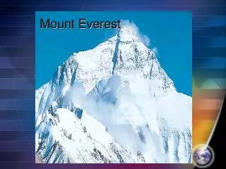
Mount Everest-local name Qumolangma Finally a clear view (summit altitude 8,848 m or 26,500 ft) 我终於看到了珠峰(峰頂海拔 8,848米)
Just as exciting as the scenery are the culture and life of the people living there 以下介紹當地人民的文化, 生活
Highland barley is the main crop grown here 當地主要種植的糧食是 青稞麥
Beautiful barley fields in Denqen, eastern Tibet 丁青縣的麥田給人一種仙境般的感覺
August is harvest time Winter starts early in Tibet 八月是收割季節 這里冬季漫長
Nomad’s tent (this one woven with yak fur) and his dog (Tibetan Mastiff ) 牧民的 耗牛毛藏包(相當保暖) 和藏獒(非常忠心, 凶猛)
Some go solar 野外的太陽能電源
Yaks are the only beasts of burden which can tolerate the high altitude and freezing weather 耗牛是唯一能在這低氧, 低温環境下生存的勞動力
White yak is a symbol of luck 白耗牛是吉祥的象徵