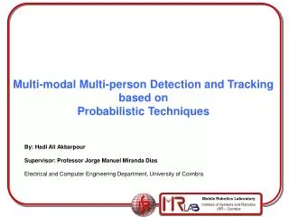
Multi-modal Multi-person Detection and Tracking based on Probabilistic Techniques
290 likes | 481 Vues
Multi-modal Multi-person Detection and Tracking based on Probabilistic Techniques. By: Hadi Ali Akbarpour Supervisor: Professor Jorge Manuel Miranda Dias Electrical and Computer Engineering Department, University of Coimbra. The Outlines. Using a dispersed network of sensors

Multi-modal Multi-person Detection and Tracking based on Probabilistic Techniques
E N D
Presentation Transcript
Multi-modal Multi-person Detection and Tracking based on Probabilistic Techniques By: Hadi Ali Akbarpour Supervisor: Professor Jorge Manuel Miranda Dias Electrical and Computer Engineering Department, University of Coimbra
The Outlines • Using a dispersed network of sensors • Using several modalities, in addition to use a dispersed network • Dealing with data registration • Using two kinds of sensors arrangements: Static and Moving sensors) (By using a mobile robot in addition to the fixed sensors) • Human Presence Detection & Tracking • Using Bayesian techniques
The Signal Acquisition Devices Video camera Laser Range Finder A pan-tilt head Mobile Robot Microphone
Some proposed scenes and their configurations Outdoor Indoor
The motivation of using a probabilistic framework • For inference: previous knowledge Likelihood Normalizing factor model of system • For filtering: Normalizing factor prior distribution Likelihood (sensor model)
Data registration • Spatial Data Registration • temporal Data Registration
Spatial Data Registration • Commensurate Sensors • Non-Commensurate Sensors Step 1- Calibrating the camera network Step 2- Calibrating the camera network and LRF Step 3- Calibrating the camera network and Mic. array Having all sensors calibrated !
Our Setup for Camera Network Calibration Using Svoboda Toolbox
Cameras and Reconstructed Points by the Svoboda Calibration Toolbox
Extrinsic Calibration of Stereo Camera and 2D LRF Configuration Rigid Coordinate Transformation Coordinate systems convention
Calibration Steps • Step 1: Placing the laser pointer, somewhere out of the LRF´s FOV which is planar. • Step 2: The LRF starts to capture range signals form the area of its view. • Step 3: The laser pointer has to be moved to hit the sensing plane of the LRF. (The times of these hitting must be registered) • Step 4: The stereo camera has to capture and register the images at the hitting times of the step 3. • Step 5: Repeating the steps 1 to 4, about 20 times, meanwhile that all of sensors are capturing the data. • Step 6: Extracting the laser pointer positions in the recorded frames by the stereo cameras and converting each paired 2D point to a single 3D point (a real world Cartesian coordinate). • Step 7: Converting the data recorded by LRF module (at the hitting moments) into a Cartesian coordinate, the same as step 6. • Step 8: Feeding the outputs of steps 6 and 7 to the GetProcrustes algorithm (which is described further) and get outputs. The outputs will be a rotation matrix and a translation vector between the stereo camera and the LRF coordinates.
A sample between 20 (N) recorded samples (synchronized) The striked laser beam to the laser pointer The striked laser beam to the laser pointer Image captured by the left camera. The position of the laser pointer (red light) in this frame is (501,274) in pixel. Image captured by the right camera. The position of the laser pointer (red light) in this frame is (434,281) in pixel. The LRF reported it as 133 cm and 62 degree (62.44,117.43) cm in its local frame
Temporal Data Registration 2- Using a Network-Socket based data capturing architecture 1- Synchronizing all PCs based on Network Time Protocol (NTP) Time offsets between two PCs Withoutusing NTP Using NTP
Temporal Data RegistrationTime delays between recorded images in a camera network The left figure shows the delays between recorded frames when just the starting time is the same. The right one shows is for the same subject when the described architecture is used. The values are in ms.
Constructing a Probabilistic Distance-Color Grid IP1: Image Plane of Camera 1 IP2: Image Plane of Camera 2 CV1: View angle of Camera 1 CV2: View angle of Camera 2 LPx: Laser Plane No. x SP: Arrival sound direction plane CV1 CV2 LP1 Semi-tilt LRF LP2 LP3 IMU LP4 LP5 IP2 LP6 IP1 LP7 Camera1 SP Camera2 Microphone array
Probabilistic Parameters of the Grid Each cell of the grid Parameters and random variables Position of the cell: (row and column) Distance to the camera2 image center, in a real world scale (e.g. mm), measured by Stereo Camera, LRF and Microphones, respectively. Probability (confidence degree) of the distances Color of the cell Probability of skin-color being of the color Probability of being background Movement direction Probability (confidence degree) ofthemd
Sources of information to fill each cell of the grid Parameters of each cell is determined by fusing data from either all or some of the following sensors: 1- Stereo camera system 2- Semi-tilt Laser Range Finder 3- Microphones
1st Source: Using Stereo camera system • Finding some strong features using e.g. SIFT • Finding the distances (in real world scale e.g. mm) by using matching and then triangulation (considering that the stereo camera is calibrated) Result of this phase: Distances of matched points
2nd Source: Using tilt Laser Range Finder • It can be done in two phases: • Finding intersection between laser planes and camera2’s plane. • Transforming each seen point by LRF into camera2’s plane.
Finding intersection between laser planes and camera2 plane LP1 LP2 LP3 LP4 LP5 LP6 LP7
intersection between laser planes and camera2 plane (lines) Line 1 Line 2 Line 3 Line 4 Line 5 Line 6 Line 7 b) Transforming the range data in intersection lines into the probabilistic gradNote: These points have a confidence probability near unit
3nd Source: Microphones Arrival angle
Probabilistic Information Fusion on Range, Image and Sound Data Probabilities of distances (2nd dimension) Distance values in real world scale (1st dimension) Each of m x n double cells Final distance of the cell: Final probability of the cell:
Classification of the distances inside the grid based on close values
Classification of the distances inside the grid based on close values Class 1: Front and totally visible Class 2: Back and partially visible
Cooperation between static and mobile sensors SHU: Static Heterogeneous Sensors Unit. MHU: Mobile Heterogeneous Sensors Unit. CFACU: Central Fusing And Correcting Unit.