3 rd IMPACT WORKSHOP Brembo-Adda test case
300 likes | 479 Vues
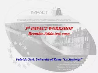
3 rd IMPACT WORKSHOP Brembo-Adda test case. Fabrizio Savi, University of Rome “La Sapienza”. On 25-28 November due to heavy rainfalls in Alpine Region (Northern Italy) a significant flood propagated along Adda river and inundated a wide portion of the riverside and the city of Lodi. L =50 km.

3 rd IMPACT WORKSHOP Brembo-Adda test case
E N D
Presentation Transcript
3rd IMPACT WORKSHOP Brembo-Adda test case Fabrizio Savi, University of Rome “La Sapienza”
On 25-28 November due to heavy rainfalls in Alpine Region (Northern Italy) a significant flood propagated along Adda river and inundated a wide portion of the riverside and the city of Lodi
L=50 km L=98 km Description of the hydrographic network L=131 km
For each gauging station • Semi-hourly water stages hydrographs • Rating curve • are available
Maximum water levels during flood were also measured in 117 points
The values of the Manning roughness coefficient can be estimated on the basis: • maps of the soil use in the floodplain • mean particle size of the river bed material • photographs of revetments
Conclusions • Input data: • Discharge hydrographs at the upstream sections of hydrographic network (XLS format) • Stages hydrograph at the downstream section of hydrographic network (XLS format) • Cross sections (including Manning roughness coefficient) (XLS-ASCII format) • DTM of the valleys (DWG format) • Data to verify the model: • Stages hydrograph at intermediate section (XLS) • Maximum observed water stages along the water courses (XLS format) • Extension of the inundated areas (along Adda river) (DWG format)