Air Masses and Fronts
760 likes | 1.76k Vues
Air Masses and Fronts. Air Mass. A large body of air in which there are similar horizontal temperature and moisture properties. Properties are largely acquired from the underlying surface. Air Mass. Air mass over cold ground Cold and dry Air mass over water More moist

Air Masses and Fronts
E N D
Presentation Transcript
Air Mass • A large body of air in which there are similar horizontal temperature and moisture properties. • Properties are largely acquired from the underlying surface
Air Mass • Air mass over cold ground Cold and dry • Air mass over water More moist How does water temp affect moisture?
Air Mass Classification • Air masses are classified according to their temperature and moisture characteristics • “continental” = dry (c) • “maritime” = wet (m) • “polar” = cold (p) • “tropical” = warm (t) • “arctic” = frigid (a) • These are combined to create categories
Air mass classification • mT = maritime tropical • warm/moist; originate over tropical oceans • cT = continental tropical • warm/dry; originate over areas like SW U.S. • mP = maritime polar • cold/moist; originate over polar oceans • cP = continental polar • cold/dry; originate over interior continents in winter • cA = continental arctic • frigid/dry; form at very high latitudes
Fronts • “Boundary between different air masses” • Types of fronts • Cold • Warm • Stationary • Occluded
Maritime Polar (mP) • Forms over the oceans at high latitudes • Moist • Cold • Can contribute to significant snowfall events in mid-Atlantic • Figure from apollo.lsc.vsc.edu/classes/met130
Continental Polar (cP) • Forms over the northern continental interior (e.g., Canada, Alaska) • Long, clear nights allows for substantial radiational cooling (stability?) • Assisted by snowpack • Dry • Cold • Figure from apollo.lsc.vsc.edu/classes/met130
Arctic (A,cA) • Similar to cP, but forms over very high latitudes (arctic circle) • Dry • Extremely cold • Figure from apollo.lsc.vsc.edu/classes/met130
Continental Tropical (cT) • Forms over southwest U.S. & Northern Mexico • Source region includes west Texas • Dry • Warm • Limited water bodies and vegetation limits effect of evaporation and transpiration • Figure from apollo.lsc.vsc.edu/classes/met130
Maritime Tropical (mT) • Forms over Gulf of Mexico as well as subtropical Atlantic and Pacific Oceans • Moist • Warm • Figure from apollo.lsc.vsc.edu/classes/met130
Air Mass Modification • Air masses can be modified once they leave their source region. • Temperature & moisture content can increase or decrease • So how are air masses modified?
Air Mass ModificationFigure from ww2010.atmos.uiuc.edu • 1. Move over warmer or colder ground
Air Mass ModificationFigure from ww2010.atmos.uiuc.edu • 2. Move over a large body of water Fig. 9-12, p. 264
Example: Lake Effect Snow Box 9-2, p. 263
Air Mass ModificationFigure from www.usatoday.com/weather/wdnslope.htm • 3. Move over a mountain range
Air Mass Modification • Stability of the air mass can also modified
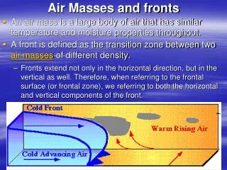
Fronts • Air masses move from source region through advection • Air masses do not readily mix together • Front – A boundary between two different air masses • Can be hundreds of miles long
Types of Fronts • Cold Front • Warm Front • Stationary Front • Occluded Front
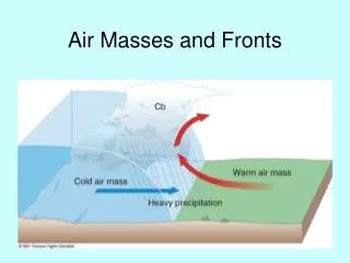
Cold Front • Cold air advances, replaces warm air at the surface • Change in wind direction/speed • Minimum in atmospheric pressure Fig. 9-14, p. 266
Cold Front Cross Section • A front is a 3-D boundary • Front slopes back over the cold air mass • Warm, less dense air is lifted • Clouds/precipitation associated with a front depend on stability and moisture • Sharp vertical motion at cold front can force thunderstorm activity Fig. 9-15, p. 266
Slope of a Front • Depends on temperature and wind differences between the two air masses • Shallow vs. steep slope
Warm Front • Warm air advances • Replaces the cold air at the surface • Change in wind direction/speed Fig. 9-17, p. 268
Warm Front Cross Section • Front slopes back over the cold air mass • Slope is more gentle than with a cold front (less thunderstorm activity) • Warm, less dense air lifted over the cold air (called overrunning) • Clouds/precipitation depend on moisture and stability, usually follow a set progression with an increase in altitude • Responsible for a lot of hazardous winter weather Fig. 9-18, p. 269
Stationary Front • Air masses at surface do not move, so the front is stationary • Overrunning still occurring, so we often still see cloudiness • Figure from ww2010.atmos.uiuc.edu
Occluded Front • Separates cool air from relatively colder air at the surface • Sometimes thought of as the “cold front catching up to warm front” • The warm air mass is found above the ground • Two types: • Cold-type occluded front • Warm-type occluded front • Figure from ww2010.atmos.uiuc.edu
Development of Occluded FrontFigures from ww2010.atmos.uiuc.edu
Cross Section of Occluded Front Fig. 9-20, p. 271
Dryline • Dry air (lower dewpoint temperatures) found to west, moist air (higher dewpoint temperatures) found to east • Temperature change is rather limited across the boundary • Common in the southern plains during the spring • It is a convergence line for wind at the surface, and is therefore responsible for initiating many of our tornadic thunderstorms in the south Plains • Motion is tied strongly to insolation, and typically exhibits a diurnal “sloshing” motion (moving eastward during the day, westward at night)
Air Masses with the Drylinewww.geog.umn.edu/faculty/klink/geog1425/images/front/dryline_airmass.jpg
Animation • Satellite • WTM
Fronts • “Boundary between different air masses” • Types of fronts • Cold • Warm • Stationary • Occluded
Identification of Fronts on a Weather Map Look for sharp changes in: a) temperature b) dew point c) wind direction d) pressure and e) cloud/precipitation patterns.
Cold Fronts • Divides cold/dry air (usually a cP air mass) from a warm/moist air mass (mT) • Cold air is advancing on the warm air • Cold air is denser, pushes warm air up and over • May result in heavy localized precipitation ahead of the front • Usually trails down and to the south of a mid-latitude cyclone
Cold Front Transition Most precipitation and deep clouds form ahead of front Cirriform clouds spread ahead of front Warm air rises in a steep fashion over intruding cold air
cP Air mass mT airmass
