East – West Corridors
210 likes | 382 Vues
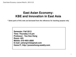
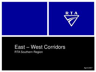
East – West Corridors. RTA Southern Region. April 2007. SYDNEY. Wollongong. Nowra. ACT. Batemans Bay. Bega. VIC. Southern Region North – South Corridors. Three main North – South Corridors: Princes Hwy Hume Hwy Federal & Monaro Hwys AUSLINK: Princes Hwy NO – (SYDNEY TO GWNNEVILLE)

East – West Corridors
E N D
Presentation Transcript
East – West Corridors RTA Southern Region April 2007
SYDNEY Wollongong Nowra ACT Batemans Bay Bega VIC Southern RegionNorth – South Corridors • Three main North – South Corridors: • Princes Hwy • Hume Hwy • Federal & Monaro Hwys • AUSLINK: • Princes Hwy NO – (SYDNEY TO GWNNEVILLE) • Hume Hwy YES – (SYDNEY TO MELBOURNE) • Federal Hwy YES – (SYDNEY TO ACT) • Monaro Hwy NO
The need for efficientEast – West Corridors • Limitations exist for freight on the Princes Highway • Sydney to Wollongong AUSLINK corridor (allowing HML / CML) extends only to Gwynneville & does not include the Princes Hwy • 25m B-doubles can not legally utilise Princes Hwy between South Nowra & Bega (H4), gazetted as “general access” only • Other main north – south routes are less restrictive • Hume & Federal Highways are AUSLINK corridors, with provision for HML / CML operation • Hume, Federal, & Monaro Highways are all gazetted to allow use by 25m B-doubles • The inland routes are therefore the preferable north – south corridors for freight • Utilisation of north – south (Sydney – ACT – Melbourne) corridors from the Illawarra & the NSW south coast therefore requires access to safe & efficient east – west corridors
SYDNEY Wollongong Bowral Shellharbour Goulburn Kiama Nowra Queanbeyan Braidwood Ulladulla ACT Batemans Bay Cooma Narooma Jindabyne Bega Bombala Eden VIC Southern RegionEast – West Corridors • Four main regions of linkage: • Access to & from Wollongong • Access to & from Shellharbour / Shoalhaven • Access to & from Eurobodalla • Access to & from Bega Valley • Each region has different characteristics presenting their own unique challenges: • Differing freight tasks • Differing topography • Differing availability of alternative routes • Differing regulatory constraints • Differing traffic mixes & road safety risks • Most east – west corridors traverse an escarpment crossing
Appin Helensburgh Wilton MR177 Appin Rd MR95 Picton Rd Bulli Mt Ousley Wollongong Port Kembla West Dapto East – West Access to & from Wollongong • DEMAND: • Coal & steel industry, and Port Kembla port • Major urban expansion at West Dapto • Proximity to Sydney • SUPPLY: • Two inland east – west routes: • MR177 Appin Rd • MR95 Picton Rd • Two coastal escarpment crossings: • Mt Ousley • Bulli Pass
Inland East – West RoutesMR95 Picton Rd • MR95 Picton Road • Currently carries approx. 14,000 veh/day with 20% heavy vehicles • High incidence of crashes due to limited overtaking opportunities & high mix of heavy vehicles • At present this route appears to be the preferred freight connection between the Illawarra / Port Kembla & Sydney / HW2 Hume Hwy / M7 Sydney Orbital • Freight volumes are expected to increase as the Port Kembla port expands – 2008 onwards • The traffic mix on MR95 needs to be monitored & managed given the high percentage of freight & increasing residential development (Macarthur area – Wilton) • Potential • While not an AUSLINK corridor, there are provisions in the 2004 White Paper for MR95 to be considered as a “transport link of regional significance” • This could see MR95 carrying HML / CML freight in the near future • Funding may become available to provide infrastructure upgrades: • Short term – additional overtaking lanes • Long term – upgrade to two lanes in each direction
Inland East – West RoutesMR177 Appin Rd • MR177 Appin Road • Currently carries approx. 11,000 veh/day with 14% heavy vehicles • The route has attracted attention in the past due to high crash rates • Together with MR95, this route serves as a freight connection between the Illawarra / Port Kembla & SW Sydney / Campbelltown • Traffic mix on MR177 needs to be monitored & managed given the high percentage of freight (Port Kembla & collieries) & increasing residential development (Macarthur area – Appin) • Potential • The route could replace MR95 as the preferred freight connection to the Hume Hwy / SW Sydney if Appin were to be bypassed & improved connectivity provided to the Hume Hwy • While not an AUSLINK corridor, there are provisions in the 2004 White Paper for MR177 to be considered as a “transport link of regional significance” • This could see MR177 carrying HML / CML freight in the near future • Funding may become available to provide infrastructure upgrades: • Short term – additional overtaking lanes • Long term – two lanes in each direction, possible Appin bypass & link to Hume Hwy
Illawarra Escarpment CrossingsMR95 Mt Ousley • MR95 Mt Ousley • Catering for approximately 40,000 veh/day, this is the main escarpment crossing in the Illawarra & is part of the AUSLINK network • Extensive de-watering systems constantly monitor & manage potential slip issues • Little practical scope to provide more lanes ~ what we have is what we’ve got • Any strategies to manage future traffic on Mt Ousley need to incorporate planning at other escarpment crossings (Bulli Pass) • Potential • Given its AUSLINK status, the route is likely to be utilised for HML / CML • Short term • - funding may become available to investigate region wide escarpment crossing strategies • Long term • possibility of upgrade to Old Mt Ousley Rd junction at base of Mt Ousley
Illawarra Escarpment CrossingsHW1 Bulli Pass • HW1 Bulli Pass • Currently carries approx. 12,000 veh/day • The route is gazetted ‘general access’ only ~ no access to 25m B-Doubles • Provides link between northern suburbs of Illawarra & Sydney via Southern Fwy & Appin Rd • Improvements to the Northern Distributor likely to increase pressure on Bulli Pass as an alternative to Mt Ousley • Potential • In the event of upgrades to MR177 (two lanes each direction, Appin bypass, improved linkage to Hume Hwy), Bulli Pass would become a network constraint adjacent the upgraded Northern Distributor • Pressure on the capacity of Mt Ousley may attract attention to Bulli Pass as an alternative • Short term • - funding may become available to investigate region wide escarpment crossing strategies • Long term • a corridor has been reserved for a possible new Bulli Pass alignment • current freight restrictions may not apply if a new alignment were to proceed
Wollongong Mittagong Bowral West Dapto Moss Vale HW25 Illawarra Hwy Robertson Shellharbour Kiama MR264 Jamberoo Mtn Rd Kangaroo Valley MR261 Nowra to Bowral Berry Nowra East – West Access to & from Shellharbour / Shoalhaven • DEMAND: • Local industry (dairy) & quarries • Growth at West Dapto & Nowra • Connectivity to Hume Highway • SUPPLY: • Three inland east – west routes: • HW25 Illawarra Hwy • MR264 Jamberoo Mountain Rd • MR261 Nowra to Bowral
Inland East – West RoutesHW25 Illawarra Hwy • HW25 Illawarra Highway • Currently carries approx. 3,000 veh/day with 7% heavy vehicles • Escarpment crossing at Macquarie Pass impedes freight access & observes high crash rates • Route is gazetted ‘general access’ only, however this does not restrict use by 19m B-doubles < 50T, semi trailers, or buses • Use of Macquarie Pass by such vehicles is undesirable, however can not be regulated due to road classification • The expansion of Port Kembla & increasing proposals for ‘inland ports’ in the Southern Highlands is expected to increase desire for use of the route by heavy vehicles • Potential • Alternative escarpment crossings at Macquarie Pass are impractical • Any strategies to manage future traffic on Macquarie Pass need to incorporate planning at other escarpment crossings • Discouraging future freight use on Macquarie Pass without the ability to regulate beyond ‘general access’ will be a challenge
Inland East – West RoutesMR261 Nowra to Bowral • MR261 Nowra to Bowral • Currently carries approx. 3,000 veh/day with 6% heavy vehicles • Route is gazetted ‘general access’ only • Two escarpment crossings – Cambewarra Mountain & Barrengarry Mountain • 42.5T load limit exists for Hampden Bridge (Kangaroo Valley) • Nowra is one of the fastest growing centres in NSW, increasing pressure on this route • Increasing complaints by the public over the use of the route by heavy vehicles • Potential • Heavy vehicle accessibility on the escarpment crossings could be reviewed, however there are few plans for potential upgrades at this stage
Inland East – West RoutesMR264 Jamberoo Mountain Rd • MR264 Jamberoo Mountain Road • Currently carries approx. 4,000 veh/day with 4% heavy vehicles, with only 1,000 veh/day traversing the escarpment crossing • 25m B-doubles permitted only between Robertson & Kangaroo Creek (above escarpment) • Escarpment crossing is extremely narrow & winding ~ less accessible than Macquarie Pass • Mainly recreational traffic • Potential • Heavy vehicle accessibility on the escarpment crossing is extremely limited, however there is little demand for improvement
Nowra Main Road 92 Bungendore Queanbeyan Ulladulla Braidwood MR51 Kings Hwy Captains Flat Batemans Bay East – West Access to & from Eurobodalla • DEMAND: • Queanbeyan & Nowra high growth areas • HQJOC • Limited alternative routes • Recreational trips • SUPPLY: • Two inland east – west routes: • Main Road 92 • MR51 Kings Hwy
Inland East – West RoutesMR51 Kings Hwy • MR51 Kings Highway • Currently carries approx. 4,000 veh/day with 6% heavy vehicles • Escarpment crossing at Clyde Mountain impedes freight access & observes high crash rates • ‘General access’ between Batemans Bay & Braidwood (incl. Clyde Mountain) • Gazetted for 25m B-doubles between Braidwood & Queanbeyan • Limited availability of alternate east – west routes, therefore only practical route for freight, commuters, & recreational traffic (ACT to Batemans Bay / coast) • Dept of Defence HQJOC currently under construction will increase pressure on capacity between Bungendore & the ACT / Queanbeyan • Main Road 92 will increase heavy vehicle traffic • Potential • The corridor was one of several CPoM ‘pilot’ studies undertaken across NSW • Strategic outcomes from pilot study are under review using latest available data & software • Potential projects include provision of overtaking lanes, junction & road safety treatments • Consideration could be given to uncoupling bays to assist accessibility across Clyde Mountain
Inland East – West RoutesMain Road 92 • Main Road 92 • The route will form a connection between Nowra & the ACT / Queanbeyan, two of the fastest growing regional centres in NSW • Currently undergoing enhancement to improve accessibility • Potential • The route will be monitored to gauge its effect on MR51 & the Princes Hwy at Nowra
Cooma Bermagui HW4 Snowy Mtns Hwy Bega MR91 Pambula to Bombala Bombala Pambula Eden Imlay Rd East – West Access to & from Bega Valley • DEMAND: • Timber, fishing, & local industries (dairy) • Access to forestry areas • SUPPLY: • Three inland east – west routes: • HW4 Snowy Mountains Hwy • MR91 Pambula to Bombala • Imlay Rd (Forestry controlled)
Inland East – West RoutesHW4 Snowy Mountains Hwy • HW4 Snowy Mountains Highway • Currently carries approx. 2,000 veh/day with 12% heavy vehicles • Escarpment crossing at Brown Mountain impedes freight access & observes high crash rates • Brown Mtn gazetted for 19m B-Double CML (55T) • Access by 25m B-doubles is restricted, with uncoupling bays provided either side of Brown Mountain • B-double accessibility on HW4 west of Monaro Hwy (Cooma) restricted to ‘general access’ • Potential • There is no short term likelihood of upgrading HW4 west of Monaro Hwy to 25m B-double status given length of road requiring upgrade & a number of bridges that would need to be replaced • Brown Mountain uncoupling bays are believed to be a satisfactory solution to improving access across Brown Mountain (& a similar solution could be considered for MR51 at Clyde Mountain)
Inland East – West RoutesMR91 & Imlay Rd • MR91 Pambula to Bombala • Currently carries approx. 1,500 veh/day (less in regional areas) with 8% heavy vehicles • 25m B-doubles are gazetted to the west near Monaro Hwy, but restrictions exist elsewhere • Potential – the restricted sections are not deemed suitable for heavy vehicles • Imlay Road • The route mainly services forestry vehicles travelling between the industry on the coast & Bombala • Approx. 300 veh/day, carrying 450,000 to 500,000 Tonnes/yr • Equates to an estimated figure of approx. 15% heavy vehicles • Potential – Imlay Rd is a Forestry controlled road
Summary of Challenges • Escarpment crossings are prevalent on all east – west routes • Road safety, traffic efficiency, & freight accessibility on all escarpment crossings • Limits to potential for upgrades on Mt Ousley mean other escarpment crossings such as Bulli Pass may need to be upgraded • Uncoupling bay strategy (similar to Brown Mtn) could be a solution to improving accessibility on Kings Hwy (Clyde Mtn) • Increasing industry & expansion of Port Kembla consume spare capacity • Additional overtaking lanes could be considered for routes such as Kings Hwy, and Picton & Appin Rds • Alternative to Mt Ousley could be an upgrade to Bulli Pass • Timber logging routes need to be managed • Industrial development places pressure for freight on unsuitable routes • Macquarie Pass
Summary of Challenges • AUSLINK & selected routes will allow HML / CML • Bridge & pavement maintenance concerns on all routes • Network upgrades attract freight to deficient links • Bulli Pass (in the event of Northern Distributor & Appin Rd upgrades) • Kings Hwy (due to Main Road 92) • High growth areas increase freight on existing routes • Sydney, Port Kembla – Mt Ousley, Bulli Pass, Picton & Appin Rds • ACT / Queanbeyan, Nowra – Kings Hwy & Main Road 92