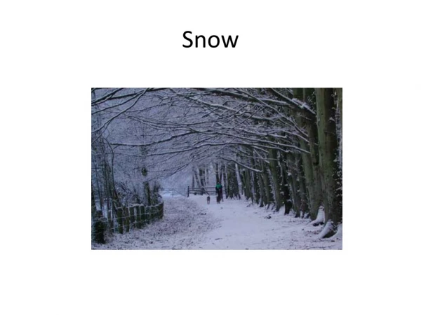
Download
1 / 40
430 likes | 664 Vues
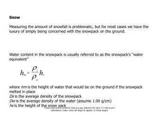
Reasons Snow Important. 10% of the Earth's surface is covered by glacial ice, with snow covering the glacial ice. * Small changes in climate can have very large effects on precipitation as snow, the amount of water stored as snow, and the timing and magnitude of snowmelt runoff. .

E N D
Reasons Snow Important • 10% of the Earth's surface is covered by glacial ice, with snow covering the glacial ice. • * Small changes in climate can have very large effects on precipitation as snow, the amount of water stored as snow, and the timing and magnitude of snowmelt runoff.
Hydrologic Cycle Water movement from the atmosphere to the oceans and continents occurs as precipitation, including rain, snow, sleet, and other forms.
Hydrologic Cycle On the continents, water may be stored temporarily, but eventually returns to the oceans through surface/groundwater runoff or to the atmosphere through evapotranspiration.
Hydrologic Cycle For this class, we concentrate on the contributions to the hydrologic cycle from snow and snowmelt. Additionally, we will investigate some of the unique properties of snow that result in avalanches.
Phase diagram – H20 The phase diagram is divided into three regions, each of which represents a pure phase. The line separating any two regions indicates conditions under which these two phases can exist in equilibrium.
Phase diagram – H20 The point at which all three curves meet is called the triple point. For water, the triple point is at 0.01° C and 0.006 atmospheres.
Phase diagram – H20 Lets change pressure, and see how the boiling point and freezing (melting), point of water deviate from normal magnitudes
Air Masses and Fronts Air mass: regional scale volume of air with horizontal layers of uniform temperature and humidity. m = maritime c = continental T = tropical A = arctic P = polar
Air Masses and Fronts m = maritime c = continental T = tropical A = arctic P = polar As these air masses move around the Earth, they can begin to acquire additional attributes. In winter, an arctic air mass (very cold and dry air) can move over the ocean, picking up some warmth and moisture from the warmer ocean and becoming a maritime polar air mass (mP) - one that is still fairly cold but contains moisture. If that same polar air mass moves south from Canada into the southern U.S. it will pick up some of the warmth of the ground, but due to lack of moisture it remains very dry. This is called a continental polar air mass (cP).
Mountain Climates of Western North America • Four mountain ranges parallel west coast of North America • Coast Ranges • Alaska Range • Cascades Range • Sierra Nevada • Ranges lie perpendicular to the prevailing westerly winds of the mid-latitudes
Mountain Climates of Western North America Eachmountain range varies w/respect to elevation Coast Range: Elevation varies from N to S. Olympic Mtns are highest portion of Coast Range in the USA Cascades: Highest peaks are volcanoes. The mean crest elevation is considerably below the elevations of these isolated volcanoes. North Cascades - somewhat higher elevations and heavy winter snowfalls produce extensive glaciation
Mountain Climates of Western North America • Significant barriers to maritime air masses moving into the continent from the Gulf of Alaska and northern Pacific • Moist air carried inland from the Pacific Ocean is lifted: • First over the Coast Range • Then over the Cascades Range • Heavy precipitation on the windward slopes • Amount of precipitation varies with elevation of crest of range
Mountain Climates of Western North America • Low precipitation or rain shadows on the lee side of mountain ranges • West slope of Olympic Mts: 150” (381cm) • Sequim, WA = 16 “ (41 cm) • Supports different ecosystem, semi-arid shrub/steppe. Coast Mountains: 0.3 SWE(1-7-2007; Hurricane Ridge, Olympic National Park, Washington) Cascades Crest: 2.85 SWE(1-7-2007; Alpental Ski Area, Washington) Eastern Washington: 0.12 SWE(1-7-2007; Mission Ridge Ski Area, Washington)
Mountain Climates of Western North America • Precipitation is highly seasonal • Influenced by Aleutian Low & Pacific High • These two semi-permanent pressure systems move in tandem.. • Northward shift in summer • Southward shift in winter • Summer = intensified high • Winter = intensified low
Mountain Climates of Western North America • Winter • Storms develop in the area of the Aleutian Low & bring near continuous drizzle, rain and moderate coastal winds along the west coast of N. America • Southwestery winds to the south of low pressure storm systems bring the heaviest precipitation • Maritime influence moderates the temperatures • Rain = low elevation • Snow = higher elevations
Mountain Climates of Western North America • Spring • Pacific High moves northward and intensifies • Brings milder, drier weather to the Coast and Cascades Ranges • Clockwise circulation exposes the coast to winds out of the NW • High pressure suppresses cloudiness and precipitation
Introduction to the Atmosphere • Synoptic weather systems • Monsoons • High & low pressure centers • Fronts
Introduction to the Atmosphere • Composition • A. Three gases • Nitrogen (78%) • Oxygen (21%) • Argon (1%) • These gases are well-mixed in the lower atmosphere
Introduction to the Atmosphere • A. Other gases • Water vapor (0 - 4% vol) • Carbon dioxide (0.034% vol) • Water vapor and CO2 absorb radiation emitted by the Earth’s surface and reradiate it back towards the Earth • B. Aerosols: natural or man-made • Rain, snow, ice, dust, pollen, • Carbon, Acids • Affect transmission of light - visibility • Serves as a nuclei for condensation of water vapor
Introduction to the Atmosphere • C. Humidity • Water content varies over time and space • Amount of water vapor depends on air temperature • Warm air holds more water vapor than cooler air • High humidity areas are found in warm equatorial regions • Relative humidity [Room example]
Introduction to the Atmosphere • C. Relative humidity • Ratio of actual water content of air to the water vapor content of saturated air at the same temperature • e = actual water vapor pressure • es= water vapor pressure that would have if it were saturated at its current temperature
Introduction to the Atmosphere • C. Relative Humidity • Percentage value (20%..) • Water vapor content at saturation rises with T, but actual vapor content does not • Diurnal variations are present • Relative humidity reaches max just before sunrise when temp is lowest. • Relative humidity reaches min in mid-afternoon, when temp is highest.
Introduction to the Atmosphere • D. Water phase changes in atmosphere • Water vapor • Liquid water • Solid water • Water changes between phases • Phase changes release or store large quantities of heat, called latent heat • Heat must be supplied to change solid to liquid or solid to vapor • Heat is liberated with reverse phase • Amount of heat required to evaporate water is equal to the amount of heat liberated when water vapor condenses.
Introduction Atmospheric Structure • Vertical Structure • Troposphere • Stratosphere • Mesosphere • Thermosphere • Defined by air temperature w/r to height • Troposphere = lowest layer • 7 mi (11 km) above MSL • Mean temperature decease with height of about 3.5°F/1000’ or 6.58°/km Vertical structure, exponential decrease of air density and pressure with height.
Introduction Atmospheric Structure • Air pressure: Mass per unit volume of atmosphere • Millibars or pounds per sq inch • Air pressure is the measure of weight of a column of air above that level • Temperature, density, and pressure are closely related. • Gas laws exponential decrease of air density and pressure with height. P = pressure R = air density R* = gas constant T = absolute temperature
Introduction Atmospheric Structure • Atmospheric stability: resistance to vertical motion. • Stable atmosphere = horizontal clouds • Unstable atmosphere = vertical clouds • Determine a parcel of air taken from a point in layer, lift it a small distance and release.
Introduction Atmospheric Structure • Before lifting, air temperature is constant. • New term: Adiabatic process = no heat exchange • If parcel lifts, it encounters lower pressure, it expands and cools • If parcel drops, it encounters higher pressure, it compresses and warms
Introduction Atmospheric Structure • If after lifting the parcel is warmer (and lighter and less dense), it continues to rise. • This indicates that the atmosphere is unstable. • If the parcel is colder (heavier and denser) than its new surroundings, it sinks back to its point of origin. • This indicates that the atmosphere is stable. • If the parcel is the same temperature as its new surroundings, it remains at the point where it is released, indicating the atmosphere is neutral.
Introduction Atmospheric Structure • Lapse Rate • Rate at which temperature decreases with height • Lapse rate depends on whether the parcel is saturated (RH=100%) or unsaturated (RH<100%) • Unsaturated parcel: dry adiabatic lapse rate (DALR) • 5.4°F/1000’ or 9.88°/km • Saturated parcel: moist adiabatic lapse rate • MALR is not constant, but dependent on parcel’s T & P
Introduction Atmospheric Structure • Troposphere is generally stable • Mean lapse rate is about 3.5°/1000’ or 6.5°C/km • Relative changes in temperature across layers when horizontal winds bring colder or warmer air into part of the layer or • When air sinks and warms or rises and cools • Vertical motions associated with high and low pressure systems
Introduction Atmospheric Structure • Atmospheric boundary layer (ABL) • Lowest part of the atmosphere where temperature and humidity after by the transfer of heat and moisture from the Earth’s surface. • The ABL is warmed by upward transfer of heat during the day, or cooled by downward transfer of heat during the night. • ABL is also defined as the layer of the atmosphere affected by frictional drag along the Earth’s surface.
Introduction Atmospheric Structure • Surface Energy Budget • Amount of heat and moisture transferred between the SBL and Earth’s surface. • Net solar and terrestrial radiation at the Earth’s surface (R) must be transformed into: • Latent heat flux (L) used to evaporate or condense water • Ground heat flux (G), used to warm or cool the ground • Sensible heat flux (H), used to warm or cool the atmosphere • R + H + L + G = 0
Introduction Atmospheric Structure • Net all-wave radiation term, R • All objects emit radiation. • The wavelength depends on the temperature of the radiating body • The Sun (6,000°C, 11,000°F) emits most radiation in the wavelength range of .015-3 micrometers. • Human vision responds to the visible spectrum (0.36-0.75 micrometers). • Terrestrial objects have much lower temperatures and radiate energy at 3-100 micrometer wavelength. Hot objects emit at short wavelengths Cold objects emit at long wavelengths
Introduction Atmospheric Structure • Net all-wave radiation term, R • The intensity of solar and terrestrial radiation are comparable, buy there is no overlap in the wavelength between the two. • Radiation from the Sun is called shortwave radiation. • Radiation emitted from objects or gases at normal terrestrial temperatures are called longwave radiation.
Introduction Atmospheric Structure • Net all-wave radiation term, R • Both shorwave and longwave radiation can be directed upward from the ground or downward from the atmosphere • Thus there are four components of the net all-wave radiation term R • a) incoming shortwave radiation • b) outgoing shortwave radiation (fraction of the incoming shortwave • radiation) • c) incoming longwave radiation emitted by gases and clouds in the • atmosphere • d) outgoing longwave radiation emitted by the Earth’s surface and • objects on it.
Introduction Atmospheric Structure • Diurnal Variations in R and SEB • Strong variations in 4 components of the net all-wave radiation term R
Introduction Atmospheric Structure Diurnal Variations in R Both solar terms begin at sunrise and end at sunset. Solar term peaks at midday At night, solar radiation is zero
Introduction Atmospheric Structure Diurnal Variations in R At night, R is driven by net loss of longwave radiation Why: Outgoing longwave radiation is larger than incoming longwave radiation
Introduction Atmospheric Structure Diurnal Variations in R R changes sign about 1 hr after sunrise when the net loss of longwave radiation is overpowered by a net gain in shortwave radiation R changes sign again about 1 hr. before sunset, when the amount incoming solar radiation is reduced.
Introduction Atmospheric Structure Diurnal Variations in R When R changes, all other terms of the surface energy budget changes. Spatial variations in energy fluxes can change reducing differences between sunny and shaded areas, or amt. of precipitation.