Download
1 / 16
160 likes | 379 Vues
Chapter 3 THE REGIONS OF TEXAS. Section 1: A Regional Crossroads Section 2: The Gulf Coastal Plain Section 3: The Central Plains Section 4: The Great Plains Section 5: The Intermountain Basins and Plateaus. SECTION 1: A Regional Crossroads. OBJECTIVES.

E N D
Chapter 3THE REGIONS OF TEXAS Section 1: A Regional Crossroads Section 2: The Gulf Coastal Plain Section 3: The Central Plains Section 4: The Great Plains Section 5: The Intermountain Basinsand Plateaus
SECTION 1:A Regional Crossroads OBJECTIVES • Explain why Texas is considered the crossroads of natural regions. • Identify the four natural regions in Texas.
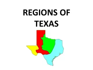
SECTION 1:A Regional Crossroads WHY TEXAS IS A CROSSROADS OF NATURAL REGIONS • Four of the natural regions extend into Texas – more than any other state
SECTION 1:A Regional Crossroads FOUR NATURAL REGIONS OF TEXAS • GULF COASTAL PLAIN • CENTRAL PLAINS • GREAT PLAINS • INTERMOUNTAIN BASINS AND PLATEAUS
SECTION 2: The Gulf Coastal Plain OBJECTIVES • Compare and contrast the features of the subregions of the Gulf Coast Plain. • Explain how Texans in the Gulf Coastal Plain have adapted to and used their environment.
SECTION 2: The Gulf Coastal Plain COMPARE AND CONTRAST THE SUBREGIONS OF THE GULF COAST PLAIN • Piney Woods – pine forest, farming, timber • Gulf Coast Plain – prairie, bayous, farming, ranching, fishing, ports, oil, petrochemicals • South Texas Plains – warm dry climate, year-round farming, ranches • Post Oak Belt – sandy soils, prairies, farming, energy resources • Blackland Prairie – rich soil, large population, manufacturing
SECTION 2: The Gulf Coastal Plain THE GULF COAST PLAINS ADAPTS TO ENVIRONMENT • Houston – petrochemicals, shipping, manufacturing • Dallas – banking, manufacturing, corporate headquarters • San Antonio – tourism, military, retail • Laredo – trade, farming
SECTION 3: The Central Plains OBJECTIVES • Identify the different physical and human characteristics of the subregions of the Central Plains. • Explain how the physical features of the Central Plains affect industry in the region.
SECTION 3: The Central Plains PHYSICAL AND HUMAN CHARACTERISTICS OF CENTRAL PLAINS SUBREGIONS • GRAND PRAIRIE – flat and rolling hills, grasslands; suited for livestock • CROSS TIMBERS – sandy soil; good for farming a variety of crops • ROLLING PLAINS – grasslands; hilly terrain; steep valley; rivers; suited for cattle and ranches
SECTION 3: The Central Plains PHYSICAL FEATURES OF THE CENTRAL PLAINS AFFECT INDUSTRY • Rich soils support farm industries • Natural resources have spurred other industries
SECTION 4: The Great Plains OBJECTIVES • Describe the physical features of the Great Plains. • Identify how Texans have adapted to the environment of the Great Plains.
SECTION 4: The Great Plains PHYSICAL FEATURES OF THE GREAT PLAINS • High and flat • Caprock prairie with elevation rising to the east • Escarpments along the eastern and western edges • Red River forms Palo Duro Canyon Caprock – hard bed of rock below the soil of the High Plains Escarpment – cliffs
SECTION 4: The Great Plains TEXANS HAVE ADAPTED TO THE ENVIRONMENT OF THE GREAT PLAINS • Used grasslands for farming • Pumped water for irrigating crops • Drilled for oil and gas • Built cities
SECTION 5: The Intermountain Basins and Plateaus OBJECTIVES • Identify the physical characteristics of the Intermountain Basins and Plateaus. • Explain how the geography of the region affects human activities there.
SECTION 5: The Intermountain Basins and Plateaus PHYSICAL CHARACTERISTICS OF THE INTERMOUNTAIN BASINS AND PLATEAUS • Dry desert climate • Rocky soil • Mountains, Canyons, Basins • Plateaus • Limited Plant Life
SECTION 5: The Intermountain Basins and Plateaus HUMAN ACTIVITY IS AFFECTED BY GEOGRAPHY • Landscape has made tourism a large part of the economy • Business proper for offering services to tourists