Download
1 / 17
180 likes | 320 Vues
The EQUAL project, led by RIVM and funded by ESA, aims to validate Envisat's ozone and temperature profiles over a long-term period. By utilizing data from GOMOS, MIPAS, and SCIAMACHY, the project monitors data quality and assesses instrument health. Key tasks include processing lidar measurements, comparing satellite data with reference lidar profiles, and reporting on the data quality. This initiative supports the overarching goal of ensuring the accuracy and reliability of satellite measurements crucial for atmospheric monitoring.

E N D
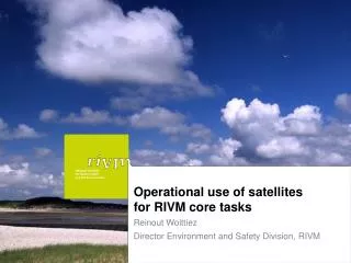
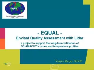
- EQUAL - Envisat Quality Assessment with Lidara project to support the long-term validation of SCIAMACHY’s ozone and temperature profiles Yasjka Meijer, RIVM
Project basics - 1 • ESA-funded project (led by RIVM, D.P.J. Swart) • Long term validation of Envisat products • Ozone profiles, temperature profiles • Gomos, Mipas and Sciamachy • Monitoring the data quality (health of instruments and processing chain) during satellite’s lifetime • Validate new releases of data (processor upgrades) • Reference: lidar data of 11 NDSC stations • Timeframe: 2004 - 2005 (probable extension to 2007)
Lidar data quality O3(r), 12-50 km T(r), 12-75 km From Keckhut et al. [2004, table 3]. Keckhut, P., et al., Review of ozone and temperature lidar validations performed within the framework of the Network for the Detection of Stratospheric Change, J. Environ. Monit., 6, 721–733, 2004.
List of lidar locations GREY = currently unavailable at NILU
Work Package 1 Involves everything needed between lidar data acquisition and submission to the NILU database. Project basics - 2 Work Package 2 Involves analyses and reporting of the quality regarding the ozoneand temperatureprofiles of ENVISAT (i.e., GOMOS, MIPAS, and SCIAMACHY).
Satellite: ESA processing (diverse) (Other sources, scientific) ESA Database NL_SCIA_DC Database @ RIVM of collocated data Groundbased lidars: Individual PI processing NILU Database (contributions either through RIVM or directly) Database @ RIVM of collocated data Data used in project
Lidar Data 2003 817
Lidar Data 2004 592
Analysis • RIVM main focal point (1+ fte), Yasjka Meijer • Dedicated analysis for SCIA, Dorien Lolkema • Some other partners also active in analysis (e.g., dr K.H. Fricke,U. Bonn Lidar at Esrange used for SCIAMACHY validation) • Reporting of analysis results: • through ESA’s Quality Working Groups (QWG) • through SCIAVALIG • ACVE workshops • conferences and symposia • scientific publications
First analysis results 1/2 • Initial focus has been on GOMOS ozone profiles Example of main analysis result Meijer, Y. J., et al. (2004), Pole-to-pole validation of Envisat GOMOS ozone profiles using data from ground-based and balloon sonde measurements, J. Geophys. Res., 109, doi:10.1029/2004JD004834.
V5.4b V6.0a Aer1ol First analysis results 2/2 • Fast standard analysis, performed within 1 day! April 2004: significant contribution for decision on processor setting
For more information, please contact yasjka.meijer@rivm.nl or daan.swart@rivm.nl, and see next presentation by Dorien Lolkema
Work Package 1 Involves everything needed between lidar data acquisition and submission to the NILU database. In particular: Performance check of lidar measurements Processing to temperature and/or ozone profiles Checking of data quality Data formatting to NILU database HDF Uploading to NILU database Monthly reports on data statistics per contributing institute. Project basics - 1/3
Work Package 2 Involves tasks to analyse and report on the quality of the temperature and ozone profiles of ENVISAT (i.e., GOMOS, MIPAS, and SCIAMACHY). In particular: Request and download ENVISAT data. Understanding and reading of ENVISAT data. Derive lists of collocated measurements between ENVISAT and lidar observations. Perform comparison studies between ENVISAT and lidar profiles of ozone and temperature. ------> continued ------> Project basics - 2/3
Continuation of Work Package 2 Perform analysis studies to estimate absolute and random differences between ESA delivered products and the lidar measurements. Identify possible error dependencies on independent variables (e.g., altitude, latitude, illumination conditions, etc.). Generate contributions to the ACVE meetings. Generate 2 web articles for ESA web site. Generate validation reports. Generate annual report. Generate final report. Organize Project Workshops to inform the contributing NDSC partner institutes of the analysis results. Project basics - 3/3